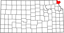
Doniphan County, Kansas
| Doniphan County, Kansas | |
|---|---|
| County | |
 | |
 Location in the U.S. state of Kansas | |
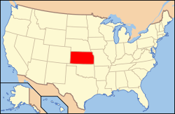 Kansas's location in the U.S. | |
| Founded | August 25, 1855 |
| Named for | Alexander William Doniphan |
| Seat | Troy |
| Largest city | Wathena |
| Area | |
| • Total | 398 sq mi (1,031 km2) |
| • Land | 393 sq mi (1,018 km2) |
| • Water | 4.9 sq mi (13 km2), 1.2% |
| Population | |
| • (2010) | 7,945 |
| • Density | 20/sq mi (8/km²) |
| Congressional district | 2nd |
| Time zone | Central: UTC-6/-5 |
| Website |
DpCountyKS |
Coordinates: 39°48′N 95°07′W / 39.800°N 95.117°W
Doniphan County (county code DP) is a county located in the U.S. state of Kansas. As of the 2010 census, the county population was 7,945.[1] Its county seat is Troy,[2] and its most populous city is Wathena.
History
Early history
For many millennia, the Great Plains of North America was inhabited by nomadic Native Americans. From the 16th century to 18th century, the Kingdom of France claimed ownership of large parts of North America. In 1762, after the French and Indian War, France secretly ceded New France to Spain, per the Treaty of Fontainebleau.
19th century
In 1802, Spain returned most of the land to France, but keeping title to about 7,500 square miles. In 1803, most of the land for modern day Kansas was acquired by the United States from France as part of the 828,000 square mile Louisiana Purchase for 2.83 cents per acre.
In 1854, the Kansas Territory was organized, then in 1861 Kansas became the 34th U.S. state. Doniphan County was established on August 25, 1855, then organized on September 18, 1855. It is named for the U.S. cavalry commander Colonel Alexander W. Doniphan[3] (1808–1887) of Liberty, Missouri, who played an important part in the Mexican-American War. He was a zealous partisan in the failed effort made to extend slavery into Kansas.
Geography
Doniphan County is located in the northeastern corner of the state—it is bordered by Nebraska to the north and Missouri to the east. According to the U.S. Census Bureau, the county has a total area of 398 square miles (1,030 km2), of which 393 square miles (1,020 km2) is land and 4.9 square miles (13 km2) (1.2%) is water.[4] It is the third-smallest county in Kansas by land area and second-smallest by total area.
Geographic features
The Missouri River defines the border in the north and east. Eight barge lines travel the river, and a Port Authority is located across the river in Saint Joseph, Missouri. The river provides much of the water for the eastern part of the county. Interior cities, such as Troy and Highland, receive their water from underground wells. The Wolf River flows through western portions of the county and north into the Missouri River.
Major highways
The only major highway serving the county is U.S. Highway 36, an east/west route traveling through St. Joseph. Troy, Elwood, and Wathena lie along this route. Kansas state highways K-7, K-20, K-120, K-136, K-137, and K-238 serve other areas of the county. K-7 has been designated a scenic byway. (See the map below.)
Adjacent counties
- Holt County, Missouri (north)
- Andrew County, Missouri (northeast)
- Buchanan County, Missouri (southeast)
- Atchison County (southwest)
- Brown County (west)
- Richardson County, Nebraska (northwest)
Demographics
| Historical population | |||
|---|---|---|---|
| Census | Pop. | %± | |
| 1860 | 8,083 | — | |
| 1870 | 13,969 | 72.8% | |
| 1880 | 14,257 | 2.1% | |
| 1890 | 13,535 | −5.1% | |
| 1900 | 15,079 | 11.4% | |
| 1910 | 14,422 | −4.4% | |
| 1920 | 13,438 | −6.8% | |
| 1930 | 14,063 | 4.7% | |
| 1940 | 12,936 | −8.0% | |
| 1950 | 10,499 | −18.8% | |
| 1960 | 9,574 | −8.8% | |
| 1970 | 9,107 | −4.9% | |
| 1980 | 9,268 | 1.8% | |
| 1990 | 8,134 | −12.2% | |
| 2000 | 8,249 | 1.4% | |
| 2010 | 7,945 | −3.7% | |
| Est. 2015 | 7,797 | [5] | −1.9% |
| U.S. Decennial Census[6] 1790-1960[7] 1900-1990[8] 1990-2000[9] 2010-2013[1] | |||

Doniphan County is included in the St. Joseph, MO-KS Metropolitan Statistical Area, which is also included in the Kansas City-Overland Park-Kansas City, MO-KS Combined Statistical Area.
As of the U.S. Census in 2000,[10] there were 8,249 people, 3,173 households, and 2,183 families residing in the county. The population density was 21 people per square mile (8/km²). There were 3,489 housing units at an average density of 9 per square mile (3/km²). The racial makeup of the county was 94.85% White, 2.00% Black or African American, 1.21% Native American, 0.25% Asian, 0.40% from other races, and 1.29% from two or more races. Hispanic or Latino of any race were 1.16% of the population.
There were 3,173 households out of which 32.60% had children under the age of 18 living with them, 56.40% were married couples living together, 8.70% had a female householder with no husband present, and 31.20% were non-families. 27.60% of all households were made up of individuals and 14.20% had someone living alone who was 65 years of age or older. The average household size was 2.48 and the average family size was 3.03.
In the county the population was spread out with 25.30% under the age of 18, 11.80% from 18 to 24, 24.70% from 25 to 44, 22.00% from 45 to 64, and 16.20% who were 65 years of age or older. The median age was 37 years. For every 100 females there were 98.60 males. For every 100 females age 18 and over, there were 96.20 males.
The median income for a household in the county was $32,537, and the median income for a family was $39,357. Males had a median income of $28,096 versus $19,721 for females. The per capita income for the county was $14,849. About 9.00% of families and 11.90% of the population were below the poverty line, including 13.30% of those under age 18 and 12.50% of those age 65 or over.
Law and government
Doniphan County is served by a Board of County Commissioners composed of one elected official from each of three districts. The commissioners serve four-year terms with the 2nd and 3rd district elections following two years after the 1st district election. The board is responsible for setting the county's policies, procedures, and budgets as well as overseeing functions of their respective road and bridge shops. In addition, the board acts as the Board of County Canvassers and canvasses votes cast at each election. The county has adopted comprehensive county planning and zoning codes. The cities are governed by mayors and city councils. Government services are paid for through a sales tax, property tax, and an ad valorem tax mill levy.
Although the Kansas Constitution was amended in 1986 to allow the sale of alcoholic liquor by the individual drink with the approval of voters, Doniphan County remained a prohibition, or "dry", county until 2012.[11]
Doniphan County has voted for the Republican nominee in every presidential election since Kansas became a state, beginning in 1864. In the last four presidential elections, the Republican candidate has received over 60% of the vote.[12]
Education
Unified school districts
Colleges and universities
Highland Community College was the first college established in the state when the Highland University charter was granted by the Territorial Legislature in 1858. Over time the college lost its affiliation with the Presbyterian Church and changed its name several times before becoming a regional rural community college. (Web site)
Communities

Cities
Unincorporated communities
Townships
Doniphan County is divided into nine mostly rural townships. The three townships with the greatest population lie along U.S. Highway 36. None of the cities within the county are considered governmentally independent, and all figures for the township include those of the cities. In the following table, the population center is the largest city (or cities) included in that township's population total, if it is of a significant size.
| Township | FIPS | Population center |
Population | Population density /km² (/sq mi) |
Land area km² (sq mi) | Water area km² (sq mi) | Water % | Geographic coordinates |
|---|---|---|---|---|---|---|---|---|
| Burr Oak | 09500 | 153 | 2 (5) | 81 (31) | 2 (1) | 2.73% | 39°51′17″N 94°58′19″W / 39.85472°N 94.97194°W | |
| Center | 11700 | Troy | 1,743 | 11 (28) | 162 (63) | 2 (1) | 1.31% | 39°47′35″N 95°5′30″W / 39.79306°N 95.09167°W |
| Independence | 33850 | 342 | 4 (9) | 96 (37) | 0 (0) | 0.01% | 39°42′13″N 95°11′8″W / 39.70361°N 95.18556°W | |
| Iowa | 34400 | Highland | 1,694 | 8 (20) | 216 (83) | 2 (1) | 1.05% | 39°53′12″N 95°15′3″W / 39.88667°N 95.25083°W |
| Marion | 44675 | 226 | 5 (13) | 45 (17) | 1 (1) | 2.84% | 39°43′29″N 94°59′43″W / 39.72472°N 94.99528°W | |
| Union | 72125 | 360 | 4 (10) | 94 (36) | 0 (0) | 0.09% | 39°42′14″N 95°16′27″W / 39.70389°N 95.27417°W | |
| Washington | 75600 | Wathena, Elwood | 3,066 | 36 (94) | 85 (33) | 4 (1) | 4.30% | 39°45′39″N 94°55′38″W / 39.76083°N 94.92722°W |
| Wayne | 76100 | 226 | 2 (6) | 92 (36) | 1 (0) | 0.73% | 39°40′56″N 95°4′57″W / 39.68222°N 95.08250°W | |
| Wolf River | 80275 | 439 | 3 (8) | 145 (56) | 0 (0) | 0.02% | 39°46′54″N 95°14′26″W / 39.78167°N 95.24056°W | |
| Sources: "Census 2000 U.S. Gazetteer Files". U.S. Census Bureau, Geography Division. | ||||||||
Points of interest
- Native American Heritage Museum, 2 miles east of Highland : Originally a Presbyterian Mission built in 1845 to educate Iowa and Missouri Sac and Fox children, the museum was rehabilitated to showcase the arts and history of the emigrant tribes in northeastern Kansas. (Web site)
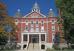
- Nelson Rodgers House, in Troy : Built in 1856, this 1 1⁄2-story center-gable house constructed of hand-hewn timbers is the first and oldest remaining house in Troy.
- Four-state Lookout, in White Cloud : This viewing platform provides a panoramic view of the Missouri River valley, including Kansas, Missouri, Nebraska, and (possibly) Iowa.
- Townsite of Old Doniphan : On July 4, 1804 the Lewis and Clark Expedition camped near an uninhabited Kanza Indian village on Independence Creek. The former town of Doniphan was established in the vicinity of the campsite.
See also
|
|
References
- 1 2 "State & County QuickFacts". United States Census Bureau. Retrieved July 24, 2014.
- ↑ "Find a County". National Association of Counties. Retrieved 2011-06-07.
- ↑ Gannett, Henry (1905). The Origin of Certain Place Names in the United States. Govt. Print. Off. p. 107.
- ↑ "US Gazetteer files: 2010, 2000, and 1990". United States Census Bureau. 2011-02-12. Retrieved 2011-04-23.
- ↑ "County Totals Dataset: Population, Population Change and Estimated Components of Population Change: April 1, 2010 to July 1, 2015". Retrieved July 2, 2016.
- ↑ "U.S. Decennial Census". United States Census Bureau. Retrieved July 24, 2014.
- ↑ "Historical Census Browser". University of Virginia Library. Retrieved July 24, 2014.
- ↑ "Population of Counties by Decennial Census: 1900 to 1990". United States Census Bureau. Retrieved July 24, 2014.
- ↑ "Census 2000 PHC-T-4. Ranking Tables for Counties: 1990 and 2000" (PDF). United States Census Bureau. Retrieved July 24, 2014.
- ↑ "American FactFinder". United States Census Bureau. Retrieved 2008-01-31.
- ↑ "2012 Kansas Liquor by the Drink Map (Wet and Dry Counties)" (PDF). Property Valuation Division, GIS Section, Kansas Department of Revenue. December 2012. Retrieved 2013-04-01.
- ↑ The New York Times electoral map (Zoom in on Kansas)
Further reading
- History of the State of Kansas; William G. Cutler; A.T. Andreas Publisher; 1883. (Online HTML eBook)
- Kansas : A Cyclopedia of State History, Embracing Events, Institutions, Industries, Counties, Cities, Towns, Prominent Persons, Etc; 3 Volumes; Frank W. Blackmar; Standard Publishing Co; 944 / 955 / 824 pages; 1912. (Volume1 - Download 54MB PDF eBook),(Volume2 - Download 53MB PDF eBook), (Volume3 - Download 33MB PDF eBook)
External links
| Wikimedia Commons has media related to Doniphan County, Kansas. |
- County
- Additional information
- Lewis & Clark in Kansas: Doniphan County Attractions
- Doniphan County 1882 Historical Plat Book
- County Level Data from Kansas Statistical Abstract
- Kansas State Historical Society
- General county information
- Maps
- Doniphan County Maps: Current, Historic, KDOT
- Kansas Highway Maps: Current, Historic, KDOT
- Kansas Railroad Maps: Current, 1996, 1915, KDOT and Kansas Historical Society
 |
Richardson County, Nebraska | Holt County, Missouri | Andrew County, Missouri | |
| Brown County | |
|||
| ||||
| | ||||
| Atchison County | Buchanan County, Missouri |
Municipalities and communities of Doniphan County, Kansas, United States | ||
|---|---|---|
| Cities | | |
| CDP | ||
| Unincorporated communities | ||
| Ghost town | ||
| Indian reservation | ||
| Townships | ||
| Footnotes | ‡This populated place also has portions in an adjacent county or counties | |