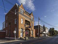
Union Bridge Historic District
|
Union Bridge Historic District | |
 | |
  | |
| Location | Roughly bounded by Bellevue, E. Locust, Buttersburg Alley, Church, Whyte, W. Locust and the Western Maryland RR tracks, Union Bridge, Maryland |
|---|---|
| Coordinates | 39°34′3″N 77°10′40″W / 39.56750°N 77.17778°WCoordinates: 39°34′3″N 77°10′40″W / 39.56750°N 77.17778°W |
| Area | 100 acres (40 ha) |
| Built | 1861 |
| Architect | Wolfe, Joseph; Gott, Jackson, et al. |
| Architectural style | Late Victorian, Late 19th And 20th Century Revivals, Late 19th And Early 20th Century American Movements |
| NRHP Reference # | 94000820[1] |
| Added to NRHP | August 17, 1994 |
Union Bridge Historic District is a national historic district at Union Bridge, Carroll County, Maryland, United States. The district consists of this small piedmont village, which serves the area as a market center for the surrounding agricultural area. The greatest growth occurred in the 1880s after the Western Maryland Railway built its shops here.[2]
It was added to the National Register of Historic Places in 1994.[1]
See also
- Union Bridge Station - Historic railway station
References
- 1 2 National Park Service (2010-07-09). "National Register Information System". National Register of Historic Places. National Park Service.
- ↑ Kenneth M. Short (December 1992). "National Register of Historic Places Registration: Union Bridge Historic District" (PDF). Maryland Historical Trust. Retrieved 2016-01-01.
External links
- Union Bridge Historic District, Carroll County, including photo from 2006, at Maryland Historical Trust
- Boundary Map of the Union Bridge Historic District, Carroll County, at Maryland Historical Trust
| Topics |  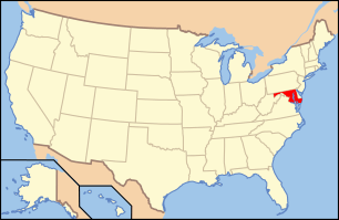 | |
|---|---|---|
| Lists by county | ||
| Lists by city | ||
| Other lists | ||
| ||
This article is issued from Wikipedia - version of the 11/29/2016. The text is available under the Creative Commons Attribution/Share Alike but additional terms may apply for the media files.