Underwood, Washington
| Underwood, Washington | |
|---|---|
| Unincorporated community | |
|
Post Office | |
 Underwood, Washington | |
| Coordinates: 45°43′46″N 121°31′34″W / 45.72944°N 121.52611°WCoordinates: 45°43′46″N 121°31′34″W / 45.72944°N 121.52611°W | |
| Country | United States |
| State | Washington |
| County | Skamania |
| Elevation | 118 ft (36 m) |
| Time zone | Pacific (PST) (UTC-8) |
| • Summer (DST) | PDT (UTC-7) |
| ZIP code | 98651 |
| Area code(s) | 509 |
| GNIS feature ID | 1512748[1] |
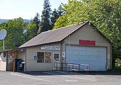
Underwood is an unincorporated community in Skamania County, Washington, United States. Underwood is located along Washington State Route 14 at the confluence of the White Salmon and Columbia Rivers. It is across the Columbia River from Hood River, Oregon, and 2 miles (3.2 km) west of White Salmon, Washington. Underwood has a post office with ZIP code 98651.[2]
A post office called Underwood has been in operation since 1900.[3] The community has the name of Amos Underwood, a pioneer settler.[4]
References
- ↑ U.S. Geological Survey Geographic Names Information System: Underwood, Washington
- ↑ ZIP Code Lookup
- ↑ "Post Offices". Jim Forte Postal History. Retrieved 25 August 2016.
- ↑ Meany, Edmond S. (1923). Origin of Washington geographic names. Seattle: University of Washington Press. p. 321.
Municipalities and communities of Skamania County, Washington, United States | ||
|---|---|---|
| Cities |  | |
| CDP | ||
| Unincorporated communities | ||
This article is issued from Wikipedia - version of the 8/27/2016. The text is available under the Creative Commons Attribution/Share Alike but additional terms may apply for the media files.