U.S. Route 33 in Michigan
| ||||
|---|---|---|---|---|
|
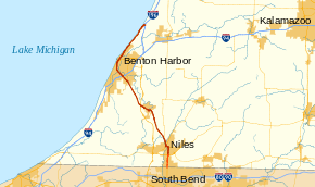
US 33 highlighted in red | ||||
| Route information | ||||
| Maintained by MDOT | ||||
| Length: | 2.835 mi[1] (4.562 km) | |||
| Existed: | 1937[2][3] – April 25, 1997[4] | |||
| History: | Last signage removed in April 1998[5] | |||
| Major junctions | ||||
| South end: |
| |||
| North end: |
| |||
| Location | ||||
| Counties: | Berrien | |||
| Highway system | ||||
| ||||

US Highway 33 (US 33) is a part of the United States Numbered Highway System that was once located in Berrien County, Michigan. At the time it was removed from the state, it was only about 2.8 miles (4.5 km) long running north from the Indiana state line to an intersection with US 12 south of Niles. The highway was not originally part of the US Highway System in the state; it was added in 1937 as a second designation for part of US 31 between the state line and St. Joseph. It was later extended further north to the community of Lake Michigan Beach. This extension became the only section of US 33 that was routed independent of another highway until it was truncated to Niles. In 1997, US 33 was officially removed from the state.
Route description
At the time it last existed in Michigan, US 33 started at the Indiana state line at an intersection with State Line Road. From there it ran due north along 11th Street through a residential neighborhood parallel to the St. Joseph River. Just past an intersection with Fulkerson Road, the highway curved briefly to the northeast as it approached Bell Road. US 33 terminated at a five-ramp partial cloverleaf interchange with US 12 (Pulaski Highway) south of the city of Niles in Bertrand Township.[6][7] According to the Michigan Department of Transportation (MDOT), the agency that maintained the roadway, in 1998, the last year it was US 33, the highway carried between 17,192 and 24,669 vehicles on average, daily.[8] Additionally, the roadway that carried the highway designation is listed on the National Highway System,[9] a network of roads important to the country's economy, defense, and mobility.[10]
History
The State Trunkline Highway System was created on May 13, 1913, by an act of the Michigan Legislature; at the time, one of the system's divisions corresponded to US 33. Division 5 followed a course from Niles northward to Mackinaw City.[11] In 1919, the Michigan State Highway Department (MSHD)[lower-alpha 1] signposted the highway system for the first time,[13] and the future US 33 corridor was assigned the original M-58 designation from the state line northward through Niles to St. Joseph.[14] When the United States Numbered Highway System was created on November 11, 1926,[15] the corridor received the US 31 designation.[16] The US 33 designation was later added to US 31 from the state line northward to St. Joseph in 1937.[2][3]
In November 1960, the US 33 designation was extended northward along US 31 from St. Joseph through Benton Harbor to Lake Michigan Beach[17] Two years later, a segment of freeway opened east of Benton Harbor, and US 31 was rerouted to follow it, leaving US 33 to its own alignment between Scottdale and Lake Michigan Beach. This was the first time that US 33 had a section of its routing in Michigan that was not concurrent with another highway. Also, the northernmost 1⁄2 mile (0.80 km) of US 33 overlapped part of US 31 between the freeway and its old routing, resulting in a wrong-way concurrency.[18][19][lower-alpha 2] This concurrency was removed the next year when another freeway section for I-196/US 31 opened north of the previous endpoint, removing US 31 from Hagar Shores Road.[20] Additional freeway for US 31 was built in the late 1970s into the 1980s. Called the St. Joseph Valley Parkway, the first section of this freeway through Berrien County was completed in 1979 and ran from the Indiana state line north to US 12; after its completion, US 33 had a second independent routing from the state line north to US 12 where US 31 merged back in from its new freeway routing.[21][22]
US 33 was all but eliminated in Michigan on June 9, 1986, when the American Association of State Highway and Transportation Officials (AASHTO) approved a request by MDOT to truncate the designation to the intersection with US 12 south of Niles.[23] A year later, construction of the Niles Bypass was finished, bringing the parkway north to Walton Road northwest of Niles. Signage was updated for US 33 at the same time, and the M-63 designation was assigned to US 33 from Scottdale to Lake Michigan Beach, while the US 31 designation ran solo on the highway between Scottdale and the Niles Bypass. Business US 31 (Bus. US 31) was created along the former routing of US 31/US 33 between the bypass and Niles while the remainder of US 33 through downtown became part of Bus. US 12 or M-51.[24][25] The last segment of US 33 between US 12 and the state line was removed on April 25, 1997, when AASHTO approved a joint request by MDOT and its counterpart in Indiana to truncate the highway designate to an intersection with US 20 in Elkhart, Indiana.[4] This remaining segment in Michigan became part of an extended M-51 when the signage was changed a year later.[5]
On March 5, 2010, a segment of Bus. US 12 previously used by US 33 in downtown Niles was transferred back to city control.[26] Otherwise, all of US 33 at its greatest extent from 1961[18][27] through 1987[24][25] remains part of a state highway in Michigan. From the state line into Niles, it is M-51. From the west side of downtown Niles, it is M-139 to Scottdale, and from there north, it is M-63 [28]
Major intersections
The entire highway was in Bertrand Township, Berrien County.
| mi[1] | km | Destinations | Notes | ||
|---|---|---|---|---|---|
| 0.000 | 0.000 | Continuation into Indiana; now State Road 933 | |||
| 2.835 | 4.562 | Roadway continues north as M-51 | |||
| 1.000 mi = 1.609 km; 1.000 km = 0.621 mi | |||||
See also
 Michigan Highways portal
Notes
- ↑ The Michigan State Highway Department was reorganized into the Michigan Department of State Highways and Transportation on August 23, 1973. The name was shortened to its current form in 1978.[12]
- ↑ Westbound Hagar Shores Road was designated US 31 northbound and US 33 southbound while eastbound along the road was signed for US 31 southbound and US 33 northbound.
References
- 1 2 Michigan Department of Transportation & Michigan Center for Shared Solutions and Technology Partnerships (2009). MDOT Physical Reference Finder Application (Map). Michigan Department of Transportation. Retrieved April 9, 2015.
- 1 2 Michigan State Highway Department & Rand McNally (May 15, 1937). Official Michigan Highway Map (Map) (Summer ed.). [c. 1:850,000]. Lansing: Michigan State Highway Department. §§ N7–N8. OCLC 12701143. Retrieved December 18, 2016 – via Archives of Michigan.
- 1 2 Michigan State Highway Department & Rand McNally (December 1, 1937). Official Michigan Highway Map (Map) (Winter ed.). [c. 1:850,000]. Lansing: Michigan State Highway Department. § N7–N8. OCLC 12701143. Retrieved December 18, 2016 – via Archives of Michigan.
- 1 2 Zink, Ray (April 27, 1997). "Report of the Special Committee on U.S. Route Numbering to the Standing Committee on Highways" (PDF) (Report). Des Moines, IA: American Association of State Highway and Transportation Officials. Retrieved April 9, 2015.
- 1 2 "Portion of US 33 Is Now Indiana 933: Name Changes Along Lincoln Way, North to State Line". South Bend Tribune. April 18, 1998. p. A6. OCLC 8793233. Retrieved December 29, 2008 – via ProQuest Archive. (subscription required (help)).
- ↑ Michigan Department of Transportation (1998). Michigan Department of Transportation Map (Map). c. 1:918,720. Lansing: Michigan Department of Transportation. § N7. OCLC 42778335.
- ↑ Google (April 9, 2015). "Overview Map of Former US 33 in Michigan" (Map). Google Maps. Google. Retrieved April 9, 2015.
- ↑ Bureau of Transportation Planning (2008). "Traffic Monitoring Information System". Michigan Department of Transportation. Retrieved April 4, 2015.
- ↑ Michigan Department of Transportation (April 23, 2006). National Highway System, Michigan (PDF) (Map). Scale not given. Lansing: Michigan Department of Transportation. Retrieved October 7, 2008.
- ↑ Natzke, Stefan; Neathery, Mike & Adderly, Kevin (June 20, 2012). "What is the National Highway System?". National Highway System. Federal Highway Administration. Retrieved July 1, 2012.
- ↑ Michigan Legislature (1915) [enacted May 13, 1913]. "Chapter 91: State Reward Trunk Line Highways". In Shields, Edmund C.; Black, Cyrenius P. & Broomfield, Archibald. The Compiled Laws of the State of Michigan, Volume I. Lansing, MI: Wynkoop, Hallenbeck, Crawford. pp. 1868–72. OCLC 44724558 – via Google Books.
- ↑ Kulsea, Bill & Shawver, Tom (1980). Making Michigan Move: A History of Michigan Highways and the Michigan Department of Transportation. Lansing: Michigan Department of Transportation. pp. 27, 30–31. OCLC 8169232.
- ↑ "Michigan May Do Well Following Wisconsin's Road Marking System". The Grand Rapids Press. September 20, 1919. p. 10. OCLC 9975013.
- ↑ Michigan State Highway Department (July 1, 1919). State of Michigan (Map). Scale not given. Lansing: Michigan State Highway Department. Lower Peninsula sheet. OCLC 15607244. Retrieved December 18, 2016 – via Archives of Michigan.
- ↑ McNichol, Dan (2006). The Roads that Built America. New York: Sterling. p. 74. ISBN 1-4027-3468-9. OCLC 63377558.
- ↑ Bureau of Public Roads & American Association of State Highway Officials (November 11, 1926). United States System of Highways Adopted for Uniform Marking by the American Association of State Highway Officials (Map). 1:7,000,000. Washington, DC: U.S. Geological Survey. OCLC 32889555. Retrieved November 7, 2013 – via University of North Texas Libraries.
- ↑ "Route 31 to Become Route 33". The News-Palladium. Benton Harbor, MI. November 5, 1960. §2, p. 17. OCLC 10117334. Retrieved November 9, 2015 – via Newspapers.com.

- 1 2 Michigan State Highway Department (1962). Official Highway Map (Map). [c. 1:918,720]. Lansing: Michigan State Highway Department. § M7. OCLC 12701120, 173191490.
- ↑ Michigan State Highway Department (1963). Official Highway Map (Map). [c. 1:918,720]. Lansing: Michigan State Highway Department. § M7. OCLC 12701120.
- ↑ Mackie, John C. (December 26, 1963). "John Mackie Lists Many Achievements During 1963". Holland Evening Sentinel. p. 22. OCLC 13440201.
- ↑ Michigan Department of State Highways and Transportation (1979). Michigan, Great Lake State: Official Transportation Map (Map) (1978–79 ed.). c. 1:918,720. Lansing: Michigan Department of State Highways and Transportation. §§ N7. OCLC 12701177.
- ↑ Michigan Department of Transportation (1980). Michigan, Great Lake State: Official Transportation Map (Map) (1980–81 ed.). c. 1:918,720. Lansing: Michigan Department of Transportation. §§ N7. OCLC 12701177, 606211521.
- ↑ Special Committee on U.S. Route Numbering (June 9, 1986). "Route Numbering Committee Agenda" (PDF) (Report). State College, PA: American Association of State Highway and Transportation Officials. Retrieved April 9, 2015 – via Wikimedia Commons.
- 1 2 Michigan Department of Transportation (1987). Yes Michigan: Official Transportation Map (Map). c. 1:918,720. Lansing: Michigan Department of Transportation. §§ M7–N7. OCLC 12701177.
- 1 2 Michigan Department of Transportation (1988). Yes Michigan: Department of Transportation Map (Map). c. 1:918,720. Lansing: Michigan Department of Transportation. §§ M7–N7. OCLC 42778335.
- ↑ Michigan Department of Transportation (March 5, 2010). "Contract Number 2010-0086". Michigan Department of Transportation.
- ↑ Michigan State Highway Department (1961). Official Highway Map (Map). [c. 1:918,720]. Lansing: Michigan State Highway Department. § M7. OCLC 12701120, 51857665. (Includes all changes through July 1, 1961)
- ↑ Michigan Department of Transportation (2014). Pure Michigan: State Transportation Map (Map). c. 1:975,000. Lansing: Michigan Department of Transportation. §§ M7–N7. OCLC 42778335, 900162490.
External links
- US 33 at Michigan Highways
| Previous state: Indiana |
Michigan | Next state: Terminus |