Typhoon Haima (2016)
| Typhoon (JMA scale) | |
|---|---|
| Category 5 (Saffir–Simpson scale) | |
 Typhoon Haima approaching the Philippines at peak intensity on October 18 | |
| Formed | October 14, 2016 |
| Dissipated | October 26, 2016 |
| (Extratropical after October 22) | |
| Highest winds |
10-minute sustained: 215 km/h (130 mph) 1-minute sustained: 270 km/h (165 mph) |
| Lowest pressure | 900 hPa (mbar); 26.58 inHg |
| Fatalities | 19 confirmed |
| Damage | $1.93 billion (2016 USD) |
| Areas affected | Caroline Islands, Philippines, Taiwan, China (including South, Hong Kong and East), Japan |
| Part of the 2016 Pacific typhoon season | |
Typhoon Haima, known in the Philippines as Super Typhoon Lawin, was the second most intense tropical cyclone of the North Pacific Ocean in 2016. It is the twenty-second named storm and the eleventh typhoon of the annual typhoon season.
Meteorological history
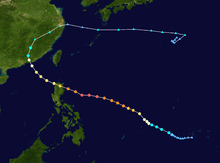
A tropical disturbance began to persist southwest of Chuuk on October 12, and the Joint Typhoon Warning Center (JTWC) issued a Tropical Cyclone Formation Alert to the system one day later, for the rapidly consolidating low-level circulation center (LLCC).[1][2] On October 14, the Japan Meteorological Agency (JMA) reported that the low-pressure area had developed into a tropical depression at 00:00 UTC, about 740 km (460 mi) southeast of Ulithi.[3] When the JTWC also upgraded the system to a tropical depression late on the same day, a point-source anticyclone was providing radial outflow and low vertical wind shear.[4] Early on October 15, for its LLCC being obscured by deepening central convection, the JMA upgraded the system to a tropical storm and named it Haima, and then the JTWC also upgraded it to a tropical storm.[5][6]
Immediately after the JMA indicated that Haima had intensified into a severe tropical storm at 00:00 UTC on October 16, the JTWC upgraded it to a typhoon because of improving banding;[7][8] six hours later, the JMA also upgraded Haima to a typhoon, approximately 140 km (85 mi) northeast of Yap.[9] Tracking west-northwestward along a subtropical ridge to the north, Haima began to form an eye.[10] The typhoon entered the Philippine Area of Responsibility early on October 17 and received the name Lawin from PAGASA, shortly before it deepened further with a sharply-outlined eye.[11][12] Later, an eyewall replacement cycle occurred, as microwave satellite imagery revealed a solid inner ring of deep convection with a secondary outer ring.[13]
Haima completed the eyewall replacement cycle by the morning on October 18. At this time, the JTWC upgraded it to a super typhoon.[14] Several hours later, Haima presented a highly symmetric and tightly-wound spiral structure with a 55 km (35 mi)-wide eye. There was a prominent anticyclone feature to the north blocking the usual poleward outflow channel, but given the impressive appearance, the restriction to flow was apparently having limited impact.[15] Located in an area of warm sea surface temperatures near 30 ºC, Haima reached peak intensity at around 18:00 UTC, with the central pressure at 900 hPa (26.58 inHg) and ten-minute maximum sustained winds at 215 km/h (130 mph).[16] That intensity made Haima the second most intense tropical cyclone of the Northwest Pacific Ocean in 2016, after Typhoon Meranti.[17] Simultaneously, the JTWC estimated one-minute maximum sustained winds at 270 km/h (165 mph), equivalent to Category 5 on the Saffir–Simpson scale.[15] As Haima continued approaching and interacting with Luzon on October 19, the core convection became elongated with another eyewall replacement cycle, leading to a weakening trend and a cloud-filled eye.[18] The JTWC downgraded Haima to a Category 4-equivalent typhoon with 1-minute sustained winds of 220 km/h (140 mph). Subsequently, the system made landfall over Peñablanca, Cagayan of the Philippines at 23:00 PST (15:00 UTC).[19]
When Haima entered the South China Sea shortly before 08:00 PST (00:00 UTC) on October 20, the typhoon had weakened significantly but become larger.[20] Although Haima kept deteriorating gradually over decreasing ocean heat content, the system soon regained a ragged 150 km (90 mi)-wide eye. Environmental conditions at this time included increasing vertical wind shear slightly offset by good dual outflow channels.[21] Turning north-northwestward along the periphery of a subtropical ridge positioned to the north and east, Haima made landfall over Haifeng County, Shanwei in the Guangdong province of China at 12:40 CST (04:40 UTC) on October 21.[22][23] Several hours later, Haima weakened into a severe tropical storm owing to the rugged terrain, and the JTWC issued its final warning on the system.[24][25] The system further weakened into a tropical storm at 12:00 UTC and ultimately a tropical depression in the Jiangxi province at 18:00 UTC.[26][27]
At around 08:00 CST (00:00 UTC) on October 22, Haima became extratropical and accelerated northeastward.[28] Emerging into Hangzhou Bay right before 20:00 CST (12:00 UTC), the low then entered the East China Sea and turned eastward.[29][30] The system developed into a gale-force low near the Tokara Islands early on October 23.[31] Tracking eastward south of Japan, the system weakened into a low below gale-force about 420 km (260 mi) east of Chichijima, at around 09:00 JST (00:00 UTC) on October 25.[32] It then wandered around the area and dissipated early on October 26.[33]
Impact
Philippines

According to the National Disaster Risk Reduction and Management Council (NDRRMC), in the Cordillera Administrative Region, Typhoon Haima (Lawin) killed 14 people, and damages had reached up to ₱3.73 billion (US$76.9 million) as of October 25.[34] Though some recent reports have already counted the death toll up to 18 with agriculture damages up to ₱6.9 billion (US$143.3 million).[35][36]
China
Typhoon Haima caused all schools and many businesses in the cities of Guangzhou, Shenzhen, Dongguan and many others in the south of China to close for the day. Multiple warnings were sent out via different media outlets in order to warn people in advance.
In Guandong, it has been reported that agricultural and economical damages have topped up to ¥3.49 billion (US$517 million).[37] Over in Hainan province though, about 3,400 houses were destroyed with 189,600 hectares of crops destroyed. Losses were amounted to ¥4.18 billion (US$617 million). Moreover, the extratropical remnants of Haima affects East China's Fujian province, with 200 hectares of crop damaged and a possible total loss of ¥37 million (US$5.49 million).[38]
Hong Kong
The approach of Haima prompted the Hong Kong Observatory to issue the No. 8 Gale or Storm Signal; schools and businesses were suspended and roads and pavements empty as Haima passed as close as 110 kilometres east-northeast of the city in the early afternoon of 21 October. “As the western part of Haima’s eye wall is rather close to Hong Kong, gales will affect the territory for some time,” said the observatory, warning the public to steer clear of the waterfront due to rough seas. However, many residents ignored the warning and watched the storm. Haima brought heavy rainfall and gusts of up to 105 kilometres per hour, as waves crashed over and flooded coastal roads and trees were knocked down by winds. Over 700 flights in and out of Hong Kong were cancelled, trading on the city's stock exchange was stopped on 21 October, and ferry services such as Hong Kong’s famous cross-harbour Star Ferry were cancelled. All bus services were halted and underground metro trains were slowed. More than 20 shelters were set up by the government in preparation for the storm.[39] One person was confirmed dead and damages have totalled to HK$5 billion (US$644.5 million).[40]
Macau
The approach of Haima led to the Macau Meteorological and Geophysical Bureau issuing the No. 8 tropical cyclone signal at 08:30 local time for the first time in 2016. However, winds at Macau were much lighter than neighbouring Hong Kong, as the intense rainbands associated with Haima just missed the territory. The No. 3 signal was eventually issued to replace the No. 8 signal at 15:30. The SMG later explained that as Haima took on a more eastward track during the day on 21 October, the intense rainbands and associated gales that were forecast to affect Macau eventually did not impact the territory directly.
Retirement
On October 26, PAGASA has announced that the name Lawin will be removed from their naming lists because it had caused over ₱1 billion in damages.[41]
See also
References
- ↑ "25W.HAIMA Track File". United States Naval Research Laboratory. Retrieved October 19, 2016.
- ↑ "Tropical Cyclone Formation Alert". Joint Typhoon Warning Center. October 13, 2016. Archived from the original on October 19, 2016. Retrieved October 19, 2016.
- ↑ "RSMC Tropical Cyclone Advisory 140000". Japan Meteorological Agency. October 14, 2016. Archived from the original on October 14, 2016. Retrieved October 19, 2016.
- ↑ "Prognostic Reasoning for Tropical Depression 25W (Twentyfive) Warning Nr 01". Joint Typhoon Warning Center. October 14, 2016. Archived from the original on October 14, 2016. Retrieved October 19, 2016.
- ↑ "RSMC Tropical Cyclone Advisory 150000". Japan Meteorological Agency. October 15, 2016. Archived from the original on October 15, 2016. Retrieved October 19, 2016.
- ↑ "Prognostic Reasoning for Tropical Storm 25W (Haima) Warning Nr 02". Joint Typhoon Warning Center. October 15, 2016. Archived from the original on October 15, 2016. Retrieved October 19, 2016.
- ↑ "RSMC Tropical Cyclone Advisory 160000". Japan Meteorological Agency. October 16, 2016. Archived from the original on October 16, 2016. Retrieved October 20, 2016.
- ↑ "Prognostic Reasoning for Typhoon 25W (Haima) Warning Nr 06". Joint Typhoon Warning Center. October 16, 2016. Archived from the original on October 16, 2016. Retrieved October 20, 2016.
- ↑ "RSMC Tropical Cyclone Advisory 160600". Japan Meteorological Agency. October 16, 2016. Archived from the original on October 16, 2016. Retrieved October 20, 2016.
- ↑ "Prognostic Reasoning for Typhoon 25W (Haima) Warning Nr 09". Joint Typhoon Warning Center. October 16, 2016. Archived from the original on October 16, 2016. Retrieved October 20, 2016.
- ↑ "Tropical Cyclone Alert: Typhoon "Lawin" [Haima] Severe Weather Bulletin #1". PAGASA. October 17, 2016. Archived from the original on October 17, 2016. Retrieved October 20, 2016.
- ↑ "Prognostic Reasoning for Typhoon 25W (Haima) Warning Nr 12". Joint Typhoon Warning Center. October 17, 2016. Archived from the original on October 17, 2016. Retrieved October 20, 2016.
- ↑ "Prognostic Reasoning for Typhoon 25W (Haima) Warning Nr 13". Joint Typhoon Warning Center. October 17, 2016. Archived from the original on October 17, 2016. Retrieved October 23, 2016.
- ↑ "Prognostic Reasoning for Super Typhoon 25W (Haima) Warning Nr 15". Joint Typhoon Warning Center. October 18, 2016. Archived from the original on October 18, 2016. Retrieved October 23, 2016.
- 1 2 "Prognostic Reasoning for Super Typhoon 25W (Haima) Warning Nr 17". Joint Typhoon Warning Center. October 18, 2016. Archived from the original on October 18, 2016. Retrieved October 23, 2016.
- ↑ "RSMC Tropical Cyclone Advisory 181800". Japan Meteorological Agency. October 18, 2016. Archived from the original on October 18, 2016. Retrieved October 23, 2016.
- ↑ Kitamoto Asanobu. "Typhoon List (2016)". Digital Typhoon. Retrieved October 23, 2016.
- ↑ "Prognostic Reasoning for Typhoon 25W (Haima) Warning Nr 20". Joint Typhoon Warning Center. October 19, 2016. Archived from the original on October 19, 2016. Retrieved October 24, 2016.
- ↑ "Update: At 11:00 PM today (19 October 2016), STY #LawinPH has made landfall over Baguio Pt., Peñablanca, Cagayan (17.6°N, 122.2°E).". Facebook. PAGASA. Retrieved October 20, 2016.
- ↑ "Prognostic Reasoning for Typhoon 25W (Haima) Warning Nr 22". Joint Typhoon Warning Center. October 20, 2016. Archived from the original on October 20, 2016. Retrieved October 24, 2016.
- ↑ "Prognostic Reasoning for Typhoon 25W (Haima) Warning Nr 24". Joint Typhoon Warning Center. October 20, 2016. Archived from the original on October 20, 2016. Retrieved October 24, 2016.
- ↑ "Prognostic Reasoning for Typhoon 25W (Haima) Warning Nr 26". Joint Typhoon Warning Center. October 21, 2016. Archived from the original on October 21, 2016. Retrieved October 24, 2016.
- ↑ "中央气象台21日12时40分发布台风登陆消息" (in Chinese). National Meteorological Center. October 21, 2016. Archived from the original on October 21, 2016. Retrieved October 21, 2016.
- ↑ "RSMC Tropical Cyclone Advisory 210600". Japan Meteorological Agency. October 21, 2016. Archived from the original on October 21, 2016. Retrieved October 24, 2016.
- ↑ "Typhoon 25W (Haima) Warning Nr 027". Joint Typhoon Warning Center. October 21, 2016. Archived from the original on October 21, 2016. Retrieved October 24, 2016.
- ↑ "RSMC Tropical Cyclone Advisory 211200". Japan Meteorological Agency. October 21, 2016. Archived from the original on October 21, 2016. Retrieved October 24, 2016.
- ↑ "RSMC Tropical Cyclone Advisory 211800". Japan Meteorological Agency. October 21, 2016. Archived from the original on October 21, 2016. Retrieved October 24, 2016.
- ↑ "Marine Weather Warning for GMDSS Metarea XI 2016-10-22T00:00:00Z". WIS Portal – GISC Tokyo. Japan Meteorological Agency. October 22, 2016. Retrieved October 24, 2016.
- ↑ "Marine Weather Warning for GMDSS Metarea XI 2016-10-22T12:00:00Z". WIS Portal – GISC Tokyo. Japan Meteorological Agency. October 22, 2016. Retrieved October 24, 2016.
- ↑ "Marine Weather Warning for GMDSS Metarea XI 2016-10-22T18:00:00Z". WIS Portal – GISC Tokyo. Japan Meteorological Agency. October 22, 2016. Retrieved October 24, 2016.
- ↑ "Marine Weather Warning for GMDSS Metarea XI 2016-10-23T06:00:00Z". WIS Portal – GISC Tokyo. Japan Meteorological Agency. October 23, 2016. Retrieved October 24, 2016.
- ↑ "Marine Weather Warning for GMDSS Metarea XI 2016-10-25T00:00:00Z". WIS Portal – GISC Tokyo. Japan Meteorological Agency. October 26, 2016. Retrieved October 28, 2016.
- ↑ "Marine Weather Warning for GMDSS Metarea XI 2016-10-26T12:00:00Z". WIS Portal – GISC Tokyo. Japan Meteorological Agency. October 26, 2016. Retrieved October 28, 2016.
- ↑ "SitRep No.9 re Preparedness Measures & Effects of Super TY LAWIN (I.N. HAIMA)" (PDF). NDRRMC. Retrieved October 25, 2016.
- ↑ "13 dead, P3b lost in Lawin's wake". The Standard PH. October 21, 2016.
- ↑ "'Lawin': 18 dead, 40 thousand people still in shelters". Inquirer. October 22, 2016.
- ↑ "Typhoon Haima causes heavy damage in China". Indian Express. October 23, 2016.
- ↑ "Typhoons impact industries in southern China". Global Times. October 24, 2016.
- ↑ "Typhoon Haima batters Hong Kong as city locks down". straitstimes.com. The Straits Times. 21 October 2016. Retrieved 23 October 2016.
- ↑ "Typhoon Haima leaves one dead in Hong Kong as city counts the cost". South China Morning Post. October 21, 2016. Retrieved October 22, 2016.
- ↑ "Karen, Lawin removed from list of typhoon names". Philstar. October 26, 2016.
External links
| Wikimedia Commons has media related to Typhoon Haima (2016). |
- JMA General Information of Typhoon Haima (1622) from Digital Typhoon
- JMA Best Track Data of Typhoon Haima (1622) (Japanese)
- 25W.HAIMA from the U.S. Naval Research Laboratory
Tropical cyclones of the 2016 Pacific typhoon season | ||||||||||||||||||||||||||||||||||||||||||||||||||||||||||||||||||||||||||||||||||||||||||||||||||||||||||||||||||||||||||||||||||||||||||||||||||
|---|---|---|---|---|---|---|---|---|---|---|---|---|---|---|---|---|---|---|---|---|---|---|---|---|---|---|---|---|---|---|---|---|---|---|---|---|---|---|---|---|---|---|---|---|---|---|---|---|---|---|---|---|---|---|---|---|---|---|---|---|---|---|---|---|---|---|---|---|---|---|---|---|---|---|---|---|---|---|---|---|---|---|---|---|---|---|---|---|---|---|---|---|---|---|---|---|---|---|---|---|---|---|---|---|---|---|---|---|---|---|---|---|---|---|---|---|---|---|---|---|---|---|---|---|---|---|---|---|---|---|---|---|---|---|---|---|---|---|---|---|---|---|---|---|---|---|
 |
| |||||||||||||||||||||||||||||||||||||||||||||||||||||||||||||||||||||||||||||||||||||||||||||||||||||||||||||||||||||||||||||||||||||||||||||||||
| ||||||||||||||||||||||||||||||||||||||||||||||||||||||||||||||||||||||||||||||||||||||||||||||||||||||||||||||||||||||||||||||||||||||||||||||||||