Tutak, Turkey
| Tutak | |
|---|---|
 Tutak | |
| Coordinates: TR 39°32′32″N 42°46′18″E / 39.54222°N 42.77167°ECoordinates: TR 39°32′32″N 42°46′18″E / 39.54222°N 42.77167°E | |
| Country | Turkey |
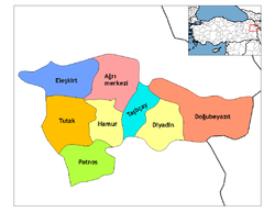
| Province | Ağrı |
| Government | |
| • Mayor | Fırat Öztürk (HDP) |
| • Kaymakam | Gürbüz Saltaş |
| Area[1] | |
| • District | 1,543.98 km2 (596.13 sq mi) |
| Population (2012)[2] | |
| • Urban | 7,184 |
| • District | 34,222 |
| • District density | 22/km2 (57/sq mi) |
| Post code | 04700 |
| Website |
www |
Tutak (Armenian: Դութախ - Duthakh), is a town and a district of Ağrı Province in the Eastern Anatolia region of Turkey. It is located on a small plain surrounded by high mountains and watered by the Murat River, on the road from the city of Ağrı to the district of Patnos. It covers an area of 1,562 km², and the altitude is 1,535 m. Population (2010) is 34,812 of which 7,170 live in the town of Tutak, and the majority in the surrounding countryside. The mayor is Fırat Öztürk (BDP).
Tutak is a small town providing schools, a hospital and other basic amenities to this impoverished rural district. The main source of income in the district is grazing livestock on the mountainside.
Winters are long and hard with a lot of snow, summers are hot and dry.
See also
- 2007 Ağrı earthquake
- Yazidis in Turkey
References
- ↑ "Area of regions (including lakes), km²". Regional Statistics Database. Turkish Statistical Institute. 2002. Retrieved 2013-03-05.
- ↑ "Population of province/district centers and towns/villages by districts - 2012". Address Based Population Registration System (ABPRS) Database. Turkish Statistical Institute. Retrieved 2013-02-27.