Tut, Turkey
| Tut | |
|---|---|
 Tut | |
| Coordinates: TR 37°47′48″N 37°54′54″E / 37.79667°N 37.91500°ECoordinates: TR 37°47′48″N 37°54′54″E / 37.79667°N 37.91500°E | |
| Country | Turkey |
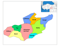
| Province | Adıyaman |
| Government | |
| • Mayor | Cemal Avcı (CHP) |
| • Kaymakam | Mehmet Aksu |
| Area[1] | |
| • District | 486.59 km2 (187.87 sq mi) |
| Elevation | 1,100 m (3,600 ft) |
| Population (2012)[2] | |
| • Urban | 3,760 |
| • District | 10,850 |
| • District density | 22/km2 (58/sq mi) |
| Post code | 02350 |
| Website |
www |
Tut is a green, rural district of Adıyaman Province of Turkey, to the north-west of the city of Adıyaman in the range of the Taurus Mountains called the Haci Muhammed. The mayor is Cemal Avcı (CHP).
This is green, high meadow and the name Tut comes from the Turkish word for mulberry, which grow here in large numbers.
References
- ↑ "Area of regions (including lakes), km²". Regional Statistics Database. Turkish Statistical Institute. 2002. Retrieved 2013-03-05.
- ↑ "Population of province/district centers and towns/villages by districts - 2012". Address Based Population Registration System (ABPRS) Database. Turkish Statistical Institute. Retrieved 2013-02-27.
This article is issued from Wikipedia - version of the 11/11/2016. The text is available under the Creative Commons Attribution/Share Alike but additional terms may apply for the media files.