Tuscola Township, Michigan
| Tuscola Township, Michigan | |
|---|---|
| Township | |
 Tuscola Township, Michigan Location within the state of Michigan | |
| Coordinates: 43°20′53″N 83°38′13″W / 43.34806°N 83.63694°WCoordinates: 43°20′53″N 83°38′13″W / 43.34806°N 83.63694°W | |
| Country | United States |
| State | Michigan |
| County | Tuscola |
| Area | |
| • Total | 33.1 sq mi (85.6 km2) |
| • Land | 33.0 sq mi (85.4 km2) |
| • Water | 0.1 sq mi (0.2 km2) |
| Elevation | 682 ft (208 m) |
| Population (2000) | |
| • Total | 2,152 |
| • Density | 65.3/sq mi (25.2/km2) |
| Time zone | Eastern (EST) (UTC-5) |
| • Summer (DST) | EDT (UTC-4) |
| Area code(s) | 989 |
| FIPS code | 26-80940[1] |
| GNIS feature ID | 1627180[2] |
Tuscola Township is a civil township of Tuscola County in the U.S. state of Michigan. The population was 2,152 at the 2000 census.
The city of Vassar is to the northeast and incorporates some land from the survey township that forms the basis for the present civil township.
History
The township was established in 1840 as a township of Saginaw County and encompassed all of Tuscola County, which had been created by an Act of the Michigan Legislature on April 1, 1840, from land in Sanilac County and attached for administrative purposes to Saginaw County.
Communities
- Tuscola is an unincorporated community in the Township North and South of the Cass River in section 28 at Bray Road 43°19′35″N 83°39′26″W / 43.32639°N 83.65722°W.[3][4] A post off named "Worth" was established on March 6, 1848, with Ebenezer Davis as the first postmaster. The name changed to Tuscola on January 8, 1875. The community was platted in 1850 and the post office operated until January 5, 1962.[5] The plat for the Village of Tuscola south of the River was filed in 1861.[6] The Muro Matheson Addition to the Village plat was filed in May 1868.[7] The city of Vassar post office with ZIP code 48768 provides P.O. Box service.[8]
Geography
According to the United States Census Bureau, the township has a total area of 33.0 square miles (85 km2), of which 33.0 square miles (85 km2) is land and 0.1 square miles (0.26 km2) (0.27%) is water.
 |
Blumfield Township | Denmark Township | Juniata Township | |
| Frankenmuth Township | |
Vassar Vassar Township | ||
| ||||
| | ||||
| Birch Run Township | Arbela Township | Millington Township |
Demographics
As of the census[1] of 2000, there were 2,152 people, 793 households, and 623 families residing in the township. The population density was 65.3 per square mile (25.2/km²). There were 826 housing units at an average density of 25.1 per square mile (9.7/km²). The racial makeup of the township was 98.37% White, 0.42% Native American, 0.33% Asian, 0.65% from other races, and 0.23% from two or more races. Hispanic or Latino of any race were 1.21% of the population.
There were 793 households out of which 34.4% had children under the age of 18 living with them, 69.6% were married couples living together, 6.2% had a female householder with no husband present, and 21.4% were non-families. 18.3% of all households were made up of individuals and 9.5% had someone living alone who was 65 years of age or older. The average household size was 2.71 and the average family size was 3.09.
In the township the population was spread out with 27.3% under the age of 18, 6.7% from 18 to 24, 27.7% from 25 to 44, 25.7% from 45 to 64, and 12.6% who were 65 years of age or older. The median age was 37 years. For every 100 females there were 97.6 males. For every 100 females age 18 and over, there were 95.7 males.
The median income for a household in the township was $49,130, and the median income for a family was $53,750. Males had a median income of $40,568 versus $24,231 for females. The per capita income for the township was $18,986. About 3.3% of families and 4.4% of the population were below the poverty line, including 3.6% of those under age 18 and 5.7% of those age 65 or over.
References
- 1 2 "American FactFinder". United States Census Bureau. Retrieved 2008-01-31.
- ↑ U.S. Geological Survey Geographic Names Information System: Tuscola Township, Michigan
- ↑ U.S. Geological Survey Geographic Names Information System: Tuscola, Michigan
- 1 2 J. Shively (September 2007). "Tuscola County Map" (PDF). County Map Series. State of Michigan Department of Information Technology Technology Michigan Center for Geographic Information. Retrieved 2009-07-07.
- ↑ Romig, Walter (1986) [1973]. Michigan Place Names. Detroit, Michigan: Wayne State University Press. ISBN 0-8143-1838-X.
- ↑ "Tuscola, Village of - South Side of the River". Statewide Results for Subdivision Plats. State of Michigan Bureau of Construction Code. Retrieved 7 July 2009.
- ↑ "Mathennson, Murdo Addition". Statewide Results for Subdivision Plats. State of Michigan Bureau of Construction Code. Retrieved 7 July 2009.
- ↑ ZIP Code Lookup, U.S. Postal Service
Municipalities and communities of Tuscola County, Michigan, United States | ||
|---|---|---|
| Cities | 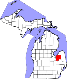 | |
| Villages | ||
| Charter township | ||
| General law townships | ||
| CDP | ||
| Other unincorporated communities | ||
| Footnotes | ‡This populated place also has portions in an adjacent county or counties | |