Trego (CDP), Wisconsin
| Trego, Wisconsin | |
|---|---|
| Census-designated place | |
 Trego, Wisconsin | |
| Coordinates: 45°53′59″N 91°49′16″W / 45.89972°N 91.82111°WCoordinates: 45°53′59″N 91°49′16″W / 45.89972°N 91.82111°W | |
| Country | United States |
| State | Wisconsin |
| County | Washburn |
| Area | |
| • Total | 1.222 sq mi (3.16 km2) |
| • Land | 1.145 sq mi (2.97 km2) |
| • Water | 0.077 sq mi (0.20 km2) |
| Elevation | 1,099 ft (335 m) |
| Population (2010) | |
| • Total | 227 |
| • Density | 190/sq mi (72/km2) |
| Time zone | Central (CST) (UTC-6) |
| • Summer (DST) | CDT (UTC-5) |
| ZIP code | 54888 |
| Area code(s) | 715 and 534 |
| GNIS feature ID | 1575585[1] |
Trego (also Mills, Superior Junction) is an unincorporated census-designated place located in the town of Trego, Washburn County, Wisconsin, United States.
Trego is located at the junction of U.S. Highway 53 and U.S. Highway 63, 6 miles (9.7 km) north–northeast of Spooner.
Trego has a post office with ZIP code 54888.[2] As of the 2010 census, its population is 227.[3]
History
Trego, supposedly meaning "three ways", was so named from its location at a rail junction.[4]
References
- ↑ U.S. Geological Survey Geographic Names Information System: Trego (CDP), Wisconsin
- ↑ ZIP Code Lookup
- ↑ "American FactFinder". U.S. Census Bureau. Retrieved 20 April 2011.
- ↑ Chicago and North Western Railway Company (1908). A History of the Origin of the Place Names Connected with the Chicago & North Western and Chicago, St. Paul, Minneapolis & Omaha Railways. p. 194.
Municipalities and communities of Washburn County, Wisconsin, United States | ||
|---|---|---|
| Cities | 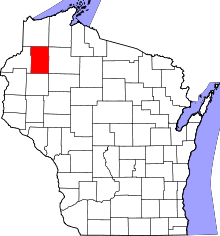 | |
| Villages | ||
| Towns | ||
| CDPs | ||
| Unincorporated communities | ||
| Ghost town | ||
| Indian reservation | ||
| Footnotes | ‡This populated place also has portions in an adjacent county or counties | |
This article is issued from Wikipedia - version of the 10/26/2016. The text is available under the Creative Commons Attribution/Share Alike but additional terms may apply for the media files.