Trawool
| Trawool Victoria | |
|---|---|
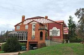 Trawool Hotel and resort, 2009 | |
 Trawool | |
| Coordinates | 37°06′0″S 145°13′0″E / 37.10000°S 145.21667°ECoordinates: 37°06′0″S 145°13′0″E / 37.10000°S 145.21667°E |
| Postcode(s) | 3660 |
| Location | |
| LGA(s) | Shire of Mitchell |
| State electorate(s) | |
| Federal Division(s) | Indi, McEwen |
Trawool is in central Victoria, Australia.[1] The small town lies on the middle reaches of the Goulburn River and on the Goulburn Valley Highway, 115 kilometres (71 mi) north of the state capital, Melbourne.
Originally named Traawool, the indigenous word for ‘wild water’, the district is dominated by agriculture and scenery. First explored by Hume and Hovell in 1824, it was later settled as a large sheep station.
The Trawool Hotel was established at a river crossing site. A punt was used to ferry passengers across the river until a bridge was built. When a railway branch line from Tallarook to Yea was created in 1883 the Trawool railway station was built.
After a period of growth in the 1880s, the settlement went into decline although a granite quarry was established in the area in the early 1890s. Australian and American troops were stationed at Trawool during World War II . Electricity arrived in the district in 1945. However Trawool school closed in 1959, the post office relocated in 1972 and the last train travelled on the local railway line in 1978.
References
- ↑ "Trawool, Victoria". Sydney Morning Herald. 8 February 2004. Retrieved 16 November 2011.
External links
 Media related to Trawool, Victoria at Wikimedia Commons