Shire of Mitchell
| Shire of Mitchell Victoria | |||||||||||||
|---|---|---|---|---|---|---|---|---|---|---|---|---|---|
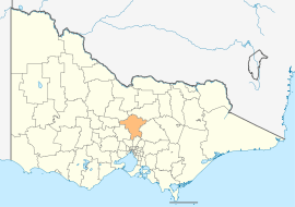 Location in Victoria | |||||||||||||
| Population | 39,143 (2015 est)[1] | ||||||||||||
| • Density | 13.6672/km2 (35.398/sq mi) | ||||||||||||
| Established | 1994 | ||||||||||||
| Gazetted | 18 November 1994[2] | ||||||||||||
| Area | 2,864 km2 (1,105.8 sq mi) | ||||||||||||
| Mayor | Cr Sue Marstaeller | ||||||||||||
| Council seat | Broadford | ||||||||||||
| Region | Hume | ||||||||||||
| State electorate(s) | |||||||||||||
| Federal Division(s) | |||||||||||||
|
| |||||||||||||
| Website | Shire of Mitchell | ||||||||||||
| |||||||||||||
The Shire of Mitchell is a local government area in the Hume region of Victoria, Australia, located North of Melbourne. It covers an area of 2,864 square kilometres (1,106 sq mi) and, at the 2011 Census, had a population of 34,637.[3] It includes the towns of Broadford, Kilmore, Seymour, Tallarook, Pyalong and Wallan. It was formed in 1994 from the amalgamation of the Shire of Pyalong, Shire of Kilmore, most of the Shire of Broadford, and parts of the Shire of McIvor and Rural City of Seymour.[2]
The Shire is governed and administered by the Mitchell Shire Council; its seat of local government and administrative centre is located at the council headquarters in Broadford, it also has service centres located in Kilmore, Seymour and Wallan. The Shire is named after an early British surveyor and explorer, Major Thomas Mitchell, who explored the south-eastern part of Australia, and whose return route for his third expedition passed through the present-day LGA.
It is the second fastest growing regional municipality in Victoria.
Council
Current composition
The council is composed of three wards and nine councillors, with three councillors per ward elected to represent each ward.[4]
| Ward | Councillor | Notes | |
|---|---|---|---|
| Central | Ross Lee | ||
| Rodney Parker | Mayor (2013–14) | ||
| Desmond Callaghan | |||
| North | Bill Chisholm | ||
| Bill Melbourne | |||
| Rhonda Sanderson | |||
| South | Bob Cornish | ||
| Sue Marstaeller | |||
| Kevin Mulroney | |||
Administration and governance
The council meets in the council chambers at the council headquarters in the Broadford Civic Centre, which is also the location of the council's administrative activities. It also provides customer services at both its administrative centre in Broadford, and its service centres in Kilmore, Seymour and Wallan.
See also
References
- ↑ "3218.0 – Regional Population Growth, Australia, 2014–15". Australian Bureau of Statistics. Retrieved 29 September 2016.
- 1 2 Victoria Government Gazette – Online Archive (1837–1997). "S87 of 1994". State Library of Victoria. State Government of Victoria (published 18 November 1994). p. 4. Retrieved 10 January 2014.
|article=ignored (help) - ↑ Census QuickStats (2011). "Mitchell (S) – LGA24850". Australian Bureau of Statistics. Government of Australia. Retrieved 10 January 2014.
- ↑ Local Government in Victoria. "Mitchell Shire Council". Department of Transport, Planning and Local Infrastructure. State Government of Victoria. Retrieved 10 January 2014.
External links
- Mitchell Shire Council official website
- Metlink local public transport map
- Link to Land Victoria interactive maps
Coordinates: 37°06′00″S 145°04′00″E / 37.10000°S 145.06667°E