Mia Mia, Victoria
| Mia Mia Victoria | |
|---|---|
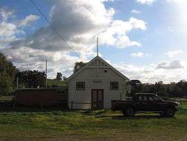 Community Hall | |
 Mia Mia | |
| Coordinates | 37°00′S 144°44′E / 37.000°S 144.733°ECoordinates: 37°00′S 144°44′E / 37.000°S 144.733°E |
| Population | 265 (2011 census)[1] |
| Postcode(s) | 3444 |
| Location | |
| LGA(s) | City of Greater Bendigo |
| State electorate(s) | Euroa |
| Federal Division(s) | Bendigo |
Mia Mia is a picturesque area of Central Victoria, Australia, 119 kilometres (74 mi) north of Melbourne and 56 kilometres (35 mi) south of Bendigo. It is largely an area of broadacre farms raising cattle and sheep. It is a part of the Heathcote wine region Wine District and a number of vineyards have been established in the area, most notably producing Shiraz grapes. Its local government areas are the City of Greater Bendigo and Shire of Mitchell, Mia Mia is part of the Federal Electorates of Bendigo and McEwen and it is in the state electorate of Euroa. In 2011, it had a population of 265.[1]
History
The Post Office opened on 22 November 1861, closing in 1970.[2]
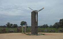
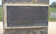
Mia Mia is notable for being the home of John Duigan and brother Reginald Duigan who built and flew the first Australian made aeroplane in 1910 on their property named Spring Plains. A monument to their endeavours was constructed out of local bluestone and unveiled in 1960.
Mia Mia’s western boundary is on the Campaspe River which is crossed by an iron bridge near Redesdale that is unusual in design and is quite memorable for those passing through.
Burke and Wills
The Burke and Wills expedition passed through Mia Mia in 1860 on their journey across Australia from Melbourne to the Gulf of Carpentaria. They arrived on Saturday, 25 August 1860 and made Camp VI, (their sixth camp since leaving Melbourne).[3] Sunday was taken as a rest day when the men caught up on chores and they left on Monday morning. The road from Lancefield to Mia Mia via Ben Loch and the Great Dividing Range is now called 'The Burke and Wills Track'. In 2010 the town erected a small monument to the expedition to mark the sesquicentennary of their visit.
References
- 1 2 Australian Bureau of Statistics (31 October 2012). "Mia Mia". 2011 Census QuickStats. Retrieved 8 January 2014.
- ↑ Premier Postal History, Post Office List, retrieved 2008-04-11
- ↑ Phoenix, Dave (2011). Following Burke and Wills across Victoria : a touring guide. Phoenix. ISBN 978-0-646-56419-7.
External links
| Wikimedia Commons has media related to Mia Mia, Victoria. |
- Burke & Wills Web A comprehensive website containing many of the historical documents relating to the Burke & Wills Expedition.
- The Burke & Wills Historical Society The Burke & Wills Historical Society.