Tower City–Public Square (RTA Rapid Transit station)
| ||||||||||||||||||||
|---|---|---|---|---|---|---|---|---|---|---|---|---|---|---|---|---|---|---|---|---|
| RTA Rapid Transit and light rail station | ||||||||||||||||||||
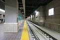
 The westbound Red Line platform | ||||||||||||||||||||
| Location |
230 West Huron Road Cleveland, Ohio 44113 | |||||||||||||||||||
| Coordinates | 41°29′51″N 81°41′38″W / 41.49750°N 81.69389°W | |||||||||||||||||||
| Owned by | Greater Cleveland Regional Transit Authority | |||||||||||||||||||
| Line(s) | ||||||||||||||||||||
| Platforms |
2 low island platforms for light rail 2 high island platforms for rapid transit | |||||||||||||||||||
| Tracks | 2 outer through tracks, 2 inner stub tracks, 1 non-revenue track | |||||||||||||||||||
| Connections |
HealthLine B Line Trolley E Line Trolley Other bus service at Public Square | |||||||||||||||||||
| Construction | ||||||||||||||||||||
| Structure type | Underground | |||||||||||||||||||
| Parking | Paid parking only | |||||||||||||||||||
| Disabled access | Yes | |||||||||||||||||||
| History | ||||||||||||||||||||
| Opened | July 20, 1930 | |||||||||||||||||||
| Rebuilt | December 17, 1990 | |||||||||||||||||||
| Previous names | Public Square | |||||||||||||||||||
| Services | ||||||||||||||||||||
| ||||||||||||||||||||
Tower City–Public Square Station (or simply Tower City Station) is a rapid transit station in Cleveland, Ohio, USA. It is the central station on the RTA Red Line and the major station on the RTA Green and Blue Lines. The station is located directly beneath Prospect Avenue in the middle of the Tower City Center shopping mall. The station is only accessible through the Tower City Center shopping complex, and, for this reason, the public concourse of the shopping mall is open at all times that the RTA Rapid Transit is in operation.
Located in downtown Cleveland, the station is the busiest RTA Rapid Transit station. It is also the only station to serve all of downtown Cleveland, in spite of the fact the Tower City complex is located on the south end of this district near the east shore of the Cuyahoga River; the rest of downtown is serviced by frequent bus service. It offers connections to all RTA buses serving Public Square. The station also includes a "Walkway to Gateway," which is a completely enclosed and air-conditioned skyway from Tower City Center to Quicken Loans Arena and Progressive Field of the Gateway Sports and Entertainment Complex, allowing RTA passengers, as well as those using the Tower City parking facilities, to walk to the arena or ballpark without having to go outside.
Station layout
The station has two fare-collection entrances, one leading to a low platform station for use by the light rail Green and Blue Lines, and one leading to a high platform station for the heavy rail Red Line. Both entrances open from a lobby located on the lowest level of the Tower City shopping mall, and this lobby is accessible by escalators and elevators from the other levels of the mall. Each entrance has multiple fare gates along with two operator booths. The entrance for the Green and Blue Lines collects fares from passengers entering and leaving the station, since westbound passengers pay their fare upon leaving. The Red Line entrance collects fares from passengers entering the station and also requires arriving passengers to swipe their proof of payment card at the gate in order to exit the station.[1] To transfer from the Red Line to the Green or Blue Lines, or vice versa, passengers must exit through the fare gates at one station entrance and enter through the other station entrance. The high and low platform portions of the station can also be reached from each other without going through the lobby by an access passageway located on each side of the lobby along the tracks; however, with the implementation of the proof of payment system on the Red Line, the passageway has been closed.
Platform layout
| Westbound through track | ← Red Line toward Airport (West 25th – Ohio City) ← Blue/Green Lines towards South Harbor (Settlers Landing) | ||||
| Lobby Faregates Exit to Tower City Center |
|||||
| Stub tracks | → Red Line, last stop → ← Red Line toward Airport (West 25th – Ohio City) |
← Blue/Green Lines, last stop → Blue Line toward Warrensville–Van Aken (East 34th – Campus)→ → Green Line toward Green Road (East 34th – Campus) → | |||
| Eastbound through track | Red Line toward Stokes–Windermere (East 34th – Campus) → Blue Line toward Warrensville–Van Aken (East 34th – Campus)→ Green Line toward Green Road (East 34th – Campus) → | ||||
Notable places nearby
- Tower City Center
- Public Square
- Quicken Loans Arena
- Progressive Field
- Downtown Cleveland
- Horseshoe Casino Cleveland
History
When the Cleveland Union Terminal (CUT) was built in 1930 as part of the Terminal Tower complex, the train station allocated the northern set of tracks for interurban or rapid transit service and the southern set of tracks for inter-city rail service. The portion of the station above the interurban tracks was called the Traction Concourse and the portion above the intercity train tracks was called the Steam Concourse. The Van Sweringen brothers who developed Terminal Tower complex and built Cleveland Union Terminal[2] envisioned a network of interurban or rapid transit lines extending from the CUT in all directions. They even acquired right-of-way for some of the lines.
Since the Van Sweringens owned Cleveland Interurban Railroad which served the suburb of Shaker Heights, the interurban portion of the CUT was immediately occupied by the Shaker trains upon completion on July 20, 1930. (Previously, the Shaker trains had used streetcar tracks to reach downtown from East 34th Street, which caused significantly slower service.) The Shaker rapid transit station was located along the northern most tracks of the complex, and it included a small yard for the storage of a few trains and a loop to allow trains to reverse direction. Development of the other interurban services, however, was stalled by the Great Depression, which hit the Van Sweringens particularly hard. By 1944, ownership of the Shaker rapid transit passed to the city of Shaker Heights.
The Shaker rapid transit remained the only service using the interurban portion of the CUT for 25 years. When the Cleveland Transit System built its rapid transit (later designated the Red Line) in 1955 (using much of the right-of-way previously developed by the Van Sweringens), another rapid transit station was built in the former interurban area of the CUT to serve it. Since the CTS Rapid Transit (Red Line) and the Shaker rapid transit (Green and Blue Lines) were owned by different entities at the time, there was no fare transfer between the trains, and the stations were entirely separate. Amtrak left CUT in 1973, using a smaller train station built directly upon the intercity line along the lakefront.
Both lines were merged upon the formation of the Greater Cleveland Regional Transit Authority on September 5, 1975, but the two stations remained separate until December 17, 1990, when a completely new station was built with the development of Tower City Center.[3]
Track Replacement
Beginning July 31, 2016, the RTA began replacing the track bed for track 8, the main westbound track.[4] In order to prevent service disruptions during the track replacement, the RTA temporarily opened its non-revenue track to the public and westbound trains arrived on that track with temporary platforms and station facilities set up. The temporary station was not accessible from the main station entrance and had to be entered from a separate entrance.[5] The new track opened to passengers on November 26, 2016.[6]
Gallery
-

Entrance to the Blue/Green line platforms
-

Eastbound Blue/Green line platforms
-
The entrance to the temporary Waterfront and westbound Red Line platforms in August 2016
-

Temporary Waterfront and westbound Red Line platforms in August 2016
-
The new westbound track in the Blue/Green Line section of the station in November 2016 about a week after renovations were completed
-

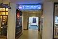
Main Station entrance before escalator renovations
References
- ↑ "Red Line upgrades fare collection system" (Press release). Greater Cleveland Regional Transit Authority. 2009-08-05. Retrieved 2009-08-10.
- ↑ Van Tassel, David D., ed.; John J. Grabowski, ed. (1996). "Cleveland Union Terminal". The Encyclopedia of Cleveland History (2nd ed.). Bloomington: Indiana University Press. ISBN 0-253-33056-4. Retrieved 2007-01-01. Cite uses deprecated parameter
|coauthors=(help) - ↑ "About RTA: History of Public Transit in Greater Cleveland". RTA Website. Retrieved 2007-06-26.
- ↑ Ginger Christ (2016-07-29). "Westbound RTA passengers to use new Tower City entrance starting Sunday". Cleveland Plain Dealer. Retrieved 2016-08-05.
- ↑ Ginger Christ (2016-08-01). "RTA passengers begin using new Tower City entrance". Cleveland Plain Dealer. Retrieved 2016-08-05.
- ↑ "Rail Riders - Track 8 Returns to Full Service". Greater Cleveland Regional Transit Authority. 2016-11-26. Retrieved 2016-12-04.
External links
| Wikimedia Commons has media related to Tower City–Public Square (RTA Rapid Transit station). |
- Photos of Tower City Station from Subway Nut
- Huron Road entrance from Google Maps Street View
- Prospect Street entrance from Google Maps Street View
Coordinates: 41°29′52″N 81°41′38″W / 41.4977°N 81.6939°W