Toft, Lincolnshire
| Toft | |
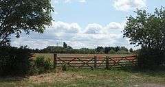 Field in Toft |
|
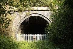 Eastern portal of Toft Tunnel[1] |
|
 Toft |
|
| Population | 333 (2011) |
|---|---|
| OS grid reference | TF069172 |
| – London | 90 mi (140 km) S |
| Civil parish | Toft with Lound and Manthorpe |
| District | South Kesteven |
| Shire county | Lincolnshire |
| Region | East Midlands |
| Country | England |
| Sovereign state | United Kingdom |
| Post town | Bourne |
| Postcode district | PE10 |
| Dialling code | 01778 |
| Police | Lincolnshire |
| Fire | Lincolnshire |
| Ambulance | East Midlands |
| EU Parliament | East Midlands |
| UK Parliament | Grantham and Stamford |
|
|
Coordinates: 52°44′32″N 0°24′54″W / 52.7423°N 0.4151°W
Toft is a small village in the South Kesteven district of Lincolnshire, England. It is situated approximately 2 miles (3 km) south-west from Bourne on the A6121. Toft is part of the civil parish of Toft with Lound and Manthorpe.[2] The population of the civil parish at the 2011 census was 333.[3]
The village gave its name to the Toft Tunnel on the former Midland and Great Northern Joint Railway (closed in 1959), which ran about 1 mile (1.6 km) to the north. This was the only tunnel on that railway, which ran for the most part over the Fens. The tunnel is actually in Lound, though still in the parish. It is now managed as a nature reserve[4]
Toft Hotel Golf Course is on the southern edge of the village. The East Glen river flows through the village, also to the south.
The north of the parish includes the Deserted medieval village of Bowthorpe, now a single farm, which gives its name to the Bowthorpe Oak.[5]
References
- ↑ Squires, Stewart; Hollamby, Ken, eds. (2009). Building a Railway: Bourne to Saxby. Lincoln Record Society. ISBN 978-0-9015038-62.
- ↑ "Toft cum Lound and Manthorpe". Lincolnshire Parish Councils | South Kesteven. Lincolnshire county council. Retrieved 20 May 2013.
- ↑ "Civil Parish population 2011". Neighbourhood Statistics. Offuice for National Statistics. Retrieved 23 May 2016.
- ↑ Smith, Jonathan (1997). "A short history of Toft Tunnel". LWT Nature Reserves. Lincolnshire Wildlife Trust. Retrieved 20 May 2013.
- ↑ Historic England. "Bowthorpe (348176)". PastScape. Retrieved 20 May 2013.
External links
 Media related to Toft, Lincolnshire at Wikimedia Commons
- Cork, Sue (2013). A History of Manthorpe, Toft and Lound (A4 comb bound). Bantry House, Manthorpe, tel 01778 590204: Witham-on-the-Hill Historical Society. Retrieved 20 May 2013.
- "Toft and Lound". Villages around Bourne. Rex Needle. 1997. Retrieved 20 May 2013.
- "History of Toft, in South Kesteven and Lincolnshire". A Vision of Britain through Time. GB Historical GIS / University of Portsmouth. Retrieved 20 May 2013.
England Portal | |
| Unitary authorities | |
| Boroughs or districts | |
| Major settlements |
|
| Topics | |