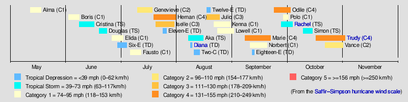
Timeline of the 1990 Pacific hurricane season
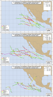
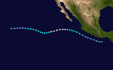
The 1990 Pacific hurricane season saw a then-record 16 hurricanes form.[1] Throughout the year, 21 tropical cyclones became named storms in the eastern Pacific Ocean. Hurricane Alma formed on May 12, 1990, three days before the season's official start on May 15. The Central Pacific hurricane season began on June 1, covering tropical cyclone formation in the region between 140°W and International Dateline. Hurricane Trudy was the last storm to dissipate, doing so on November 1, nearly a month before the Pacific hurricane season officially ended on November 30.[2]
The season produced twenty-seven tropical depressions, of which twenty-one became named storms, and sixteen strengthened into hurricanes. Six out of the sixteen hurricanes strengthened into major hurricanes.[nb 1] Despite high levels of activity, Rachel was the only system to make landfall, bringing floods to Northwestern Mexico and the Southwestern United States.[1] Thousands were left homeless, and there were 18 confirmed fatalities.[4] Additionally, the remnants of Hurricane Boris brought light showers to California. At that time, Hurricane Hernan was the strongest Pacific hurricane to have its intensity estimated via satellite imagery; this record was matched by Hurricane Trudy months later.[1] One tropical storm formed in the Central Pacific Hurricane Center's warning zone and eventually crossed the International Dateline before dissipating.[5]
This timeline includes information that was not operationally released, meaning that data from post-storm reviews by the National Hurricane Center, such as a storm that was not operationally warned upon, has been included. This timeline documents tropical cyclone formations, strengthening, weakening, landfalls, and dissipations during the season.
Timeline of events
May
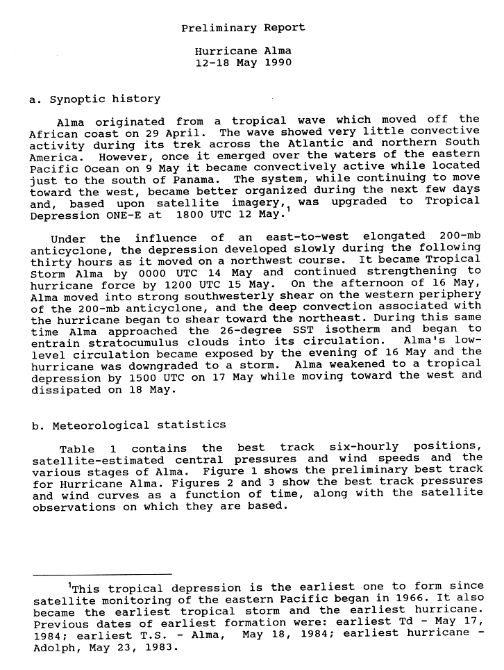
- May 12
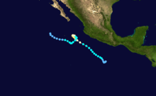
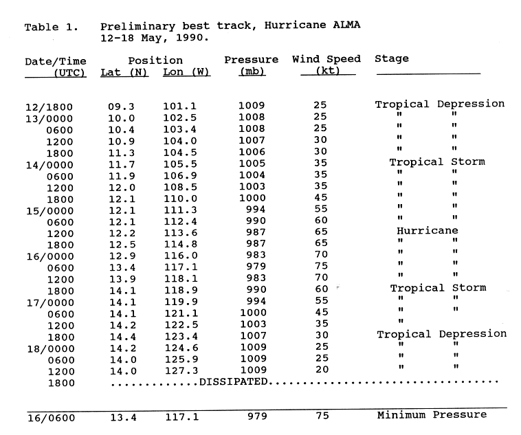
- 1800 UTC (11 a.m. PDT) – Tropical Depression One-E develops from a tropical wave while located about 580 mi (935 km)[nb 2] south of Zihuatanejo, Guerrero.[7][8]
- May 13
- 1800 UTC (11 a.m. PDT) – Tropical Depression One-E strengthens into Tropical Storm Alma, becoming an off-season tropical cyclone.[7]
- May 15
- 0000 UTC (5 p.m. PDT May 14) – The 1990 Pacific hurricane season officially begins.[2]
- 1200 UTC (5 a.m. PDT) – Tropical Storm Alma strengthens into a Category 1 hurricane.[7]
- May 16
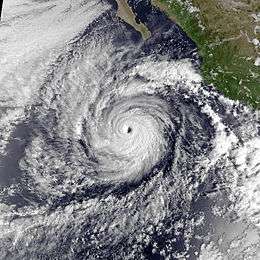
- 0600 UTC (11 p.m. PDT May 15) – Hurricane Alma attains its peak intensity with maximum sustained winds of 85 mph (140 km/h) and a minimum barometric pressure of 979 mbar (28.9 inHg).[7]
- 1800 UTC (11 a.m. PDT) – Hurricane Alma weakens to a tropical storm.[7]
- May 17
- 1800 UTC (11 a.m. PDT) – Tropical Storm Alma weakens to a tropical depression.[7]
- May 18
- 1800 UTC (11 a.m. PDT) – Tropical Depression Alma dissipates while centered about 1,445 mi (2,325 km) southwest of San Diego, California.[7]
June
- June 1
- 0000 UTC (5 p.m. PDT) – The 1990 Central Pacific hurricane season officially begins.[2]
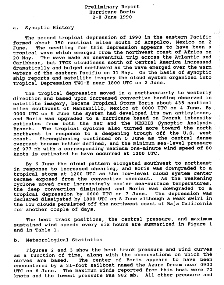
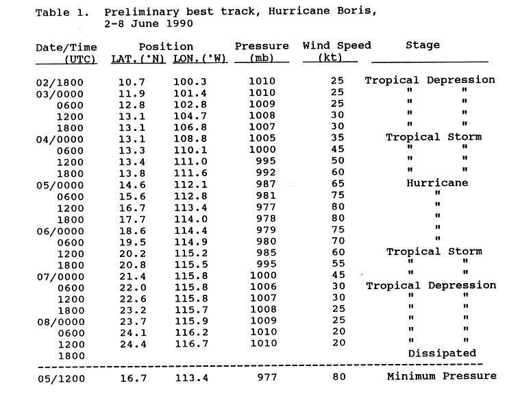
- June 2
- 1800 UTC (11 a.m. PDT) – Tropical Depression Two-E develops from a tropical wave while located about 430 mi (690 km) south of Acapulco, Guerrero.[9][10]
- June 4
- 0000 UTC (5 p.m. PDT June 3) – The depression strengthens into Tropical Storm Boris.[10]
- June 5
- 0000 UTC (5 p.m. PDT June 4) – Tropical Storm Boris strengthens into a Category 1 hurricane.[10]
- 1200 UTC (5 a.m. PDT) – Hurricane Boris attains its peak intensity with maximum sustained winds of 90 mph (150 km/h) and a minimum pressure of 977 mbar (28.9 inHg).[10]
- June 6
- 1200 UTC (5 a.m. PDT) – Hurricane Boris weakens back into a tropical storm.[10]
- June 7
- 0600 UTC (11 p.m. PDT June 6) – The NHC downgrades Tropical Storm Boris into a tropical depression.[10]
- June 8
- 1200U UTC (5 a.m. PDT) – Tropical Depression Three-E develops from a tropical wave located about 800 mi (1,300 km) south of the southern tip of Baja California Sur.[11][12]
- 1800 UTC (11 a.m. PDT) – Tropical Depression Boris dissipates about 400 mi (640 km) west of La Paz, Baja California Sur.[10]
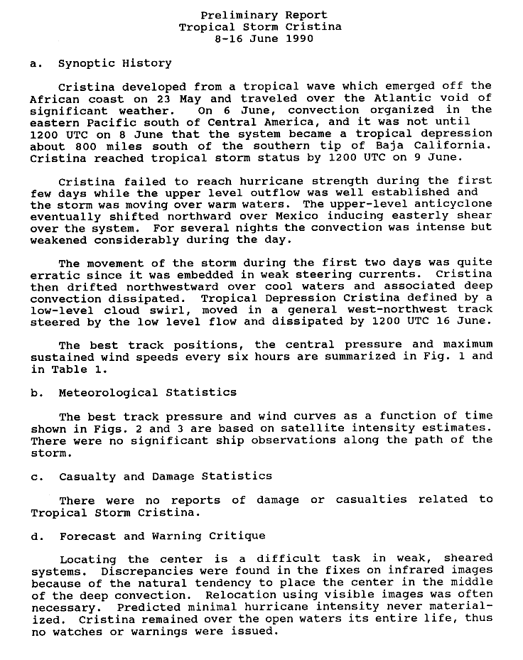
- June 9
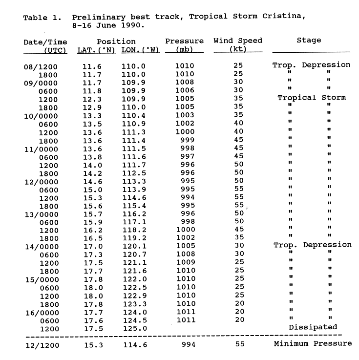
- 1200 UTC (5 a.m. PDT) – The tropical depression intensifies into Tropical Storm Cristina.[12]
- June 12
- 1200 UTC (5 a.m. PDT) – Tropical Storm Cristina reaches its peak intensity with maximum sustained winds of 65 mph (100 km/h) and a minimum barometric pressure of 994 mbar (29.4 inHg).[12]
- June 14
- 0000 UTC (5 p.m. PDT June 13) – Tropical Storm Cristina weakens to a tropical depression.[12]
- 1200 UTC (5 a.m. PDT) – Tropical Depression Cristina dissipates about 880 mi (1,420 km) southwest of Guadalupe Island.[12]
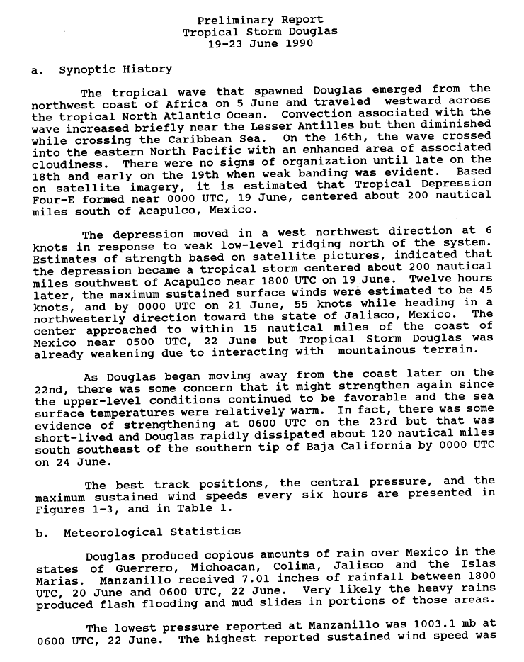
- June 19
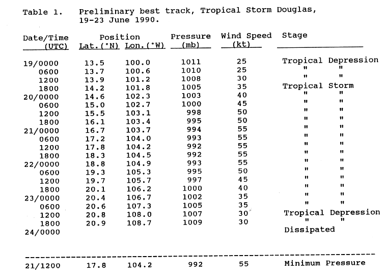
- 0000 UTC (5 p.m. PDT June 18) – Tropical Depression Four-E develops from a tropical wave while located about 230 mi (370 km) south of Acapulco.[13][14]
- 1800 UTC (11 a.m. PDT) – Tropical Depression Four strengthens into Tropical Storm Douglas.[14]
- June 21
- 1200 UTC (5 a.m. PDT) – Tropical Storm Douglas attains its peak intensity with maximum sustained winds of 65 mph (100 km/h) and a minimum pressure of 992 mbar (29.3 inHg).[14]
- June 23
- 1200 UTC (5 a.m. PDT) – Tropical Storm Douglas weakens to a tropical depression.[14]
- June 24
- 0000 UTC (5 p.m. PDT June 23) – Tropical Depression Douglas dissipates about 140 mi (230 km) south-southeast of the southern tip of Baja California.[14]
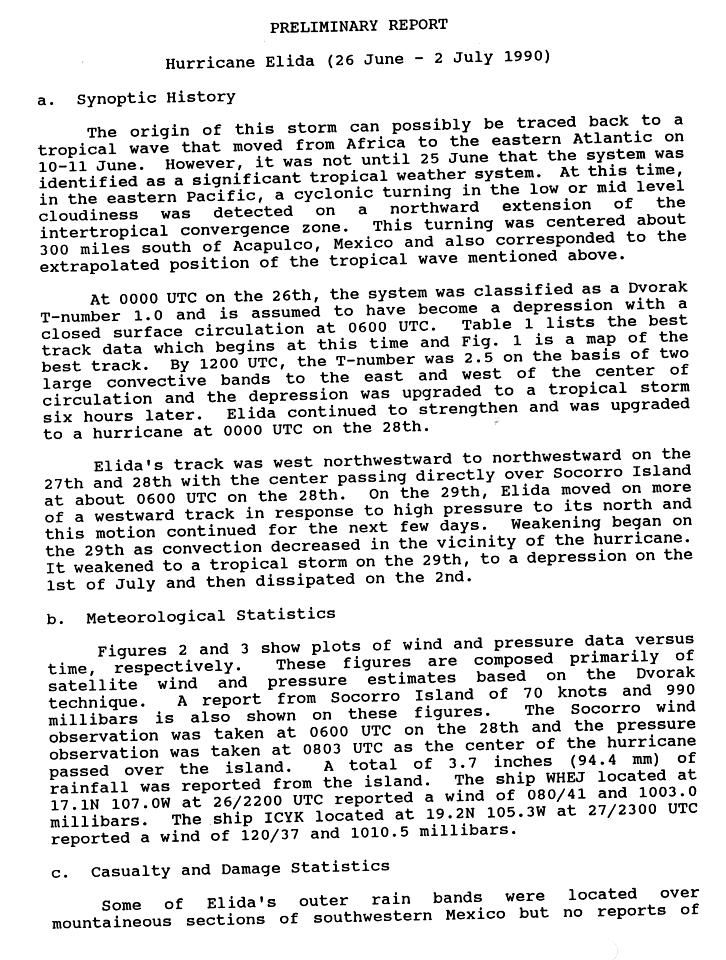
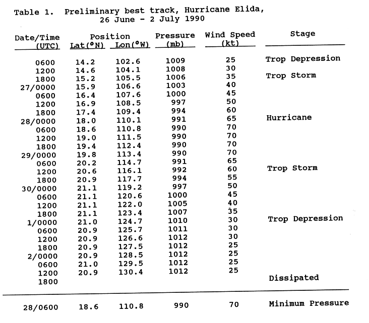
- June 26
- 0600 UTC (11 p.m. PDT June 25) – Tropical Depression Five-E forms about 345 mi (555 km) south of Acapulco.[15][16]
- 1800 UTC (11 a.m. PDT) – Tropical Depression Five-E strengthens into Tropical Storm Elida.[16]
- June 28
- 0000 UTC (5 p.m. PDT June 27) – Tropical Storm Elida becomes a Category 1 hurricane.[16]
- 0600 UTC (11 p.m. PDT June 27) – Hurricane Elida attains its peak intensity with maximum sustained winds of 80 mph (130 km/h) and a minimum barometric pressure of 990 mbar (29 inHg). Simultaneously, Elida crosses over Socorro Island.[16]
- June 29
- 1200 UTC (5 a.m. PDT) – Hurricane Elida weakens to a tropical storm.[16]
- 1800 UTC (11 a.m. PDT) – Tropical Depression Six-E develops about 890 mi (1,430 km) south of Acapulco.[17]
July
- July 1
- 0000 UTC (5 p.m. PDT June 31) – Tropical Storm Elida weakens into a tropical depression.[16]
- July 2
- 1800 UTC (11 a.m. PDT) – Tropical Depression Elida dissipates about 945 mi (1,520 km) southwest of Guadalupe Island.[16]
- July 3
- 1800 UTC (11 a.m. PDT) – Tropical Depression Six-E dissipates while centered about 160 mi (260 km) east of Socorro Island.[17]
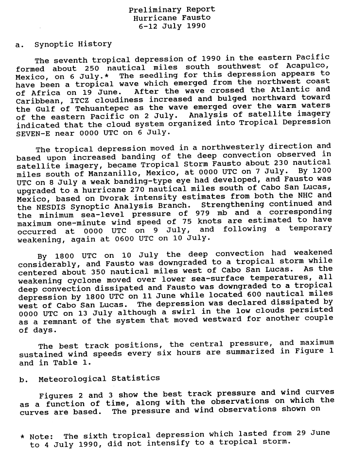
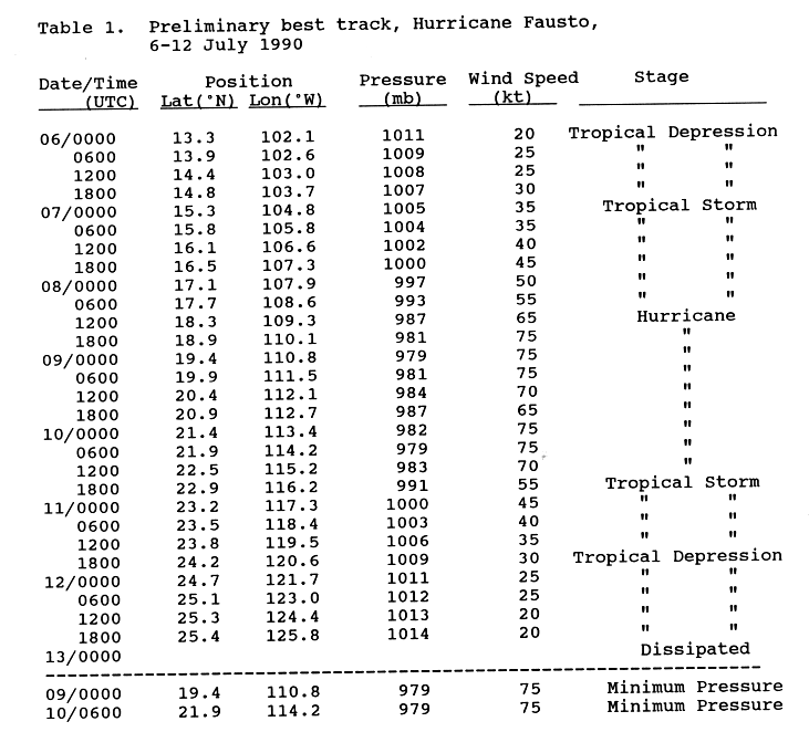
- July 6
- 0000 UTC (5 p.m. PDT July 5) – Tropical Depression Seven-E develops about 290 mi (470 km) southwest of Acapulco.[18][19]
- July 7
- 0000 UTC (5 p.m. PDT July 6) – Tropical Depression Seven-E strengthens into Tropical Storm Fausto.[19]
- July 8
- 1200 UTC (5 a.m. PDT) – The NHC upgrades Tropical Storm Fausto into a Category 1 hurricane.[19]
- July 9
- 0000 UTC (5 p.m. PDT July 8) – Hurricane Fausto attains its peak intensity with maximum sustained winds of 85 mph (140 km/h) and a minimum barometric pressure of 979 mbar (28.9 inHg).[19]
- July 10
- 0000 UTC (5 p.m. PDT July 9) – Tropical Depression Eight-E develops from a tropical wave while located about 640 mi (1,030 km) west-northwest of Cabo Blanco, Costa Rica.[20][21]
- 0600 UTC (11 p.m. PDT July 9) – Hurricane Fausto again attains its peak intensity with winds of 85 mph (140 km/h) and a minimum pressure of 979 mbar (28.9 inHg).[19]
- 1800 UTC (11 a.m. PDT) – Hurricane Fausto weakens to a tropical storm.[19]
- July 11
- 1800 UTC (11 a.m. PDT) – Tropical Storm Fausto degenerates into a tropical depression.[19]
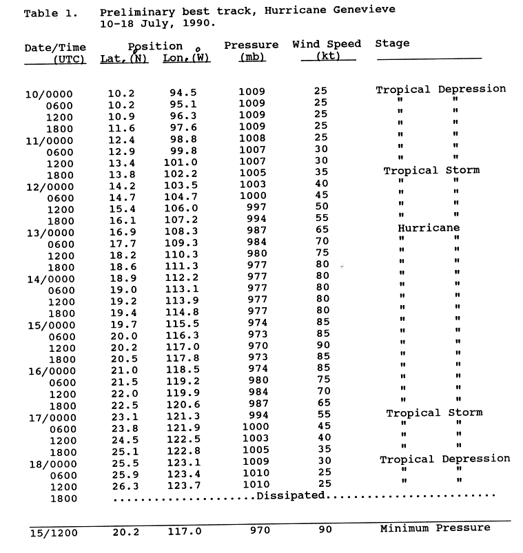
- 1800 UTC (11 a.m. PDT) – Tropical Depression Eight-E strengthens into Tropical Storm Genevieve.[21]

- July 13
- 0000 UTC (5 p.m. PDT July 12) – Tropical Depression Fausto dissipates about 750 mi (1,205 km) southwest of Los Angeles, California.[19]
- 0000 UTC (5 p.m. PDT July 12) – Tropical Storm Genevieve strengthens into a Category 1 hurricane.[21]
- July 15
- 0000 UTC (5 p.m. PDT July 14) – Hurricane Genevieve is upgraded into a Category 2 hurricane.[21]
- 1200 UTC (5 a.m. PDT) – Hurricane Genevieve attains its peak intensity with maximum sustained winds of 105 mph (165 km/h) and a minimum barometric pressure of 970 mbar (29 inHg).[21]
- July 16
- 0600 UTC (11 p.m. PDT July 15) – Hurricane Genevieve weakens back to a Category 1 hurricane.[21]
- July 17
- 0000 UTC (5 p.m. PDT July 16) – Hurricane Genevieve degenerates into a tropical storm.[21]
- July 18
- 0000 UTC (5 p.m. PDT July 17) – Tropical Storm Genevieve weakens to a tropical depression.[21]
- 1800 UTC (11 a.m. PDT) – Tropical Depression Genevieve dissipates about 380 mi (610 km) southwest of Guadalupe Island.[21]
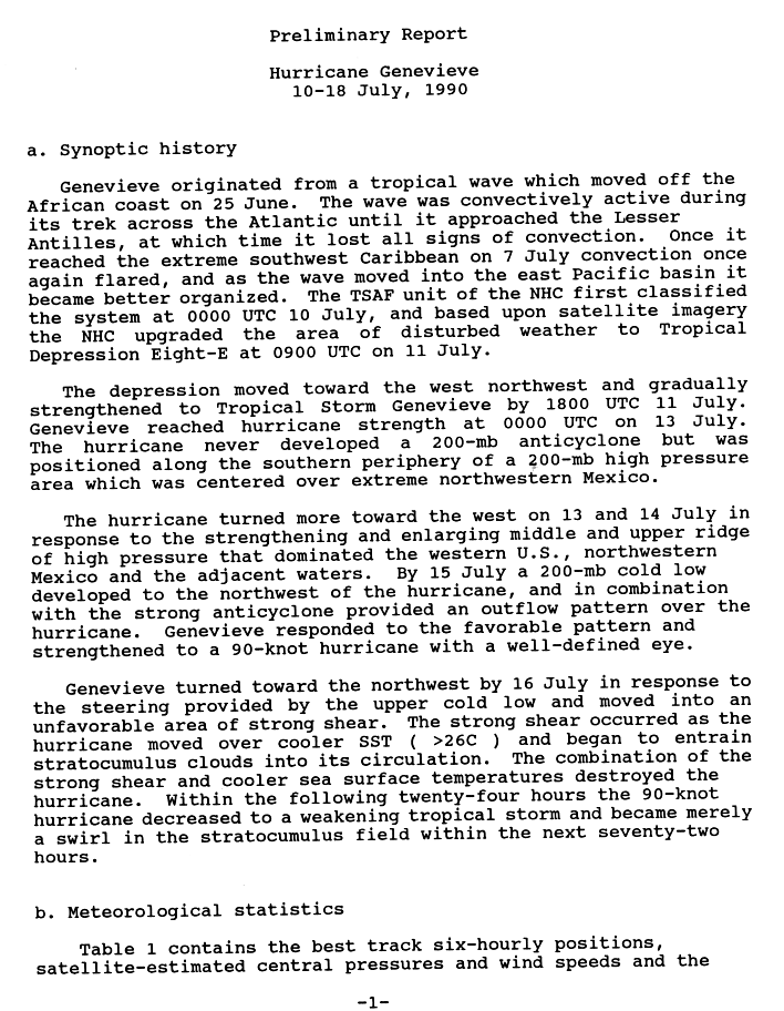
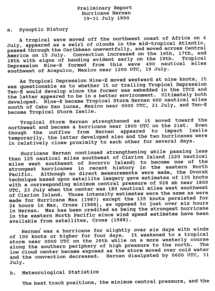
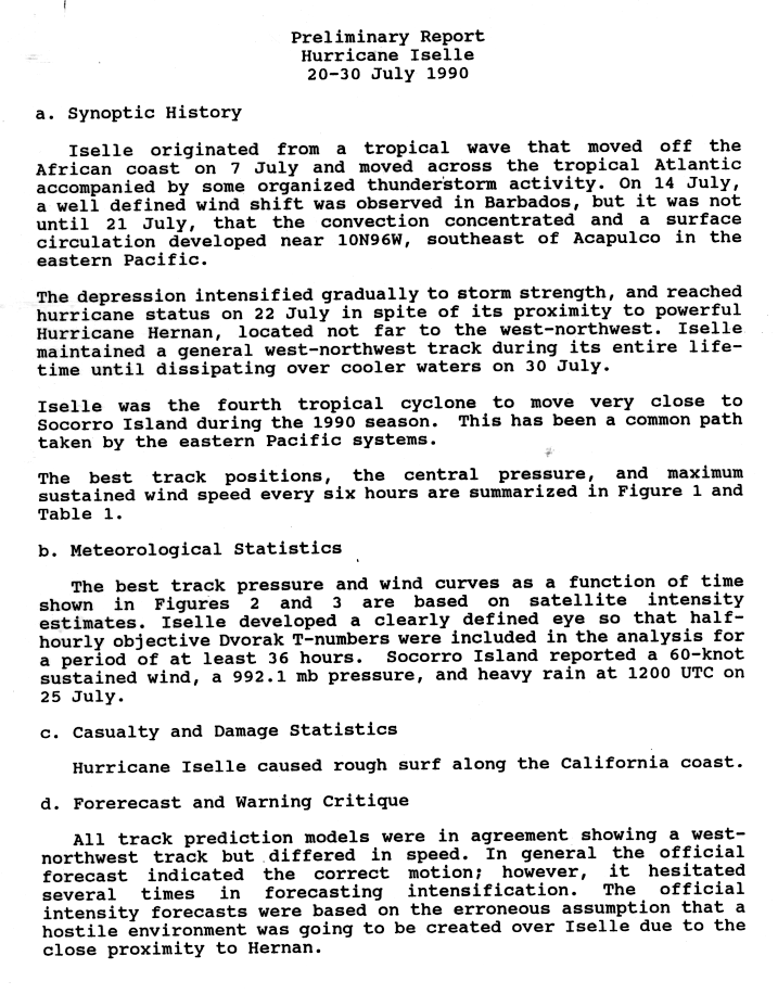
- July 19
- 1200 UTC (5 a.m. PDT) – Tropical Depression Nine-E develops from a tropical wave while located about 510 mi (820 km) southwest of Acapulco.[22][23]
- July 20
- 1200 UTC (5 a.m. PDT) – Tropical Depression Ten-E forms from a tropical wave while located about 395 mi (635 km) south of Puerto Ángel, Oaxaca.[24][25]
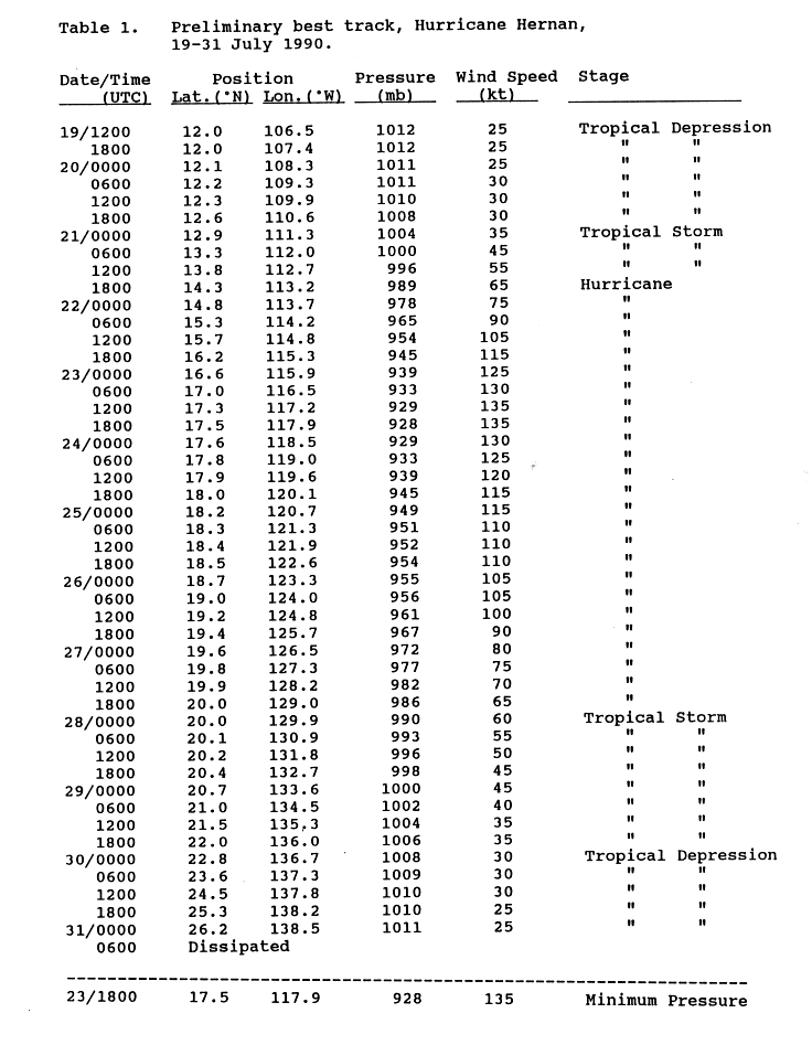
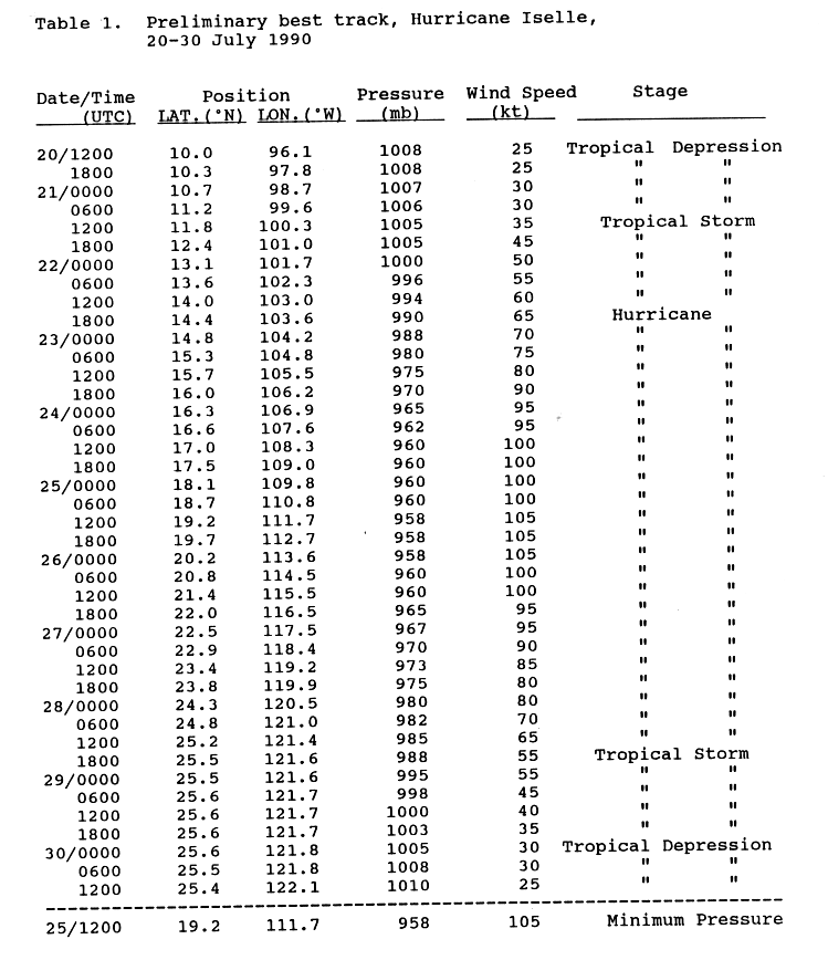
- July 21
- 0000 UTC (5 p.m. PDT July 20) – Tropical Depression Nine-E strengthens into Tropical Storm Hernan.[23]
- 1200 UTC (5 a.m. PDT) – Tropical Depression Ten-E strengthens into Tropical Storm Iselle.[25]
- 1800 UTC (11 a.m. PDT) – Tropical Storm Hernan strengthens into a Category 1 hurricane.[23]
- July 22
- 0600 UTC (11 p.m. PDT July 21) – Hurricane Hernan is upgraded into a Category 2 hurricane.[23]
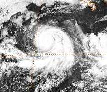
- 1200 UTC (5 a.m. PDT) – Hurricane Hernan intensifies into a Category 3 hurricane.[23]
- 1800 UTC (11 a.m. PDT) – Hurricane Hernan strengthens into a Category 4 hurricane.[23]
- 1800 UTC (11 a.m. PDT) – Tropical Storm Iselle intensifies into a Category 1 hurricane.[25]
- July 23
- 1800 UTC (11 a.m. PDT) – Hurricane Hernan attains its peak intensity with winds of 155 mph (250 km/h) and a minimum pressure of 928 mbar (27.4 inHg).[23]
- 1800 UTC (11 a.m. PDT) – Hurricane Iselle strengthens into a Category 2 hurricane.[25]

- July 24
- 0000 UTC (5 p.m. PDT July 23) – Tropical Depression Eleven-E develops about 1445 mi (2,325 km) west-southwest of the southern tip of the Baja California Peninsula.[17]
- 1200 UTC (5 a.m. PDT) – Hurricane Iselle strengthens into a Category 3 hurricane.[25]
- July 25
- 0600 UTC (11 p.m. PDT July 24) – Hurricane Hernan weakens to a Category 3 hurricane.[23]
- 1200 UTC (5 a.m. PDT) – Hurricane Iselle attains its peak intensity with maximum sustained winds of 120 mph (195 km/h) and a minimum barometric pressure of 958 mbar (28.3 inHg).[25]
- July 26
- 0600 UTC (11 p.m. PDT July 25) – Tropical Depression Eleven-E dissipates about 1,590 mi (2,560 km) east-southeast of Hilo, Hawaii.[17]
- 1800 UTC (11 a.m. PDT) – Hurricane Hernan weakens into a Category 2 hurricane.[23]
- July 27
- 0000 UTC (5 p.m. PDT July 26) – Hurricane Hernan weakens back to a Category 1 hurricane.[23]
- July 28
- 0000 UTC (5 p.m. PDT July 27) – Hurricane Hernan weakens to a tropical storm.[23]
- July 30
- 0000 UTC (5 p.m. PDT July 29) – Tropical Storm Hernan weakens to a tropical depression.[23]
- July 31
- 0600 UTC (11 p.m. PDT July 30) – Tropical Depression Hernan dissipates midway between Honolulu, Hawaii and Guadalupe Island.[23]
August
- August 7
- 1800 UTC (9 a.m. HST) – Tropical Depression One-C develops from an area of disturbed weather while located about 695 mi (1,120 km) south-southeast of Ka Lae, Hawaii.[5]
- August 8
- 0000 UTC (3 p.m. HST August 7) – Tropical Depression One-C strengthens into Tropical Storm Aka.[5]
- 1200 UTC (3 a.m. HST) – Tropical Storm Aka attains its peak intensity with maximum sustained winds of 65 mph (100 km/h), though the minimum pressure is unknown.[5]
- August 10
- 1800 UTC (9 a.m. HST) – Tropical Depression Two-C develops from a tropical disturbance while located about 1,030 mi (1,660 km) east-southeast of Hilo.[5]

- August 13
- 0000 UTC (3 p.m. HST August 12) – Tropical Depression Two-C dissipates about 600 mi (965 km) south-southeast of Hilo.[5]
- 0600 UTC (9 p.m. HST August 12) – Tropical Storm Aka crossed the International Dateline.[5]
- August 16
- 1200 UTC (5 a.m. PDT) – Tropical Depression Twelve-E forms about 155 mi (250 km) west-northwest of Clipperton Island.[17]
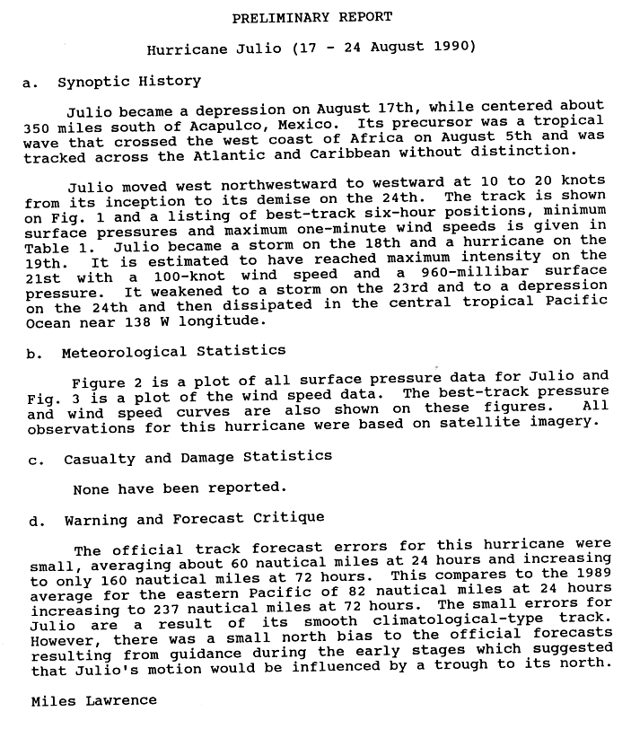
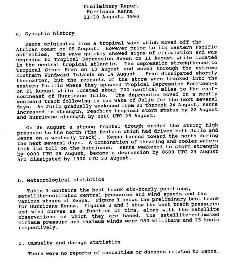
- August 17
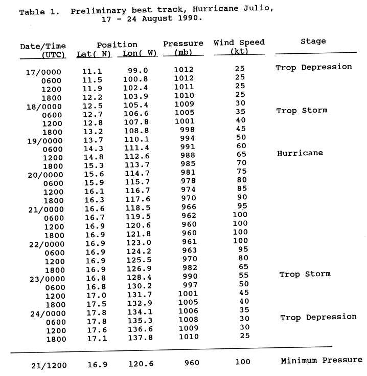
- 0000 UTC (5 p.m. PDT August 16) – Tropical Depression Thirteen-E forms about 350 mi (560 km) south of Acapulco.[26][27]
- August 18
- 1200 UTC (5 a.m. PDT) – Tropical Depression Thirteen-E strengthens into Tropical Storm Julio.[27]
- August 19
- 1200 UTC (5 a.m. PDT) – The NHC upgrades Tropical Storm Julio into a Category 1 hurricane.[27]
- 1200 UTC (5 a.m. PDT) – Tropical Depression Twelve-E dissipates about 1,180 mi (1,900 km) southwest of Guadalupe Island.[17]
- August 20
- 1200 UTC (5 a.m. PDT) – Hurricane Julio strengthens into a Category 2 hurricane.[27]
- August 21
- 0600 UTC (11 p.m. PDT August 20) – Hurricane Julio is upgraded into a Category 3 hurricane.[27]
- 1200 UTC (5 a.m. PDT) – Hurricane Julio attains its peak intensity with winds of 115 mph (185 km/h) and a minimum pressure of 960 mbar (28 inHg).[27]
- 1800 UTC (11 a.m PDT) – Tropical Depression Fourteen-E develops from a tropical wave while located about 330 mi (530 km) south of Socorro Island.[28][29]
- August 22
- 0600 UTC (11 p.m. PDT August 21) – Hurricane Julio weakens to a Category 2 hurricane.[27]
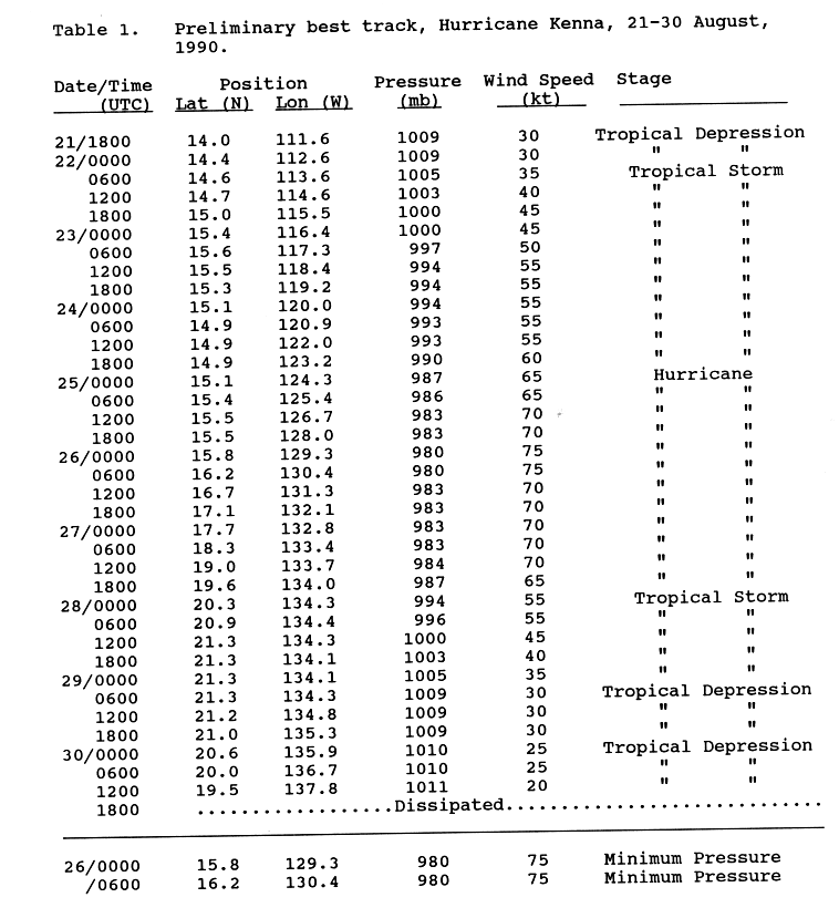
- 0600 UTC (11 p.m. PDT August 21) – Tropical Depression Fourteen-E strengthens into Tropical Storm Kenna.[29]
- 1200 UTC (5 a.m. PDT) – Hurricane Julio weakens to a Category 1 hurricane.[27]
- August 23
- 0000 UTC (5 p.m. PDT August 22) – Hurricane Julio weakens to a tropical storm.[27]
- 1800 UTC (11 a.m. PDT) – Tropical Depression Fifteen-E develops from a tropical wave while located about 115 mi (185 km) south of Puerto Ángel.[30][30]
- August 24
- 0600 UTC (11 p.m. PDT August 23) – Tropical Storm Julio weakens to a tropical depression.[27]
- 1800 UTC (11 a.m. PDT) – Tropical Depression Julio dissipates about 1,150 mi (1,850 km) east-southeast of Hilo, Hawaii.[27]
- August 25
- 0000 UTC (5 p.m. PDT August 24) – Tropical Storm Kenna intensifies into a Category 1 hurricane.[29]
- 1800 UTC (11 a.m. PDT) – Tropical Depression Fifteen-E strengthens into Tropical Storm Lowell.[30]
- August 26
- 0000 UTC (5 p.m. PDT August 25) – Hurricane Kenna attains its peak intensity with maximum sustained winds of 85 mph (140 km/h) and a minimum barometric pressure of 980 mbar (29 inHg).[29]
- August 27
- 0600 UTC (11 p.m. PDT August 26) – Tropical Storm Lowell strengthens into a Category 1 hurricane.[30]
- August 28
- 0000 UTC (5 p.m. PDT August 27) – Hurricane Kenna weakens to a tropical storm.[29]
- 0000 UTC (5 p.m. PDT August 27) – Hurricane Lowell attains its peak intensity with winds of 75 mph (120 km/h) and a minimum pressure of 986 mbar (29.1 inHg).[30]
- 1800 UTC (11 a.m. PDT) – Hurricane Lowell weakens to a tropical storm.[30]
- August 29
- 0600 UTC (11 p.m. PDT August 28) – Tropical Storm Kenna weakens to a tropical depression.[29]
- August 30
- 1800 UTC (11 a.m. PDT) – Tropical Depression Kenna dissipates about 1,125 mi (1,810 km) east of Hilo.[29]
- August 31
- 1200 UTC (5 a.m. PDT) – Tropical Storm Lowell weakens to a tropical depression.[30]
September
- September 1
- 1800 UTC (11 a.m. PDT) – Tropical Depression Lowell dissipates about 1,230 mi (1,980 km) east of Hilo.[30]
- September 7
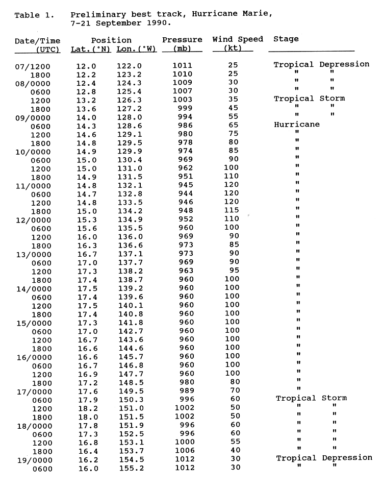
- 1200 UTC (5 a.m. PDT) – Tropical Depression Sixteen-E originates from a tropical wave while situated about 870 mi (1,400 km) southwest of Socorro Island.[31][32]
- September 8
- 1200 UTC (5 a.m. PDT) – Tropical Depression Sixteen-E strengthens into Tropical Storm Marie.[32]
- September 9
- 0600 UTC (11 p.m. PDT September 8) – Tropical Storm Marie is upgraded into a Category 1 hurricane.[32]
- 1800 UTC (11 a.m. PDT) – Tropical Depression Eighteen-E forms about 225 mi (360 km) southwest of Acapulco.[17]
- September 10
- 0000 UTC (5 p.m. PDT September 9) – Hurricane Marie strengthens into a Category 2 hurricane.[32]
- 0000 UTC (5 p.m. PDT September 9) – Tropical Depression Seventeen-E develops from a tropical wave while located about 455 mi (730 km) south-southwest of Socorro Island.[33][34]
- 1200 UTC (5 a.m. PDT) – Hurricane Marie strengthens into a Category 3 hurricane.[32]
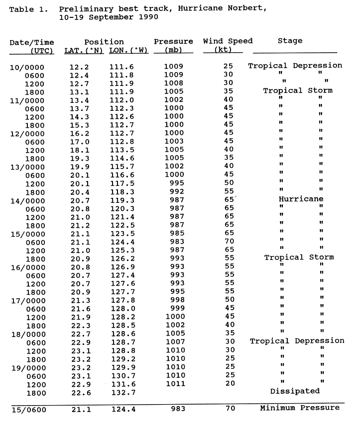
- 1800 UTC (11 a.m. PDT) – Tropical Depression Seventeen-E strengthens into Tropical Storm Norbert.[34]
- September 11
- 0000 UTC (5 p.m. PDT September 10) – Hurricane Marie strengthens into a Category 4 hurricane.[32]
- 0300 UTC (8 p.m. PDT September 10) – Hurricane Marie attains its peak intensity with winds of 140 mph (220 km/h) and a minimum pressure of 944 mbar (27.9 inHg).[32]
- September 12
- 0000 UTC (5 p.m. PDT September 11) – Hurricane Marie weakens to a Category 3 hurricane.[32]
- 1200 UTC (5 a.m.PDT) – Hurricane Marie weakens to a Category 2 hurricane.[32]
- 1800 UTC (11 a.m. PDT) – Tropical Depression Eighteen-E dissipates about 30 mi (50 km) northwest of Clarion Island.[17]
- September 13
- 1800 UTC (11 a.m. PDT) – Hurricane Marie regains Category 3 hurricane strength.[32]
- September 14
- 0000 UTC (5 p.m. PDT September 13) – Tropical Storm Norbert strengthens into a Category 1 hurricane.[34]
- 1200 UTC (3 a.m. HST) – Hurricane Marie moves into the Central Pacific Hurricane Center's area of responsibility.[5]
- September 15
- 0600 UTC (11 p.m. PDT September 14) – Hurricane Norbert attains its peak intensity with maximum sustained winds of 80 mph (130 km/h) and a minimum barometric pressure of 983 mbar (29.0 inHg).[34]
- 1800 UTC (11 a.m. PDT) – Hurricane Norbert weakens to a tropical storm.[34]
- September 16
- 1800 UTC (9 a.m. HST) – Hurricane Marie rapidly weakens into a Category 1 hurricane.[5]
- September 17
- 0600 UTC (9 p.m. HST September 16) – Hurricane Marie weakens back to tropical storm status.[5]
- September 18
- 0600 UTC (11 p.m. PDT September 17) – Tropical Storm Norbert weakens to a tropical depression.[34]
- September 19
- 0000 UTC (3 p.m. HST September 18) – Tropical Storm Marie weakens to a tropical depression.[5]
- 1800 UTC (11 a.m. PDT) – Tropical Depression Norbert dissipates about 1,165 mi (1,875 km) southwest of San Francisco, California.[34]
- September 21
- 0000 UTC (3 p.m. HST September 20) – Tropical Depression Marie dies about 400 mi (640 km) south-southwest of Honolulu, Hawaii.[5]
- September 23
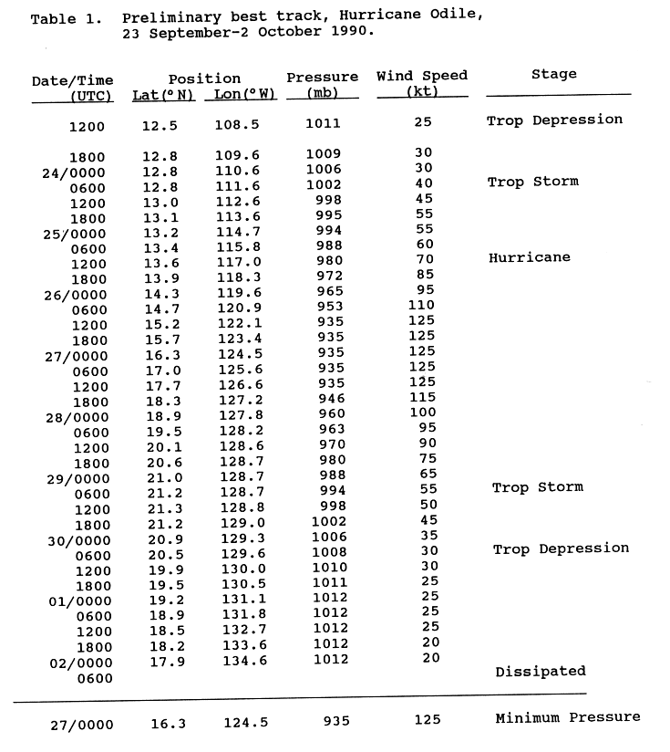
- 1200 UTC (5 a.m. PDT) – Tropical Depression Nineteen-E develops from an area of disturbed weather while located approximately 565 mi (910 km) south-southeast of Socorro Island.[35][36]
- September 24
- 0600 UTC (11 p.m. PDT September 23) – Tropical Depression Nineteen-E strengthens into Tropical Storm Odile.[36]
- September 25
- 1200 UTC (5 a.m. PDT) – Tropical Storm Odile intensifies into a Category 1 hurricane.[36]
- 1800 UTC (11 a.m. PDT) – Hurricane Odile strengthens into a Category 2 hurricane.[36]
- September 26
- 0600 UTC (11 p.m. PDT September 25) – Hurricane Odile strengthens into a Category 3 hurricane.[36]
- 1200 UTC (5 a.m. PDT) – Hurricane Odile strengthens into a Category 4 hurricane. Simultaneously, Odile attains its peak intensity with maximum sustained winds of 145 mph (230 km/h) and a minimum barometric pressure of 935 mbar (27.6 inHg).[36]
- September 27
- 0000 UTC (5 p.m. PDT September 26) – Tropical Depression Twenty-E develops from a tropical wave while centered about 235 mi (380 km) south of Acapulco.[37][38]
- September 28
- 0000 UTC (5 p.m. PDT September 27) – Hurricane Odile weakens to a Category 3 hurricane.[36]
- 0600 UTC (11 p.m. PDT September 27) – Hurricane Odile weakens to a Category 2 hurricane.[36]
- 1800 UTC (11 a.m. PDT) – Hurricane Odile weakens to a Category 1 hurricane.[36]
- 2100 UTC (2 p.m. PDT) – Tropical Depression Twenty-E develops from a tropical wave located about east of 1,390 mi (2,240 km) Hilo, Hawaii.[39]
- September 29
- 0600 UTC (11 p.m. PDT September 28) – Hurricane Odile weakens to a tropical storm.[36]
- 1800 UTC (11 a.m. PDT) – Tropical Depression Twenty-E strengthens into Tropical Storm Polo.[39]
- September 30
- 0600 UTC (11 p.m. PDT September 29) – Tropical Storm Odile weakens back to a tropical depression.[36]
- 0600 UTC (11 p.m. PDT September 29) – Tropical Storm Polo strengthens into a Category 1 hurricane.[39] Simultaneously, Polo peaks in intensity with maximum sustained winds of 75 mph (120 km/h) and a minimum barometric pressure of 987 mbar (29.1 inHg).[39]
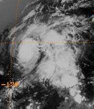
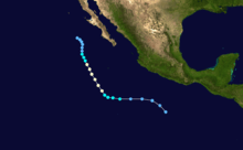
- 0600 UTC (11 p.m. PDT September 29) – Tropical Depression Twenty One-E strengthens into Tropical Storm Rachel.[38]
- 1800 UTC (11 a.m. PDT) – Hurricane Polo weakens to a tropical storm.[39]
October
- October 1
- 0000 UTC (3 p.m. HST September 30) – Tropical Storm Polo enters the Central Pacific Hurricane Center's area of responsibility.[5]
- 1200 UTC (3 a.m. HST) – Tropical Storm Polo weakens to a tropical depression.[5]
- 1800 UTC (9 a.m. HST) – Tropical Depression Polo ceases to exist as a tropical cyclone about 820 mi (1,320 km) east-southeast of Hilo, Hawaii.[5]
- October 2
- 0600 UTC (11 p.m. PDT October 1) – Tropical Depression Odile dissipates about 1,380 mi (2,220 km) east of Ka Lae, Hawaii.[36]
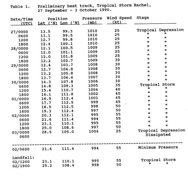
- 0600 UTC (11 p.m. PDT October 1) – Tropical Storm Rachel attains its peak intensity with maximum sustained winds of 65 mph (100 km/h) and a minimum barometric pressure of 944 mbar (27.9 inHg).[38]
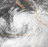
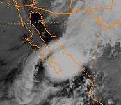
- 1200 UTC (5 a.m. PDT) – Tropical Storm Rachel moves over the southern tip of Baja California Sur with winds of 65 mph (100 km/h).[38]
- 1900 UTC (12 p.m. PDT) – Tropical Storm Rachel makes another landfall roughly midway between Los Mochis and Culiacán, Sinaloa with winds of 60 mph (90 km/h).[38]
- October 3
- 0000 UTC (5 p.m. PDT October 2) – Now over land, Tropical Storm Rachel is downgraded a tropical depression.[38]
- 0600 UTC (11 p.m. PDT October 2) – Tropical Depression Rachel dissipates over Chihuahua.[38]
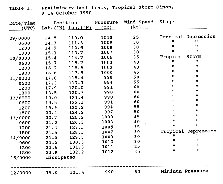
- October 9
- 0000 UTC (5 p.m. PDT October 8) – Tropical Depression Twenty Two-E develops from a tropical wave while located about 300 mi (485 km) south of Socorro Island.[40][41]
- October 10
- 0000 UTC (5 p.m. PDT October 9) – Tropical Depression Twenty Two-E becomes Tropical Storm Simon.[41]
- October 11
- 1800 UTC (11 a.m. PDT) – Tropical Storm Simon attains its peak intensity with winds of 70 mph (110 km/h) and a minimum pressure of 990 mbar (29 inHg).[41]
- October 13
- 1800 UTC (11 a.m. PDT) – Tropical Storm Simon weakens into a tropical depression.[41]
- October 15
- 0000 UTC (5 p.m. PDT October 14) – Tropical Depression Simon dissipates about 1,195 mi (1,925 km) southwest of Los Angeles, California.[41]
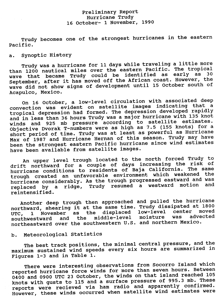
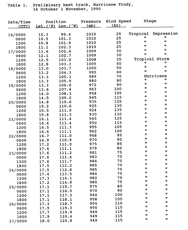
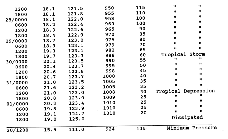
- October 16
- 0000 UTC (5 p.m. PDT October 15) – Tropical Depression Twenty Three-E formers from a tropical wave while located about 455 mi (730 km) south of Acapulco.[42][43]
- October 17
- 1200 UTC (5 a.m. PDT) – Tropical Depression Twenty Three-E strengthens into Tropical Storm Trudy.[43]
- October 18
- 1200 UTC (5 a.m. PDT) – Tropical Storm Trudy strengthens into a Category 1 hurricane.[43]
- October 19
- 0000 UTC (5 p.m. PDT October 18) – Hurricane Trudy strengthens into a Category 2 hurricane.[43]
- 0600 UTC (11 p.m. PDT October 18) – Hurricane Trudy strengthens into a Category 3 hurricane.[43]
- 1800 UTC (11 a.m. PDT) – Hurricane Trudy strengthens into a Category 4 hurricane.[43]
- October 20
- 1200 UTC (5 a.m. PDT) – Hurricane Trudy attains its peak intensity with winds of 155 mph (250 km/h).[43]
- October 21
- 1200 UTC (5 a.m. PDT) – Hurricane Trudy weakens back to a Category 3 hurricane.[43]
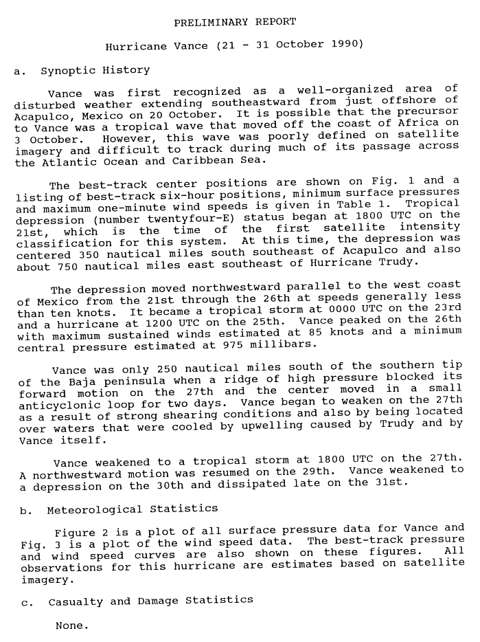
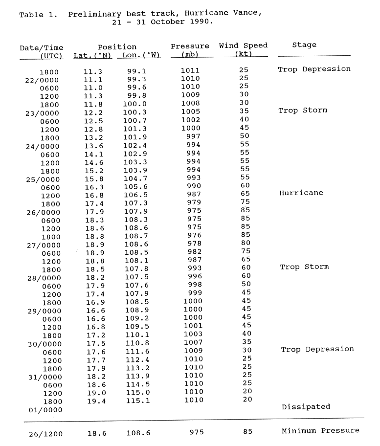
- 1800 UTC (11 a.m. PDT) – Tropical Depression Twenty Four-E develops from an area of disturbed weather while located about 380 mi (610 km) south of Acapulco.[44][45]
- October 22
- 0000 UTC (5 p.m. PDT October 21) – Hurricane Trudy weakens to a Category 2 hurricane.[43]
- 1800 UTC (11 a.m. PDT) – Hurricane Trudy weakens to a Category 1 hurricane.[43]
- October 23
- 0000 UTC (5 p.m. PDT October 22) – Tropical Depression Twenty Four-E strengthens into Tropical Storm Vance.[45]
- October 25
- 0000 UTC (5 p.m. PDT October 24) – Hurricane Trudy re-strengthens into a Category 2 hurricane.[43]
- 1200 UTC (5 a.m. PDT) – The NHC upgrades Hurricane Trudy into a Category 3 hurricane for a second time.[43]
- 1200 UTC (5 a.m. PDT) – Tropical Storm Vance strengthens into a Category 1 hurricane.[45]
- October 26
- 0000 UTC (5 p.m. PDT October 25) – Hurricane Vance intensifies into a Category 2 hurricane and attains its peak intensity with winds of 100 mph (155 km/h).[45]
- 0600 UTC (11 p.m. PDT October 25) – Hurricane Trudy re-strengthens into a Category 4 hurricane.[43]
- October 27
- 0000 UTC (5 p.m. PDT October 26) – Hurricane Vance weakens to a Category 1 hurricane.[45]
- 1800 UTC (11 a.m. PDT) – Hurricane Trudy weakens to a Category 3 hurricane.[46]
- 1800 UTC (11 a.m. PDT) – Hurricane Vance weakens to a tropical storm.[45]
- October 28
- 1200 UTC (5 a.m. PDT) – The NHC reports that Hurricane Trudy has weakened to a Category 2 hurricane.[46]
- October 29
- 0000 UTC (5 p.m. PDT October 28) – Hurricane Trudy weakens to a Category 1 hurricane.[46]
- 1800 UTC (11 a.m. PDT) – Hurricane Trudy weakens to a tropical storm.[46]
- October 30
- 0600 UTC (11 p.m. PDT October 29) – Tropical Storm Vance weakens back into a tropical depression.[45]
- October 31
- 1200 UTC (5 a.m. PDT) – Tropical Storm Trudy weakens to a tropical depression.[46]
November
- November 1
- 0000 UTC (5 p.m. PDT October 31) – Tropical Depression Vance dissipates about 700 mi (1,125 km) south of Guadalupe Island.[45]
- 1800 UTC (11 a.m. PDT) – Tropical Depression Trudy dissipates about 800 mi (1,285 km) southwest of Guadalupe Island.[46]
- November 30
- 2359 UTC (4:59 p.m. PDT) – The 1990 Pacific hurricane season officially ends.[2]
See also
- 1990 Pacific hurricane season
- List of Pacific hurricane seasons
- Timeline of the 1990 Atlantic hurricane season
- Timeline of the 1990–91 South Pacific cyclone season
Notes
- ↑ A major hurricane is a storm that ranks as Category 3 or higher on the Saffir–Simpson hurricane wind scale.[3]
- ↑ The figures for maximum sustained winds and position estimates are rounded to the nearest 5 units (knots, miles, or kilometers), following the convention used in the National Hurricane Center's operational products for each storm.[6] All other units are rounded to the nearest digit.
References
- 1 2 3 Lixion Avila (1990). "Eastern North Pacific Season of 1990" (PDF). Monthly Weather Review. National Hurricane Center. 119 (8): 2034. Bibcode:1991MWRv..119.2034A. doi:10.1175/1520-0493(1991)119<2034:ENPHSO>2.0.CO;2. ISSN 1520-0493. Retrieved December 20, 2006.
- 1 2 3 4 Chris Landsea and Neal Dorst (June 2, 2011). "G: Tropical Cyclone Climatology". Hurricane Research Division: Frequently Asked Questions. Atlantic Oceanographic and Meteorological Laboratory. National Oceanic and Atmospheric Administration. G1) When is hurricane season ?. Retrieved April 17, 2013.
- ↑ Chris Landsea; Neal Dorst (ed.) (June 2, 2011). "A: Basic Definitions". Hurricane Research Division: Frequently Asked Questions. Atlantic Oceanic and Meteorology Laboratory. National Oceanic and Atmospheric Administration. A3) What is a super-typhoon? What is a major hurricane ? What is an intense hurricane ?. Retrieved April 16, 2013.
- ↑ "Hurricane Klaus Downgraded". St. Louis Post-Dispatch. October 1, 1990.
- 1 2 3 4 5 6 7 8 9 10 11 12 13 14 15 The 1990 Central Pacific Tropical Cyclone Season. Central Pacific Hurricane Center (Report). Honolulu, Hawaii: National Oceanic and Atmoshperic Administration. May 4, 2007. Retrieved December 21, 2011.
- ↑ 2010 Tropical Cyclone Advisory Archive. National Hurricane Center (Archive). National Oceanic and Atmospheric Administration. February 7, 2009. Retrieved April 16, 2013.
- 1 2 3 4 5 6 7 Robert Case (1990). Preliminary best track, Hurricane Alma 12–15 May 1990 (GIF). National Hurricane Center (Report). Miami, Florida: National Oceanic and Atmospheric Administration. p. 3. Retrieved April 16, 2013.
- ↑ Robert Case (1990). Preliminary Report: Hurricane Alma (GIF). National Hurricane Center (Report). Miami, Florida: National Oceanic and Atmospheric Administration. p. 1. Retrieved April 16, 2013.
- ↑ Max Mayfield (1990). Preliminary Report: Hurricane Boris (GIF). National Hurricane Center (Report). Miami, Florida: National Oceanic and Atmospheric Administration. p. 1. Retrieved April 16, 2013.
- 1 2 3 4 5 6 7 Max Mayfield (1990). Preliminary best track, Hurricane Boris, 2–8 June 1990 (GIF). National Hurricane Center (Report). Miami, Florida: National Oceanic and Atmospheric Administration. p. 3. Retrieved April 16, 2013.
- ↑ Max Mayfield (June 22, 1990). Preliminary Report: Tropical Storm Cristina (GIF). National Hurricane Center (Report). Miami, Florida: National Oceanic and Atmospheric Administration. p. 1. Retrieved April 16, 2013.
- 1 2 3 4 5 Max Mayfield (June 22, 1990). Preliminary best track, Tropical Storm Cristina, 2–8 June 1990 (GIF). National Hurricane Center (Report). Miami, Florida: National Oceanic and Atmospheric Administration. p. 3. Retrieved April 16, 2013.
- ↑ Harold Gerrish (1990). Preliminary Report: Tropical Storm Douglas (GIF). National Hurricane Center (Report). Miami, Florida: National Oceanic and Atmospheric Administration. p. 1.
- 1 2 3 4 5 Harold Gerrish (1990). Preliminary best track, Tropical Storm Douglas, 19–23 June 1990 (GIF). National Hurricane Center (Report). Miami, Florida: National Oceanic and Atmospheric Administration. p. 3.
- ↑ Miles Lawrence (1990). Preliminary Report: Hurricane Elida (GIF). National Hurricane Center (Report). Miami, Florida: National Oceanic and Atmospheric Administration. p. 1.
- 1 2 3 4 5 6 7 Miles Lawrence (1990). Preliminary best track, Hurricane Elida, 26 June–2 July 1990 (GIF). National Hurricane Center (Report). Miami, Florida: National Oceanic and Atmospheric Administration. p. 3.
- 1 2 3 4 5 6 7 8 David Roth (2011). CLIQR database. Weather Prediction Center (Report). College Park, Maryland: National Oceanic and Atmospheric Administration. Retrieved December 21, 2011.
- ↑ Miles Lawrence (1990). Preliminary Report: Hurricane Fausto (GIF). National Hurricane Center (Report). Miami, Florida: National Oceanic and Atmospheric Administration. p. 1.
- 1 2 3 4 5 6 7 8 Miles Lawrence (1990). Preliminary best track, Hurricane Fausto, 6–12 July 1990 (GIF). National Hurricane Center (Report). Miami, Florida: National Oceanic and Atmospheric Administration. p. 3.
- ↑ Robert Case (August 16, 1990). Preliminary Report: Hurricane Genevieve (GIF). National Hurricane Center (Report). Miami, Florida: National Oceanic and Atmospheric Administration. p. 1.
- 1 2 3 4 5 6 7 8 9 Robert Case (August 16, 1990). Preliminary best track, Hurricane Genevieve, 10–18 July 1990 (GIF). National Hurricane Center (Report). Miami, Florida: National Oceanic and Atmospheric Administration. p. 3.
- ↑ Harold Gerrish (1990). Preliminary Report: Hurricane Hernan (GIF). National Hurricane Center (Report). Miami, Florida: National Oceanic and Atmospheric Administration. p. 1.
- 1 2 3 4 5 6 7 8 9 10 11 12 13 Harold Gerrish (1990). Preliminary best track, Hurricane Hernan, 10–18 July 1990 (GIF). National Hurricane Center (Report). Miami, Florida: National Oceanic and Atmospheric Administration. p. 6.
- ↑ Lixion Avila (August 15, 1990). Preliminary Report: Hurricane Iselle (GIF). National Hurricane Center (Report). Miami, Florida: National Oceanic and Atmospheric Administration. p. 1.
- 1 2 3 4 5 6 Lixion Avila (August 15, 1990). Preliminary best track, Hurricane Iselle, 20–30 July 1990 (GIF). National Hurricane Center (Report). Miami, Florida: National Oceanic and Atmospheric Administration. p. 3.
- ↑ Miles Lawrence (1990). Preliminary Report: Hurricane Julio (GIF). National Hurricane Center (Report). Miami, Florida: National Oceanic and Atmospheric Administration. p. 1.
- 1 2 3 4 5 6 7 8 9 10 11 Miles Lawrence (1990). Preliminary best track, Hurricane Julio, 20–30 July 1990 (GIF). National Hurricane Center (Report). Miami, Florida: National Oceanic and Atmospheric Administration. p. 2.
- ↑ Robert Case (1990). Preliminary Report: Hurricane Kenna (GIF). National Hurricane Center (Report). Miami, Florida: National Oceanic and Atmospheric Administration. p. 1.
- 1 2 3 4 5 6 7 Robert Case (1990). Preliminary best track, Hurricane Kenna, 21–30 August 1990 (GIF). National Hurricane Center (Report). Miami, Florida: National Oceanic and Atmospheric Administration. p. 3.
- 1 2 3 4 5 6 7 8 Max Mayfield (1990). Preliminary Report: Hurricane Kenna (GIF). National Hurricane Center (Report). Miami, Florida: National Oceanic and Atmospheric Administration. p. 1.
- ↑ Harold Gerrish (1990). Preliminary best track, Hurricane Marie, 21–30 August 1990 (GIF). National Hurricane Center (Report). Miami, Florida: National Oceanic and Atmospheric Administration. p. 1.
- 1 2 3 4 5 6 7 8 9 10 Harold Gerrish (1990). Preliminary best track, Hurricane Marie, 21–30 August 1990 (GIF). National Hurricane Center (Report). Miami, Florida: National Oceanic and Atmospheric Administration. p. 7.
- ↑ Lixion Avila (1990). Preliminary best Report: Hurricane Norbert, 10–19 September 1990 (GIF). National Hurricane Center (Report). Miami, Florida: National Oceanic and Atmospheric Administration. p. 3.
- 1 2 3 4 5 6 7 Lixion Avila (1990). Preliminary best track, Hurricane Norbert, 10–19 September 1990 (GIF). National Hurricane Center (Report). Miami, Florida: National Oceanic and Atmospheric Administration. p. 3.
- ↑ Miles Lawrence (1990). Preliminary Report: Hurricane Odile (GIF). National Hurricane Center (Report). Miami, Florida: National Oceanic and Atmospheric Administration. p. 1.
- 1 2 3 4 5 6 7 8 9 10 11 12 Miles Lawrence (1990). Preliminary best track, Hurricane Odile, 23 September–2 October 1990 (GIF). National Hurricane Center (Report). Miami, Florida: National Oceanic and Atmospheric Administration. p. 3.
- ↑ Max Mayfield (1990). Preliminary Report: Tropical Storm Rachel (GIF). National Hurricane Center (Report). Miami, Florida: National Oceanic and Atmospheric Administration. p. 1.
- 1 2 3 4 5 6 7 Max Mayfield (1990). Preliminary best track, Tropical Storm Rachel, 27 September–3 October 1990 (GIF). National Hurricane Center (Report). Miami, Florida: National Oceanic and Atmospheric Administration. p. 3.
- 1 2 3 4 5 Robert Case (1990). Preliminary Report: Hurricane Polo (GIF). National Hurricane Center (Report). Miami, Florida: National Oceanic and Atmospheric Administration. p. 1.
- ↑ Harold Gerrish (1990). Preliminary Report: Tropical Storm Simon (GIF). National Hurricane Center (Report). Miami, Florida: National Oceanic and Atmospheric Administration. p. 1.
- 1 2 3 4 5 Harold Gerrish (1990). Preliminary best track, Tropical Storm Simon, 9–14 October 1990 (GIF). National Hurricane Center (Report). Miami, Florida: National Oceanic and Atmospheric Administration. p. 5.
- ↑ Lixion Avila (1990). Preliminary best track, Hurricane Trudy, 16 October–11 November, 1990 (GIF). National Hurricane Center (Report). Miami, Florida: National Oceanic and Atmospheric Administration. p. 4.
- 1 2 3 4 5 6 7 8 9 10 11 12 13 Lixion Avila (1990). Preliminary best track, Hurricane Trudy, 16 October–11 November, 1990 (GIF). National Hurricane Center (Report). Miami, Florida: National Oceanic and Atmospheric Administration. p. 4.
- ↑ Miles Lawrence (1990). Preliminary Report: Hurricane Vance (GIF). National Hurricane Center (Report). Miami, Florida: National Oceanic and Atmospheric Administration. p. 1.
- 1 2 3 4 5 6 7 8 Miles Lawrence (1990). Preliminary best track, Hurricane Vance, 21–31 October, 1990 (GIF). National Hurricane Center (Report). Miami, Florida: National Oceanic and Atmospheric Administration. p. 5.
- 1 2 3 4 5 6 Lixion Avila (1990). Preliminary best track, Hurricane Trudy, 16 October–11 November, 1990 (GIF). National Hurricane Center (Report). Miami, Florida: National Oceanic and Atmospheric Administration. p. 5.
| Preceded by 1987 |
Pacific hurricane seasons timelines 1990 |
Succeeded by 1991 |