Ticonderoga, New York
| Ticonderoga, New York | |
|---|---|
| Town | |
|
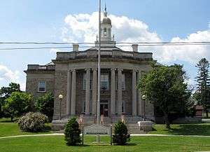
Ticonderoga town offices | |
 Location in Essex County and the state of New York | |
| Coordinates: 43°51′30″N 73°27′15″W / 43.85833°N 73.45417°WCoordinates: 43°51′30″N 73°27′15″W / 43.85833°N 73.45417°W | |
| Country | United States |
| State | New York |
| County | Essex |
| Government | |
| • Type | Town Council |
| • Town Supervisor | Joseph Giordano (Write In Candidate) |
| • Town Council |
Members' List
|
| Area | |
| • Total | 88.5 sq mi (229.1 km2) |
| • Land | 81.4 sq mi (210.9 km2) |
| • Water | 7.0 sq mi (18.2 km2) |
| Elevation | 663 ft (202 m) |
| Population (2010) | |
| • Total | 5,042 |
| • Density | 62/sq mi (23.9/km2) |
| Time zone | Eastern (EST) (UTC-5) |
| • Summer (DST) | EDT (UTC-4) |
| ZIP codes | 12858, 12883 |
| Area code(s) | 518 |
| FIPS code | 36-73891 |
| GNIS feature ID | 0979547 |
| Website |
townofticonderoga |
Ticonderoga is a town in Essex County, New York, United States. The population was 5,042 at the 2010 census.[1] The name comes from the Mohawk tekontaró:ken, meaning "it is at the junction of two waterways".[2]
The town of Ticonderoga is in the southeastern corner of the county and is south of Plattsburgh.
History
The crossing between Lakes George and Champlain had been used by natives for thousands of years. In the 17th century, French explorers such as Samuel de Champlain explored the area.
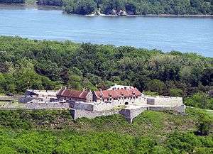
The town was located on the direct route, utilizing rivers and two long lakes, between New York City to the south and the French settlement of Montreal to the north. The town was the setting for historic battles and maneuvers during both the French and Indian War and the American Revolutionary War. Fort Ticonderoga, constructed by the French, who called it Fort Carillon, in the 1750s, marked the location of an important portage between the two lakes.
The town of Ticonderoga was formed in 1804 from part of the town of Crown Point. By the end of the 18th century, the town was noted for wood products such as paper and lead pencils. The position of the now former Ticonderoga village at the north end of Lake George made it an important port.
Historic Fort Ticonderoga is in this town, east of the former village of Ticonderoga.
Geography
According to the United States Census Bureau, the town has a total area of 88.5 square miles (229.1 km2), of which 81.4 square miles (210.9 km2) is land and 7.0 square miles (18.2 km2), or 7.93%, is water.[1]
The town encompasses both the north end of Lake George and a portion of Lake Champlain near its southern end. The short, but rapidly flowing, La Chute River connects the two lakes. The east town line is the border of Vermont, and the south town line is the county line of Warren County and Washington County.
New York State Route 9N is a north-south highway. Another north-south highway, New York State Route 22, is partly conjoined with NY-9N in the town. New York State Route 74, an east-west highway, intersects NY-9N/NY-22 near Ticonderoga village.
Demographics
| Historical population | |||
|---|---|---|---|
| Census | Pop. | %± | |
| 1820 | 1,493 | — | |
| 1830 | 1,996 | 33.7% | |
| 1840 | 2,169 | 8.7% | |
| 1850 | 2,669 | 23.1% | |
| 1860 | 2,271 | −14.9% | |
| 1870 | 2,590 | 14.0% | |
| 1880 | 3,304 | 27.6% | |
| 1890 | 3,980 | 20.5% | |
| 1900 | 5,048 | 26.8% | |
| 1910 | 4,940 | −2.1% | |
| 1920 | 5,267 | 6.6% | |
| 1930 | 5,105 | −3.1% | |
| 1940 | 4,859 | −4.8% | |
| 1950 | 5,204 | 7.1% | |
| 1960 | 5,617 | 7.9% | |
| 1970 | 5,839 | 4.0% | |
| 1980 | 5,436 | −6.9% | |
| 1990 | 5,149 | −5.3% | |
| 2000 | 5,167 | 0.3% | |
| 2010 | 5,042 | −2.4% | |
| Est. 2014 | 5,002 | [3] | −0.8% |
As of the census of 2010, there were 5,042 people, 2,028 households, and 1,352 families residing in the town. The population density was 63.2 people per square mile (24.4/km²). There were 2,581 housing units at an average density of 31.6 per square mile (12.2/km²). The racial makeup of the town was 98.08% White, 0.46% African American, 0.31% Native American, 0.27% Asian, 0.02% Pacific Islander, and 0.85% from two or more races. Hispanic or Latino of any race were 0.41% of the population.[5]
There were 2,028 households out of which 31.4% had children under the age of 18 living with them, 50.0% were married couples living together, 11.3% had a female householder with no husband present, and 33.3% were non-families. 28.4% of all households were made up of individuals and 13.0% had someone living alone who was 65 years of age or older. The average household size was 2.49 and the average family size was 3.04.[5]
In the town the population was spread out with 26.7% under the age of 18, 6.5% from 18 to 24, 26.2% from 25 to 44, 24.4% from 45 to 64, and 16.2% who were 65 years of age or older. The median age was 38 years. For every 100 females there were 93.5 males. For every 100 females age 18 and over, there were 90.4 males.[5]
The median income for a household in the town was $34,160, and the median income for a family was $41,992. Males had a median income of $35,896 versus $21,441 for females. The per capita income for the town was $16,418. About 10.5% of families and 15.5% of the population were below the poverty line, including 21.4% of those under age 18 and 9.7% of those age 65 or over.[5]
Arts and culture
Tourism
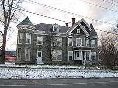
The H. G. Burleigh House was built in 1894 and is a Queen Anne-style building with Colonial Revival features. It was originally owned by U.S Congressman Henry G. Burleigh, and has been on the National Register of Historic Places since 1988.[6][7]
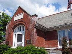
In addition to the Burleigh House, the Amherst Avenue Historic District, Black Watch Library, Central School, Clark House, Community Building, Clayton H. Delano House, Crandall Marine Railway, Ferris House, Fort Ticonderoga, Frazier Bridge, Gilligan and Stevens Block, Hancock House, Lake George Avenue Historic District, Liberty Monument, Silas B. Moore Gristmill, NYS Armory, Pad Factory, Ticonderoga High School, Ticonderoga National Bank, Ticonderoga Pulp and Paper Company Office, and United States Post Office are listed on the National Register of Historic Places.[8]
Infrastructure
Rail transportation
Amtrak, the national passenger rail system, provides service to Ticonderoga, operating its Adirondack daily in both directions between Montreal and New York City.
Notable people
- Henry G. Burleigh, congressman from New York[9]
- Charles Quigg, Wisconsin physician and legislator, born in Ticonderoga[10]
- John A. Rice, Wisconsin physician and legislator, born in Ticonderoga[11]
Communities and locations in Ticonderoga
- Baldwin – A hamlet located on the western shore of Lake George on County Road 5, southwest of Ticonderoga hamlet.
- Black Point – The eastern shore of Lake George.
- Chilson – Sparsely populated location near the town's geographic center on NY-74.
- Eagle Lake – A lake at the north town line, bordered by NY-74 on the south side.
- Fort Ticonderoga – The historic fort that figured in two colonial wars.
- Fort Ticonderoga Station – A location southeast of Ticonderoga hamlet on the east side of Mount Defiance. Former passenger railroad station; the modern Amtrak station is located in Ticonderoga hamlet.
- Mount Defiance – An elevation (853 feet (260 m) above sea level) on the south side of Ticonderoga hamlet that overlooks Fort Ticonderoga.
- Putnam Pond – A small lake in the western part of Ticonderoga.
- Street Road – Location in the north end of town, situated around NY-9N.
- Ticonderoga – A hamlet and census-designated place located in the southeast part of the town, situated on the La Chute River.
- Ticonderoga Muni (4B6) – A general aviation airport north of Ticonderoga hamlet.
- Wright- small area in the southeast corner of Ticonderoga, bordering Putnam Station, NY in Washington County
References
- 1 2 "Geographic Identifiers: 2010 Demographic Profile Data (G001): Ticonderoga town, Essex County, New York". U.S. Census Bureau, American Factfinder. Retrieved March 7, 2016.
- ↑ Afable, Patricia O. and Madison S. Beeler (1996). "Place Names", in "Languages", ed. Ives Goddard. Vol. 17 of Handbook of North American Indians, ed. William C. Sturtevant. Washington, D.C.: Smithsonian Institution, p. 193
- ↑ "Annual Estimates of the Resident Population for Incorporated Places: April 1, 2010 to July 1, 2014". Retrieved June 4, 2015.
- ↑ "Census of Population and Housing". Census.gov. Retrieved June 4, 2015.
- 1 2 3 4 "American FactFinder". United States Census Bureau. Retrieved 2008-01-31.
- ↑ Christine May (January 18, 2014). "National Register of Historic Places Registration: H. G. Burleigh House". New York State Office of Parks, Recreation and Historic Preservation. Retrieved 2010-06-26.
- ↑ "TICONDEROGA YESTERDAY - PlaceSense". PlaceSense. Retrieved January 18, 2014.
- ↑ National Park Service (2010-07-09). "National Register Information System". National Register of Historic Places. National Park Service.
- ↑ "BURLEIGH, Henry Gordon, (1832 - 1900)". Biographical Directory of the United States Congress. Retrieved January 16, 2014.
- ↑ 'Wisconsin Blue Book 1893,' Biographical Sketch of Charles Quigg, pg. 648
- ↑ The Legislative Manual of the State of Wisconsin 1875
External links
| Wikimedia Commons has media related to Ticonderoga, New York. |
| Wikivoyage has a travel guide for Ticonderoga. |
- Town of Ticonderoga official website
- Ticonderoga Area Chamber of Commerce
- Ticonderoga historical summary
- Ticonderoga area information
- Local Guide to Ticonderoga NY
-
 Chisholm, Hugh, ed. (1911). "Ticonderoga". Encyclopædia Britannica (11th ed.). Cambridge University Press.
Municipalities and communities of Essex County, New York, United States | ||
|---|---|---|
| Towns | 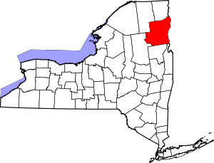 | |
| Villages | ||
| CDPs | ||
| Other hamlets | ||
| Footnotes | ‡This populated place also has portions in an adjacent county or counties | |