Port Henry, New York
| Port Henry, New York | |
|---|---|
| Village | |
|
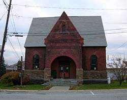
Sherman Free Library | |
 Location in Essex County and the state of New York | |
| Coordinates: 44°2′43″N 73°27′40″W / 44.04528°N 73.46111°WCoordinates: 44°2′43″N 73°27′40″W / 44.04528°N 73.46111°W | |
| Country | United States |
| State | New York |
| County | Essex |
| Town | Moriah |
| Area | |
| • Total | 1.5 sq mi (3.8 km2) |
| • Land | 1.2 sq mi (3.0 km2) |
| • Water | 0.3 sq mi (0.8 km2) |
| Elevation | 243 ft (74 m) |
| Population (2010) | |
| • Total | 1,194 |
| • Density | 1,015/sq mi (391.8/km2) |
| Time zone | Eastern (EST) (UTC-5) |
| • Summer (DST) | EDT (UTC-4) |
| ZIP code | 12974 |
| Area code(s) | 518 |
| FIPS code | 36-59333 |
| GNIS feature ID | 0960967 |
| Website |
www |
Port Henry is a village in Essex County, New York, United States. The population was 1,194 at the 2010 census.[1]
Port Henry lies on the east side of the town of Moriah and is approximately one hour's drive (52 miles or 84 km)[2] south of Plattsburgh. It is 44 miles (71 km) by road south-southwest of Burlington, Vermont, 115 miles (185 km) north of Albany, New York, and 113 miles (182 km) south of Montreal, Quebec.[2]
History

Port Henry is in a tract of land set aside by the British Crown for veterans of the Seven Years' War (also known as the French and Indian War). Although a mill was built in 1765, no other European-American settlers arrived until 1785, after the American Revolutionary War. The Iroquoian-speaking Mohawk and Oswegatchie, members of the Seven Nations of Canada, were still living in the town until after 1800.[3] Most of the Iroquois from the territory of New York had been resettled in Canada, forced out of New York and the United States due to their alliance with the British during the war.
In the early years, timber harvesting was a major industry and 20 mills were located in the area. The first dock was built on Lake Champlain by 1820 for shipping lumber to other ports.[4]
Early settlers discovered iron ore a few miles inland. Its extraction and processing became an important industry in the township for about one hundred and fifty years. A blast furnace constructed in 1822 in Port Henry was one of the first in the United States, and Republic Steel established major operations in the county. The village residents used Lake Champlain and the Hudson River to transport its ore and products to major markets such as Albany and New York City. Later a railroad connected the village to markets.[4]
The village of Port Henry was incorporated in 1869. Voters approved that the village will be dissolved, effective March 31, 2017.[5]
By the end of the 19th century, residents harvested smelt from the lake for the restaurant trade, by ice fishing. This became important winter recreation and continues to attract tourists.
The Delaware & Hudson Railroad Depot, Moriah Town Office Building, Mount Moriah Presbyterian Church, Port Henry Fire Department Building, Sherman Free Library, and Van Ornam & Murdock Block are listed on the National Register of Historic Places.[6]
Geography


Port Henry is located in eastern Essex County at 44°2′43″N 73°27′40″W / 44.04528°N 73.46111°W (44.045238, -73.461011),[7] in the eastern part of the town of Moriah. The village is on the west shore of Lake Champlain at the north end of Bulwagga Bay and is in the Adirondack Park.
According to the United States Census Bureau, the village has a total area of 1.5 square miles (3.8 km2), of which 1.2 square miles (3.0 km2) is land and 0.3 square miles (0.8 km2), or 20.29%, is water.[1]
Port Henry is located on conjoined New York State Route 9N and New York State Route 22 (North/South Main Street) at the junction of County Road 4 (Broad Street).
Demographics
| Historical population | |||
|---|---|---|---|
| Census | Pop. | %± | |
| 1880 | 2,494 | — | |
| 1890 | 2,436 | −2.3% | |
| 1900 | 1,751 | −28.1% | |
| 1910 | 2,266 | 29.4% | |
| 1920 | 2,183 | −3.7% | |
| 1930 | 2,040 | −6.6% | |
| 1940 | 1,935 | −5.1% | |
| 1950 | 1,831 | −5.4% | |
| 1960 | 1,767 | −3.5% | |
| 1970 | 1,532 | −13.3% | |
| 1980 | 1,450 | −5.4% | |
| 1990 | 1,263 | −12.9% | |
| 2000 | 1,152 | −8.8% | |
| 2010 | 1,194 | 3.6% | |
| Est. 2015 | 1,148 | [8] | −3.9% |
As of the census[10] of 2000, there were 1,152 people, 491 households, and 295 families residing in the village. The population density was 958.7 people per square mile (370.7/km²). There were 596 housing units at an average density of 496.0 per square mile (191.8/km²). The racial makeup of the village was 97.66% White, 0.52% African American, 0.09% Native American, 0.61% Asian, 0.61% from other races, and 0.52% from two or more races. Hispanic or Latino of any race were 1.30% of the population.
There were 491 households out of which 27.9% had children under the age of 18 living with them, 42.0% were married couples living together, 12.8% had a female householder with no husband present, and 39.9% were non-families. 33.6% of all households were made up of individuals and 16.7% had someone living alone who was 65 years of age or older. The average household size was 2.29 and the average family size was 2.90.
In the village the population was spread out with 24.7% under the age of 18, 7.8% from 18 to 24, 25.4% from 25 to 44, 22.1% from 45 to 64, and 19.9% who were 65 years of age or older. The median age was 40 years. For every 100 females there were 94.6 males. For every 100 females age 18 and over, there were 86.9 males.
The median income for a household in the village was $29,306, and the median income for a family was $40,556. Males had a median income of $34,821 versus $20,703 for females. The per capita income for the village was $17,455. About 12.2% of families and 19.2% of the population were below the poverty line, including 27.6% of those under age 18 and 10.7% of those age 65 or over.
Transportation
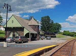
Amtrak, the national passenger rail system, provides service to Port Henry, operating its Adirondack daily in both directions between Montreal, Canada and New York City.
A few miles south of Port Henry, the Champlain Bridge was built in 1929, connecting Crown Point to Vermont. In 2009, the bridge was demolished. A temporary ferry service, operated by the Lake Champlain Transportation Company and funded by the states of New York and Vermont, provided access to Vermont until a new bridge (Route 185) at the same location opened in November 2011.[11][12]
Notable people
- Tom Tyler (1903–1954), actor
- Ernest Guerin Mayor
- Gary Cooke Mayor
- Ruth MacDonough Mayor
- Art Rich Mayor
Cultural references
The village of Port Henry is mentioned in the song "Two Coins" by the Vermont-based band Dispatch.
References
- 1 2 "Geographic Identifiers: 2010 Demographic Profile Data (G001): Port Henry village, New York". U.S. Census Bureau, American Factfinder. Retrieved February 22, 2016.
- 1 2 Google Maps
- ↑ Darren Bonaparte, "The Seven Nations of Canada: The Other Iroquois Confederacy", The Wampum Chronicles, accessed 10 January 2009
- 1 2 "Moriah, NY", Essex County Historical Society, Adirondack History Center Museum, accessed 31 January 2011
- ↑ <http://www.pressrepublican.com/news/port-henry-residents-give-dissolution-the-go-ahead/article_305cd9a0-6420-11e6-ac78-6732b1d37f64.html The Press Republican, Port Henry residents give dissolution the go-ahead by Denise Raymo and Suzanne Moore, August 16, 2016, Retrieved Oct. 4, 2016.
- ↑ National Park Service (2010-07-09). "National Register Information System". National Register of Historic Places. National Park Service.
- ↑ "US Gazetteer files: 2010, 2000, and 1990". United States Census Bureau. 2011-02-12. Retrieved 2011-04-23.
- ↑ "Annual Estimates of the Resident Population for Incorporated Places: April 1, 2010 to July 1, 2015". Retrieved July 2, 2016.
- ↑ "Census of Population and Housing". Census.gov. Retrieved June 4, 2015.
- ↑ "American FactFinder". United States Census Bureau. Retrieved 2008-01-31.
- ↑ Temporary Lake Champlain ferry service begins, Boston.com, February 1, 2010.
- ↑ Essex County, NY Board of Supervisors Minutes, February 1, 2010.
External links
- Port Henry-Town of Moriah official website
- "Moriah, NY", Essex County Historical Society, Adirondack History Center Museum
- Port Henry Marina
- Van Slooten Harbour Marina
Municipalities and communities of Essex County, New York, United States | ||
|---|---|---|
| Towns | 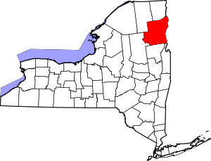 | |
| Villages | ||
| CDPs | ||
| Other hamlets | ||
| Footnotes | ‡This populated place also has portions in an adjacent county or counties | |