Three Holes Cross
Coordinates: 50°31′44″N 4°48′25″W / 50.529°N 4.807°W
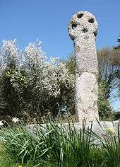
Three Holes Cross.
Three Holes Cross is a crossroads on the A39 trunk road approximately 2 miles east of Wadebridge, Cornwall, United Kingdom at grid reference SX 012 736. The name is derived from the Cornish cross sited there. There is a settlement of a few houses nearby. The nearest house, a little way away from the cross was formerly the toll house in olden days to allow passage to Wadebridge.
An Iron Age fort known locally as Kelly Rounds (but mapped by Ordnance Survey as Castle Killibury) is situated 300 metres west of Three Holes Cross.
External links
![]() Media related to Three Holes Cross at Wikimedia Commons
Media related to Three Holes Cross at Wikimedia Commons
Cornwall Portal | |
| Unitary authorities | |
| Major settlements |
|
| Rivers | |
| Topics | |
This article is issued from Wikipedia - version of the 1/23/2016. The text is available under the Creative Commons Attribution/Share Alike but additional terms may apply for the media files.