Thorndon, Suffolk
| Thorndon | |
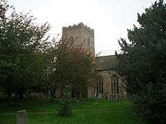 All Saints Church, Thorndon |
|
 Thorndon |
|
| Population | 648 (2011)[1] |
|---|---|
| OS grid reference | TM126719 |
| – London | 92 mi (148 km) |
| District | Mid Suffolk |
| Shire county | Suffolk |
| Region | East |
| Country | England |
| Sovereign state | United Kingdom |
| Post town | Eye |
| Postcode district | IP23 |
| Dialling code | 01379 |
| Police | Suffolk |
| Fire | Suffolk |
| Ambulance | East of England |
| EU Parliament | East of England |
Coordinates: 52°17′10″N 1°07′41″E / 52.286°N 1.128°E
Thorndon is a village and civil parish in the Mid Suffolk district of Suffolk in eastern England.[2] The village is located around three miles south of Eye, close to the A140.It is located 92 miles North East of London. In 2011 the population was 648, recorded by the 2011 Census.[1] Village facilities include a Post Office, All Saints' Church and a local primary school.
Suffolk, The county Thordon is in, was voted the best place to live in 2009 due to people having the best quality of life, as people have good health, cheap house prices and low crime rate.[3] Thorndon Community council, run by chairman Mick Supple, take part in regular meetings and put on events for the community to enjoy. They also publish the 'Village Life' Magazine.[4]
History
The origin of the name Thorndon, traces back to Old English meaning 'Thorn Hill', coming from 'þorn' meaning a hawthorn-tree and 'dūn' meaning A hill.[5] Throndon was first mentioned in the Doomsday book dating back to 1086, describing it as Hill where thorn-trees grow and having a population of just 46 people. It was also recorded to have two manors, the main one being owned by the Wulfeva family and the other owned by the Turchetal family. In 1337, the manor was owned by Robert de Ufford and All Saints' Church was added.[6] [7] In the 1870s, John Marius Wilson Described as:
- A parish, with a village, in Hartismere district, Suffolk; 3 miles S of Eye r. station.The church is ancient but good, and has been restored. There are a reformatory, a national school, and town lands.[8]
Thorndon is home to one church, All Saints' Church. Listed as a Grade II building since 1955, It displays exceptional 15th Century carvings on the front of grinning Lions and Angels crafted locally in the nearby town of Occold.[9]
The Boundaries of Thorndon, Suffolk have not changed, with the parish being located to the south of Eye.[10] In the early 19th century, the only education people of the parish received was at Sunday school, as there were no schools in the parish until 1833, when an infant school was built. However, in 1856, it was brought and turned into a reformatory by Sir Edward Kerrison.[11] This is now owned by the Kerrinson Trust and has been turned into a conference centre for the parish to use.[12]
Demographics
The earliest records of Thorndon's population date back to 1811, with the total population being 580. In 1851, it reached its highest total population of 725, but then slowly decreased to the last recorded figure of 468 from the 2011 census; this could be due to a number of reasons, such as industrialisation and people moving to urban areas. However, in 1931 it dipped to its lowest population.[13] Thorndon is home to 272 houses; in recent times there has been a drop in population meaning less cramped living conditions compared to the 139 houses when population was at 675 in 1870.[12]
90% of Thorndon is made up of White British people, with the other 10% being Black or Asian; this is mainly due to the rural location of the town.[14] Thorndon has an ageing population, with many being over 60 years old, shown by the census conducted in 2011[15]


The Census Report of 2011 also shows that 90% of the population are of very good health or good health. This could be due to the affluent area of Thorndon is.[16]
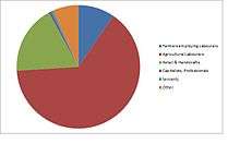
According to the 2011 census,the predominant occupation in Thorndon is agriculture and construction, this is due to the rural nature of the town. Other popular occupations include manufacturing and retail trade, which have become increasingly popular in recent years.[17]
Places of Interest
- All Saints' Church A big church situated in the parish of Hartismere. Built in the 13th Century, by Robert De Ufford, Earl of Suffolk, with later improvements including an oak screen, built by a local craftsman. This has allowed community activities to take place including the 'T-Plus' project to happen.[18] Other community activities include the 'Cafe Church' which takes place on the last Sunday of every month.This brings the community of all ages together, giving them the opportunity to have something to eat whilst being entertained by the Parable Players. The Lynch Gate as you enter the church, contains a village war memorial, for World War II.
- The Black Horse A popular country pub in the heart of Thorndon. Originally it was the Black Horse Inn, that was built in the 1600s but was later converted into a pub. in 1998 there was a fire which destroyed most of the roof but was managed to be restored and reopened.[19] The village does not have its own post office therefor a mobile post office is parked up in the pub car park from 9.30am to 11am Monday to Friday.[12]
- Thorndon CEVC primary school The school is a Church of England Voluntary controlled school situated in the heart of the countryside. It caters for children from age 4-11 and welcomes any religion, however being a Church of England school it does associate itself with the church community and participates in church assemblies and celebrating other Christian events. The school currently has 64 students with up to 12 children per year group. Thorndon does not contain any secondary schools, the nearest one for residents to go to is Hartismere School & 6th Form College in Eye.[20]
- Thorndon Community Shop The Community shop is open 7 days a week serving the community. It was originally owned by the same owners as 'The Black Horse' however it has since then been handed over to the community to run. Local volunteers allow the shop to happen by their hard work, it is also helped along by donations from the parish and local councils. They stock local produce like bread from the Tudor bake house in Eye and milk from the Halesworth Dairy. The shop also included a photocopier.[21]
- Thorndon Leek Club The club was founded in 1995, it celebrates the village community spirit by socials, competitions and local events. The biggest event for them is the September show, held at the black horse. The club have regular meetings there to discuss village events and how to support the Church, School, Pub and other places in the Village.[22]
References
- 1 2 "Thorndon (Parish): Key Figures for 2011 census: Key Statistics". Neighbourhood Statistics. Office for National Statistics. Retrieved 4 February 2014.
- ↑ OS Explorer map 211: Bury St.Edmunds and Stowmarket Scale: 1:25 000. Publisher:Ordnance Survey – Southampton A2 edition. Publishing Date:2008. ISBN 978 0319240519|accessdate= April 2014
- ↑ http://www.independent.co.uk/news/uk/home-news/sleepy-suffolk-is-simply-the-best-place-to-live-1644891.html
- ↑ http://thorndon.onesuffolk.net/home/thorndon-community-council/|accessdate= April 2014
- ↑ http://kepn.nottingham.ac.uk/map/place/Suffolk/Thorndon|accessdate= April 2014
- ↑ http://thorndon.onesuffolk.net/history-of-thorndon-suffolk/|accessdate= April 2014
- ↑ Doomsday Book. 1086.
- ↑ Wilson, John Marius (1870–72). Imperial Gazetteer of England and Wales (1st ed.). Edinburgh: A. Fullarton & Co. Retrieved 4 February 2014.
- ↑ http://thorndon.onesuffolk.net/all-saints-church/|accessdate=24 March 2014
- ↑ http://www.visionofbritain.org.uk/unit/10270911/boundary|accessdate= April 2014
- ↑ http://thorndon.onesuffolk.net/history-of-thorndon-suffolk/kerrison-reformatory-school/|accessdate= April 2014
- 1 2 3 http://thorndon.onesuffolk.net/home/about-thorndon/|accessdate= April 2014
- ↑ http://www.visionofbritain.org.uk/unit/10270911/cube/TOT_POP|accessdate= April 2014
- ↑ http://www.neighbourhood.statistics.gov.uk/dissemination/LeadTableView.do?a=7&b=11129570&c=Thorndon&d=16&e=61&g=6466561&i=1001x1003x1032x1004&m=0&r=1&s=1398632518668&enc=1&dsFamilyId=2575|accessdate= April 2014
- ↑ http://www.neighbourhood.statistics.gov.uk/dissemination/LeadTableView.do?a=7&b=11129570&c=Thorndon&d=16&e=61&g=6466561&i=1001x1003x1032x1004&m=0&r=1&s=1398632518652&enc=1&dsFamilyId=2545|accessdate= April 2014
- ↑ http://www.neighbourhood.statistics.gov.uk/dissemination/LeadTableView.do?a=7&b=11129570&c=Thorndon&d=16&e=61&g=6466561&i=1001x1003x1032x1004&m=0&r=1&s=1398675042815&enc=1&dsFamilyId=2503
- ↑ http://www.neighbourhood.statistics.gov.uk/dissemination/LeadTableView.do?a=7&b=11129570&c=Thorndon&d=16&e=62&g=6466561&i=1001x1003x1032x1004&m=0&r=1&s=1398634621418&enc=1&dsFamilyId=2538|accessdate= April 2014
- ↑ http://www.genuki.org.uk/big/eng/SFK/ThorndonAllSaints/|accessdate= April 2014
- ↑ http://www.theblackhorsethorndon.co.uk/about.html|accessdate= April 2014
- ↑ http://thorndon.onesuffolk.net/home/pre-school-and-schools/|accessdate= April 2014
- ↑ http://thorndon.onesuffolk.net/home/thorndon-community-shop/|accessdate= April 2014
- ↑ http://thorndon.onesuffolk.net/home/leisure-and-social-activities/|accessdate= April 2014
External links
![]() Media related to Thorndon, Suffolk at Wikimedia Commons
Media related to Thorndon, Suffolk at Wikimedia Commons
| Boroughs or districts | |
|---|---|
| Major settlements | |
| Topics | |