Texas State Highway 59
| ||||
|---|---|---|---|---|
 | ||||
| Route information | ||||
| Maintained by TxDOT | ||||
| Length: | 56.181 mi[1] (90.415 km) | |||
| Existed: | before 1933 – present | |||
| Major junctions | ||||
| South end: |
| |||
| North end: |
| |||
| Highway system | ||||
| ||||

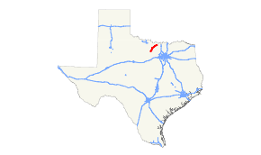
State Highway 59 or SH 59 is a state highway that runs from Jacksboro to St. Jo in Texas.
History
The original SH 59 was designated by 1926 between Palacios and Midfield. By 1928, this route was transferred to SH 58. By 1933, SH 59 was designated again between Bowie and Montague, with a proposed extension north to Nocona. By 1939, it was rerouted, so instead of going north from Montague to Nocona, it ran east from Montague to Saint Jo. In 1945, it was extended further south to near Jacksboro, with the final extension into Jacksboro in 1968 over previous SH 24, which had been rerouted farther south.
Junction list
| County | Location | mi[2] | km | Destinations | Notes |
|---|---|---|---|---|---|
| Jack | Jacksboro | Southern terminus | |||
| | 9.3 | 15.0 | |||
| | 20.4 | 32.8 | |||
| Clay | Newport | 21.4 | 34.4 | ||
| Montague | Bowie | 32.8 | 52.8 | ||
| 33.9 | 54.6 | ||||
| 34.1 | 54.9 | ||||
| | 37.0 | 59.5 | |||
| Montague | 44.3 | 71.3 | |||
| 44.6 | 71.8 | ||||
| St. Jo | 56.2 | 90.4 | Northern terminus | ||
| 1.000 mi = 1.609 km; 1.000 km = 0.621 mi | |||||
References
- ↑ Transportation Planning and Programming Division (n.d.). "State Highway No. 59". Highway Designation Files. Texas Department of Transportation. Retrieved December 13, 2015.
- ↑ Google (December 13, 2015). "Overview of SH 59" (Map). Google Maps. Google. Retrieved December 13, 2015.
This article is issued from Wikipedia - version of the 10/29/2016. The text is available under the Creative Commons Attribution/Share Alike but additional terms may apply for the media files.