Tebay
| Tebay | |
 Railway cottages |
|
 Tebay |
|
| Population | 776 (2011) |
|---|---|
| OS grid reference | NY618045 |
| Civil parish | Tebay |
| District | Eden |
| Shire county | Cumbria |
| Region | North West |
| Country | England |
| Sovereign state | United Kingdom |
| Post town | PENRITH |
| Postcode district | CA10 |
| Dialling code | 01539 |
| Police | Cumbria |
| Fire | Cumbria |
| Ambulance | North West |
| EU Parliament | North West England |
| UK Parliament | Penrith and The Border |
Coordinates: 54°26′02″N 2°35′24″W / 54.434°N 2.590°W
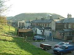
Tebay is a village and civil parish in Cumbria, England, within the historic borders of Westmorland. It lies in the upper Lune Valley, at the head of the Lune Gorge. Tebay had a population of 776 at the 2011 Census.[1]
Old Tebay lies to the north of Tebay at grid reference NY618052. Historically a sheep farming area, the arrival of the railway led to increased prosperity.
History
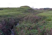
To the north, occupying a strategic position by the River Lune, now close to the M6 motorway, are the earthwork remains of a motte and bailey castle known as Castle Howe.
During the Roman occupation a Roman road followed the course of the River Lune linking a fort at Low Borrow Bridge near Tebay with one at Over Burrow south of Kirkby Lonsdale.
Tebay was the home of the prophetess Mary Baynes, known as the 'Witch of Tebay', who died in 1811.[2]
Transport
Railways
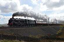
Tebay railway station was on the Lancaster and Carlisle Railway, which was built to link those two cities between 1844 and 1846, and which was absorbed by the London and North Western Railway in 1879. Tebay became an important junction for, in 1861, the Stainmore Railway, from Tebay-Kirkby Stephen-Barnard Castle and later becoming part of the North Eastern Railway, brought traffic from the east; it was closed in 1962. The A685 runs over much of its trackbed east from Tebay towards Kirkby Stephen. The Ingleton Branch Line of the Lancaster and Carlisle Railway connecting via the Midland Railway to Settle and Leeds, enters the main line at the south end of the Lune Gorge; it was built in the 1850s, and was last used for passengers in the winter 1962-63 as a relief to the main line.

The railway companies provided much employment for local people and this brought about the construction of housing to accommodate the increased population.
The village has had two railway accidents happen nearby. On 15 February 2004, four people were run over by a maintenance vehicle in the Tebay rail accident. Three years later, the Grayrigg rail crash happened on 23 February 2007 between Oxenholme and Tebay on the West Coast Main Line.
Roads
Junction 38 of the M6 lies just west of the village, south of the notoriously exposed Shap Summit. Like its predecessor, the main railway line, it uses the upper reaches of the River Lune to pass through the fells. Tebay Services is one of the very few motorway service stations to be run independently, and has often won praise for its food.
The village
Central to the village is the Railway Club. This provides a concrete link to the past raison d'etre of the village. The two pubs in the village also provide a place where the inhabitants can come together. In times past a great proportion of populace was involved with the railway and the local Junction Hotel is now flats where once were dance halls.
See also
 |
Penrith | | ||
| Greenholme | |
Kirkby Stephen | ||
| ||||
| | ||||
| Sedbergh |
References
- ↑ "Parish population 2011". Retrieved 22 June 2015.
- ↑ "Tebay, Cumbria". The Cumbria Directory. Retrieved 24 August 2014.
External links
| Wikimedia Commons has media related to Tebay. |
Cumbria Portal | |
| Boroughs or districts | |
| Major settlements |
|
| Topics | |