Tates Bluff, Arkansas
| Tates Bluff, Arkansas | |
|---|---|
| Unincorporated community | |
 Tates Bluff, Arkansas  Tates Bluff, Arkansas | |
| Coordinates: 33°47′56″N 92°54′04″W / 33.79889°N 92.90111°WCoordinates: 33°47′56″N 92°54′04″W / 33.79889°N 92.90111°W | |
| Country | United States |
| State | Arkansas |
| County | Ouachita |
| Elevation | 200 ft (60 m) |
| Time zone | Central (CST) (UTC-6) |
| • Summer (DST) | CDT (UTC-5) |
| Area code(s) | 870 |
| GNIS feature ID | 57203[1] |
Tates Bluff is an unincorporated community in Ouachita County, Arkansas, United States. Tates Bluff is located near the northern border of Ouachita County 15.2 miles (24.5 km) north-northwest of Camden.[2] The Tate's Bluff Fortification, which is listed on the National Register of Historic Places, is located near Tates Bluff.[3]
References
- ↑ "Tates Bluff". Geographic Names Information System. United States Geological Survey.
- ↑ Ouachita County, Arkansas General Highway Map (PDF) (Map). Arkansas State Highway and Transportation Department. 2008. Retrieved December 1, 2012.
- ↑ National Park Service (2010-07-09). "National Register Information System". National Register of Historic Places. National Park Service.
Municipalities and communities of Ouachita County, Arkansas, United States | ||
|---|---|---|
| Cities | 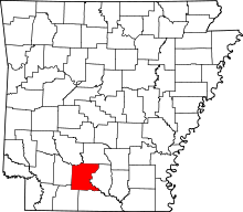 | |
| Town | ||
| CDP | ||
| Unincorporated communities | ||
This article is issued from Wikipedia - version of the 7/29/2016. The text is available under the Creative Commons Attribution/Share Alike but additional terms may apply for the media files.