Chidester, Arkansas
| Chidester, Arkansas | |
|---|---|
| City | |
|
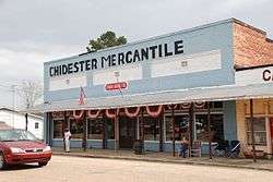
Chidester Mercantile on Main St | |
 Location in Ouachita County and the state of Arkansas | |
| Coordinates: 33°42′5″N 93°1′24″W / 33.70139°N 93.02333°WCoordinates: 33°42′5″N 93°1′24″W / 33.70139°N 93.02333°W | |
| Country | United States |
| State | Arkansas |
| County | Ouachita |
| Area | |
| • Total | 5.3 sq mi (13.8 km2) |
| • Land | 5.3 sq mi (13.8 km2) |
| • Water | 0 sq mi (0 km2) |
| Elevation | 236 ft (72 m) |
| Population (2000) | |
| • Total | 335 |
| • Density | 63.2/sq mi (24.3/km2) |
| Time zone | Central (CST) (UTC-6) |
| • Summer (DST) | CDT (UTC-5) |
| ZIP code | 71726 |
| Area code(s) | 870 |
| FIPS code | 05-13750 |
| GNIS feature ID | 0057546 |
Chidester is a city in Ouachita County, Arkansas, United States. The population was 335 at the 2000 census. It is part of the Camden Micropolitan Statistical Area.
Geography
Chidester is located at 33°42′5″N 93°1′24″W / 33.70139°N 93.02333°W (33.701331, -93.023349).[1]
According to the United States Census Bureau, the city has a total area of 5.3 square miles (14 km2), all of it land.
Demographics
| Historical population | |||
|---|---|---|---|
| Census | Pop. | %± | |
| 1910 | 211 | — | |
| 1920 | 280 | 32.7% | |
| 1930 | 399 | 42.5% | |
| 1940 | 508 | 27.3% | |
| 1950 | 425 | −16.3% | |
| 1960 | 348 | −18.1% | |
| 1970 | 232 | −33.3% | |
| 1980 | 342 | 47.4% | |
| 1990 | 489 | 43.0% | |
| 2000 | 335 | −31.5% | |
| 2010 | 287 | −14.3% | |
| Est. 2015 | 271 | [2] | −5.6% |
2014 Estimate[4] | |||
As of the census[5] of 2000, there were 335 people, 142 households, and 94 families residing in the city. The population density was 62.9 people per square mile (24.3/km²). There were 182 housing units at an average density of 34.2/sq mi (13.2/km²). The racial makeup of the city was 37.01% White, 62.39% Black or African American, 0.30% Native American, and 0.30% from two or more races.
There were 142 households out of which 17.6% had children under the age of 18 living with them, 43.7% were married couples living together, 16.2% had a female householder with no husband present, and 33.8% were non-families. 30.3% of all households were made up of individuals and 16.2% had someone living alone who was 65 years of age or older. The average household size was 2.36 and the average family size was 2.89.
In the city the population was spread out with 20.9% under the age of 18, 8.1% from 18 to 24, 22.7% from 25 to 44, 25.4% from 45 to 64, and 23.0% who were 65 years of age or older. The median age was 44 years. For every 100 females there were 87.2 males. For every 100 females age 18 and over, there were 82.8 males.
The median income for a household in the city was $21,397, and the median income for a family was $29,000. Males had a median income of $27,656 versus $20,250 for females. The per capita income for the city was $13,425. About 21.8% of families and 27.3% of the population were below the poverty line, including 42.4% of those under age 18 and 20.8% of those age 65 or over.
Education
Public education for elementary and secondary school students is available from Camden Fairview School District, which leads to graduation from Camden Fairview High School.
Climate
The climate in this area is characterized by hot, humid summers and generally mild to cool winters. According to the Köppen Climate Classification system, Chidester has a humid subtropical climate, abbreviated "Cfa" on climate maps.[6]
References
- ↑ "US Gazetteer files: 2010, 2000, and 1990". United States Census Bureau. 2011-02-12. Retrieved 2011-04-23.
- ↑ "Annual Estimates of the Resident Population for Incorporated Places: April 1, 2010 to July 1, 2015". Retrieved July 2, 2016.
- ↑ "Census of Population and Housing". Census.gov. Archived from the original on May 11, 2015. Retrieved June 4, 2015.
- ↑ "Annual Estimates of the Resident Population for Incorporated Places: April 1, 2010 to July 1, 2014". Retrieved June 4, 2015.
- ↑ "American FactFinder". United States Census Bureau. Archived from the original on 2013-09-11. Retrieved 2008-01-31.
- ↑ Climate Summary for Chidester, Arkansas
Municipalities and communities of Ouachita County, Arkansas, United States | ||
|---|---|---|
| Cities | 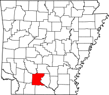 | |
| Town | ||
| CDP | ||
| Unincorporated communities | ||