Tanohata, Iwate
| Tanohata 田野畑村 | |||
|---|---|---|---|
| Village | |||
|
Tanohata Village Hall | |||
| |||
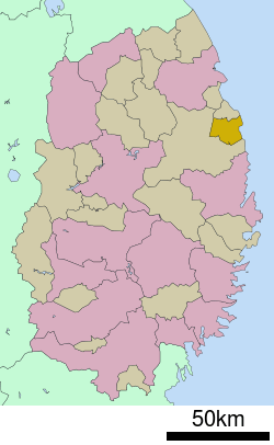 Location of Tanohata in Iwate Prefecture | |||
 Tanohata
| |||
| Coordinates: 39°55′49″N 141°53′20″E / 39.93028°N 141.88889°ECoordinates: 39°55′49″N 141°53′20″E / 39.93028°N 141.88889°E | |||
| Country | Japan | ||
| Region | Tōhoku | ||
| Prefecture | Iwate | ||
| District | Shimohei | ||
| Area | |||
| • Total | 156.19 km2 (60.31 sq mi) | ||
| Population (February 2014) | |||
| • Total | 3,582 | ||
| • Density | 22.9/km2 (59/sq mi) | ||
| Time zone | Japan Standard Time (UTC+9) | ||
| City symbols | |||
| • Tree | Paulownia tomentosa | ||
| • Flower | Rhododendron subg. Hymenanthes | ||
| • Bird | Copper pheasant | ||
| Phone number | 0194-34-2111 | ||
| Address | 143-1 Tanohata, Tanohata-mura, Shimohei-gun, Iwate-ken 028-8407 | ||
| Website | Official website | ||


Tanohata (田野畑村 Tanohata-mura) is a village located in Shimohei District, Iwate, Japan. As of February 2014, the town had an estimated population of 3,582 and a population density of 22.9 persons per km2. The total area was 156.19 km2.
Geography
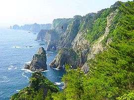
Tanohata is a coastal mountainous community situated on the Sanriku Coast along the Pacific Ocean. Parts of the village are within the borders of the Sanriku Fukkō National Park.[1]
Neighboring municipalities
- Iwate Prefecture
History
The area of present-day Tanohata was part of ancient Mutsu Province, dominated by the Nambu clan during the Edo period, who ruled Hachinohe Domain under the Tokugawa shogunate. The village of Tanohata was created within Kitahei District on April 1, 1889. Kitahei, Nakahei and Higashihei Districts were all merged into Minamihei District on March 29, 1896. The area is prone to tsunami, with damage recorded as early as the 869 Sanriku earthquake. The 1611 Sanriku earthquake also caused major damage and the 1896 Sanriku earthquake destroyed most of the village, as did the 1933 Sanriku earthquake.
In 1953, the national and prefectural governments targeted Fudai for consolidation with its southern neighbor, Tanohata following the Law for the Consolidation of Cities, Towns and Villages ("the great Shōwa mergers").[2] Merger talks continued intermittently between 1955 and 1960. The Tanohata delegation was not in favor of the merger, but because of the pressure from the prefecture to implement the government directive, they felt they were not at liberty to directly reject the proposal. At a party in May 1960 to celebrate the end of the long merger negotiations, the mayor of Tanohata drunkenly insulted the delegates from Fudai in a final effort to scuttle the negotiations.[2] The party was abandoned, and no further serious attempts were made to continue with the merger.[2]
The tsunami following the March 11 2011 Tōhoku earthquake and tsunami completely destroyed more than 200 buildings in the village, killing 39 residents and also destroying 512 of the 565 vessels in the local fishing cooperative. [3] The height of the tsunami was estimated at more than 10 meters at Shimanokoshi Station, which was completely washed away. [4] In October 2013, a sign from the village was found washed up on Kahuku Beach, Hawaii.[5]
Economy
The local economy is based on commercial fishing and to a lesser extent on agriculture.
Transportation
Railway
Highway
Local attractions
References
- ↑ "Introducing places of interest: Rikuchukaigan National Park". Ministry of the Environment (Japan). Retrieved 17 May 2011.
- 1 2 3 Bailey, Jackson H. (1991). Ordinary people, extraordinary lives : political and economic change in a Tōhoku village. Honolulu: University of Hawaii Press. p. 272. ISBN 978-0-8248-1299-7.
- ↑ "東日本大震災 図説集". 毎日jp. 毎日新聞社. 2011-04-10. Retrieved 2011-04-17.
- ↑ "三陸鉄道「国の支援なければ、もはや何も…」". YOMIURI ONLINE. 読売新聞社. 2011-04-05. Retrieved 2011-04-05.
- ↑ "Japan's tsunami debris: Five remarkable stories". BBC News. March 9, 2015. Retrieved March 9, 2015.
External links
![]() Media related to Tanohata, Iwate at Wikimedia Commons
Media related to Tanohata, Iwate at Wikimedia Commons
- Official website (Japanese)
| Core city | ||
|---|---|---|
| Cities | ||
| Isawa District | ||
| Iwate District | ||
| Kamihei District | ||
| Kesen District | ||
| Kunohe District | ||
| Ninohe District | ||
| Nishiiwai District | ||
| Shimohei District | ||
| Shiwa District | ||
| Waga District | ||