Ōfunato
| Ōfunato 大船渡市 | |||
|---|---|---|---|
| City | |||
|
Ōfunato City Hall | |||
| |||
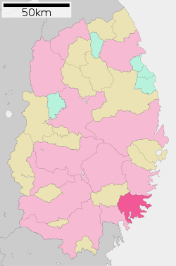 Location of Ōfunato in Iwate Prefecture | |||
 Ōfunato
| |||
| Coordinates: 39°4′4.8″N 141°43′30.8″E / 39.068000°N 141.725222°ECoordinates: 39°4′4.8″N 141°43′30.8″E / 39.068000°N 141.725222°E | |||
| Country | Japan | ||
| Region | Tōhoku | ||
| Prefecture | Iwate | ||
| Area | |||
| • Total | 323.50 km2 (124.90 sq mi) | ||
| Population (September 2015) | |||
| • Total | 38,010 | ||
| • Density | 118/km2 (310/sq mi) | ||
| Time zone | Japan Standard Time (UTC+9) | ||
| City symbols | |||
| - Tree | Pine | ||
| - Flower | Camellia | ||
| - Bird | Black-tailed gull | ||
| Phone number | 0192-27-3111 | ||
| Address | 15, Sakarichō Aza Utsunosawa, Ōfunato-shi, Iwate-ken 022-8501 | ||
| Website | Official website | ||


Ōfunato (大船渡市 Ōfunato-shi) is a city located in Iwate Prefecture, in the Tohoku region of northern Japan. As of September 2015, the city had an estimated population of 38,010 and a population density of 112 persons per km2. The total area was 323.30 square kilometres (124.83 sq mi).
History
The area of present-day Ōfunato was part of ancient Mutsu Province, and has been settled since at least the Jomon period. During the Sengoku period, the area was dominated by various samurai clans before coming under the control of the Nambu clan during the Edo period, who ruled Morioka Domain under the Tokugawa shogunate.
The modern village of Ōfunato was created within Kessen District, Iwate on April 1, 1889. The 1896 Sanriku earthquake caused a 25 meter tsunami which killed 27,000 people in Sanriku. Ōfunato was elevated to town status on April 1, 1932. The 1933 Sanriku earthquake had a magnitude of 8.4 and caused a 28 meter tsunami which killed 1522 people.
The neighboring town of Sakari, and the villages of Akasaki, Takkon, Massaki, Ikawa and Hikoroichi merged with Ōfunato on April 1, 1952, forming the city of Ōfunato. The city became internationally famous when it was hit by a tsunami caused by the Valdivia earthquake in Chile May 22, 1960. On November 15, 2001, the town of Sanriku (from Kesen District) was merged into Ōfunato.
2011 Tōhoku earthquake and tsunami

Ōfunato hit the headlines yet again when it was heavily damaged in the 2011 Tōhoku earthquake and tsunami.[1] The wave was estimated to have reached 23.6 meters in height.[2] Funneled in by the narrow bay, the tsunami continued inland for 3 kilometres.[3] The town's theatre was one of very few buildings left standing (and remarkably, was undamaged) and gave shelter to about 250 survivors.[4][5] Provisional counts listed 3,498 houses out of 15,138 houses in the town destroyed by the tsunami and 305 lives were confirmed lost.[6][7] At least six of the town's 58 designated evacuation sites were inundated by the tsunami.[8] Ofunato was featured in the British documentary "Japan's Tsunami Caught on Camera" which was broadcast on Channel 4 in the United Kingdom.
Geography
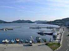
Ōfunato is located in southeastern Iwate Prefecture, facing the Pacific Ocean. Outside its bay, the warm and cold ocean currents meet, which allow a fishing industry to flourish. The city has been trying to establish itself as a major shipping port and receives regular visits by international freight ships. Kaminari-iwa on the city's Goishi coastline has been designated one of the 100 Soundscapes of Japan by the Ministry of the Environment.[9] Much of the city is within the borders of the Sanriku Fukkō National Park.
Neighboring municipalities
- Iwate Prefecture
Climate
Ōfunato has a humid subtropical climate (Köppen climate classification Cfa) bordering on a humid continental climate (Köppen climate classification Dfa) with warm summers and cold winters. Precipitation is significant throughout the year, but is heaviest from April to October.
| Climate data for Ōfunato, Iwate | |||||||||||||
|---|---|---|---|---|---|---|---|---|---|---|---|---|---|
| Month | Jan | Feb | Mar | Apr | May | Jun | Jul | Aug | Sep | Oct | Nov | Dec | Year |
| Average high °C (°F) | 4.1 (39.4) |
4.3 (39.7) |
7.5 (45.5) |
13.5 (56.3) |
18.5 (65.3) |
21.3 (70.3) |
24.5 (76.1) |
26.9 (80.4) |
23.0 (73.4) |
18.2 (64.8) |
12.7 (54.9) |
7.1 (44.8) |
15.13 (59.24) |
| Daily mean °C (°F) | 0.4 (32.7) |
0.5 (32.9) |
3.2 (37.8) |
8.8 (47.8) |
13.6 (56.5) |
17.3 (63.1) |
20.8 (69.4) |
23.0 (73.4) |
19.0 (66.2) |
13.4 (56.1) |
8.1 (46.6) |
3.2 (37.8) |
10.94 (51.69) |
| Average low °C (°F) | −3.2 (26.2) |
−3.3 (26.1) |
−1.0 (30.2) |
3.9 (39) |
8.8 (47.8) |
13.6 (56.5) |
17.7 (63.9) |
19.8 (67.6) |
15.3 (59.5) |
8.7 (47.7) |
3.4 (38.1) |
−0.7 (30.7) |
6.92 (44.44) |
| Average precipitation mm (inches) | 45.7 (1.799) |
61.4 (2.417) |
86.6 (3.409) |
141.6 (5.575) |
149.7 (5.894) |
154.0 (6.063) |
165.3 (6.508) |
197.6 (7.78) |
194.5 (7.657) |
138.7 (5.461) |
99.6 (3.921) |
44.3 (1.744) |
1,479 (58.228) |
| Average snowfall cm (inches) | 12 (4.7) |
19 (7.5) |
10 (3.9) |
0 (0) |
0 (0) |
0 (0) |
0 (0) |
0 (0) |
0 (0) |
0 (0) |
1 (0.4) |
7 (2.8) |
49 (19.3) |
| Average relative humidity (%) | 62 | 63 | 63 | 67 | 72 | 80 | 84 | 82 | 80 | 74 | 68 | 64 | 71.6 |
| Mean monthly sunshine hours | 153.6 | 146.1 | 176.1 | 177.2 | 208.4 | 163.7 | 151.4 | 165.5 | 124.9 | 154.1 | 138.9 | 140.1 | 1,900 |
| Source: NOAA (1961-1990) [10] | |||||||||||||
Economy
The local economy is largely based on commercial fishing.
Education
- Kitasato University – Sanriku campus
- Ōfunato has 12 elementary schools, eight middle schools and three high schools.
Transportation
Railway
- Sanriku Railway Company – Minami-Rias Line
- Sakari - Rikuzen-Akasaki - Ryōri - Koishihama - Horei - Sanriku - Yoshihama
Highway
Port
- Port of Ōfunato
Local attractions
International relations
-
 Spain – Palos de la Frontera, Huelva, Spain [11] – sister city since 12 August 1992
Noted people from Ōfunato
- Yoshinobu Fujiwara – politician
- Nanae Sasaki – marathon runner
- Tochinohana Hitoshi – sumo wrestler
References
- ↑ Ofunato devastated by tsunami BBC report, 12 March 2011
- ↑ "23.6-meter-high tsunami triggered by March 11 quake: survey" Kyodo News, 23 March 2011
- ↑ A thousand bodies a day will be recovered every day now The Age, 22 March 2011
- ↑ Synopsis of a Channel 4 TV news bulletin on 15 March 2011
- ↑ Tritten, Travis, J., and T. D. Flack, "U.S. rescue teams find devastation in northern city of Ofunato", Stars and Stripes, 15 March 2011, retrieved 16 March 2011.
- ↑ NOAA tsunami data table
- ↑ Gilhooly, Rob, "Survivors strive to start picking up the pieces", Japan Times, 27 March 2011, p. 7.
- ↑ Kyodo News, "Tsunami hit more than 100 designated evacuation sites", Japan Times, 14 April 2011, p. 1.
- ↑ "100 Soundscapes of Japan". Ministry of the Environment. Retrieved 8 December 2015.
- ↑ "Ofunato Climate Normals 1961-1990". National Oceanic and Atmospheric Administration. Retrieved 29 December 2012.
- ↑ "International Exchange". List of Affiliation Partners within Prefectures. Council of Local Authorities for International Relations (CLAIR). Retrieved 21 November 2015.
External links
![]() Media related to Ōfunato at Wikimedia Commons
Media related to Ōfunato at Wikimedia Commons
- Official website (Japanese)
- Ofunato in ruins Channel 4 news report, 15 March 2011
- Searching for the lost in Ofunato BBC report by Damian Grammaticas, 23 March 2011
| Core city | ||
|---|---|---|
| Cities | ||
| Isawa District | ||
| Iwate District | ||
| Kamihei District | ||
| Kesen District | ||
| Kunohe District | ||
| Ninohe District | ||
| Nishiiwai District | ||
| Shimohei District | ||
| Shiwa District | ||
| Waga District | ||