Tamenglong
| Tamenglong | |
|---|---|
| Town | |
 | |
 Tamenglong  Tamenglong Location in Manipur, India | |
| Coordinates: 24°59′26.39″N 93°30′3.26″E / 24.9906639°N 93.5009056°ECoordinates: 24°59′26.39″N 93°30′3.26″E / 24.9906639°N 93.5009056°E | |
| Country |
|
| State | Manipur |
| District | Tamenglong |
| Elevation[1] | 1,061 m (3,481 ft) |
| Population (2011)[2] | |
| • Total | 19,363 |
| Languages | |
| • Spoken | Rongmei, Liangmai, Zeme |
| Time zone | IST (UTC+5:30) |
| PIN | 795141 |
| Telephone code | 03877 |
| Vehicle registration | MN |
| Literacy | 70.40% |
| Website | Official website |
Tamenglong is an Indian town, district headquarter of Tamenglong district, in the state of Manipur. People of Zeliangrong community lives here. Rongmei language is predominantly spoken in and around the town.
Geography
Tamenglong, located in the western part of the state, lies on the hilltop that descends Barak River. It is 160 km east of Imphal, Manipur's capital city.
Tamenglong District
Tamenglong District consists of virgin forests, exotic orchids, rare and endangered plants, and wildlife. The forests can be grouped as tropical evergreen forest, subtropical forest and bamboo brakes. The dense tropical evergreen forests are located along the sides of rivers flowing in the district. Tamenglong is called the land of the hornbill. Great pied hornbill (Buceros bicornis homrai), Indian pied hornbill (Anthracoceros malabaricus malabaricus) species are found here. A number of exquisite orchids are also found here. They are epiphytic, lithophytic and terrestrial in nature.
Places of interest
Tamenglong district of Manipur has a topography of irregular undulation with turbulent waters, waterfall, dark caves, lakes, dense tropical forest.
- Along the river Barak there are seven waterfalls in series at close range.
- The Tharon cave (Chalem-Ky) is located at about 27 km from the district HQ. The map of the entire cave is engraved and painted on a stone at the main entrance. Archeological excavation of the cave shows affinities with Hobinian culture of North Vietnam.
- The legendary Zeilad lake at Makoi (Atengba) is associated with a number of pythons, fishes and water birds. There are six other lakes nearby in the likes of Guiphop Zei, Nrou Zei, Nap-sam Zei etc.
- The Buning (Npiulong) meadow is located on the western side of the picturesque Tamei town. A number of well-groomed uneven small mounds, numerous glittering brooks on the stretch. Come June the meadow is colored with enchanting ground orchids and various Wild Lilies. Cry of Hoolock Gibbon, howling of foxes, melodious chirping of birds altogether form Buning a big family of the wildlife evoking wonder and admiration to many who have witnessed the meadow.
Main tribes (inhabitants)
- Rongmei Naga
- Zeme Naga
- Liangmai Naga
- Npui Naga
Climate
Köppen-Geiger climate classification system classifies its climate as humid subtropical (Cwa).[3] Tamenglong is a highland which makes the temperatures cooler. The warmer months are extremely rainy. July receives most rain while December is the driest.
| Climate data for Tamenglong | |||||||||||||
|---|---|---|---|---|---|---|---|---|---|---|---|---|---|
| Month | Jan | Feb | Mar | Apr | May | Jun | Jul | Aug | Sep | Oct | Nov | Dec | Year |
| Average high °C (°F) | 18.6 (65.5) |
20 (68) |
23.8 (74.8) |
25.8 (78.4) |
25.9 (78.6) |
25.5 (77.9) |
25.4 (77.7) |
25.5 (77.9) |
25.1 (77.2) |
24.2 (75.6) |
23.6 (74.5) |
19.2 (66.6) |
23.55 (74.39) |
| Daily mean °C (°F) | 12.2 (54) |
13.8 (56.8) |
17.5 (63.5) |
20.1 (68.2) |
21.2 (70.2) |
21.9 (71.4) |
22.1 (71.8) |
22.2 (72) |
21.6 (70.9) |
19.9 (67.8) |
16.2 (61.2) |
13.1 (55.6) |
18.48 (65.28) |
| Average low °C (°F) | 5.9 (42.6) |
7.7 (45.9) |
11.2 (52.2) |
14.4 (57.9) |
16.5 (61.7) |
18.4 (65.1) |
18.9 (66) |
18.9 (66) |
18.1 (64.6) |
15.7 (60.3) |
10.9 (51.6) |
7.1 (44.8) |
13.64 (56.56) |
| Average precipitation mm (inches) | 34 (1.34) |
46 (1.81) |
168 (6.61) |
223 (8.78) |
324 (12.76) |
688 (27.09) |
728 (28.66) |
535 (21.06) |
323 (12.72) |
217 (8.54) |
42 (1.65) |
8 (0.31) |
3,336 (131.33) |
| Source: Climate-Data.org (altitude: 1266m)[3] | |||||||||||||
Gallery
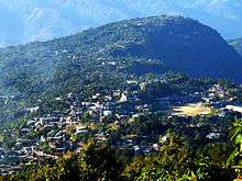
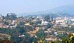 View of town as seen from Gaidai foothill
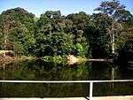 The school goers hideout fame Farmland Lake.
 Raengon Bamduan
 Prayer Mountain
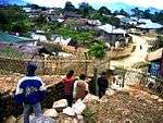 Nriangluang
 Rah Nouh Bung (Ghost Breasts) at Barak
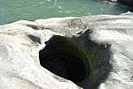 Asha Naaploih (Asha Rice Pot) at Barak
 The famous Kacha Khou (Mountain) at Magulong
References
- ↑ Tamenglong on fallingrain.com
- ↑ Tamenglong (2011 Census of India)
- 1 2 "Tamenglong - Climate graph, Temperature graph, Climate table". Climate-Data.org. Retrieved 2016-01-04.
External links
| Wikimedia Commons has media related to Tamenglong. |