Tallahatchie River


The Tallahatchie River is a river in Mississippi which flows 230 miles (370 km)[1]from Tippah County, through Tallahatchie County, to Leflore County, where it joins the Yalobusha River to form the Yazoo River.[2][3] The river is navigable for about 100 miles.[4]
Tallahatchie is a Choctaw name meaning "rock of waters."[5] The sources of the Tallahatchie River have outcrops of iron sandstone.[6]
As part of the Flood Control Act of 1936, the federal government built an earth-filled flood control dam on the Tallahatchie near the town of Sardis, Mississippi, creating Sardis Lake.
Tributaries
- Coldwater River (Mississippi)
- Old Yocona River
- Yocona River Canal[7]
- Little Tallahatchie River
- Old Little Tallahatchie River
- Panola Quitman Floodway[8]
- McIvor Drainage Canal
- Tippah River
- Cassidy Bayou
- Black Bayou
- Ascalmore Creek
- Tillatoba Creek
In popular culture
The river is mentioned in "Tallahatchie River Blues," recorded by Mattie Delaney in 1930. This blues song laments the devastation caused in the local African-American community by a flood on the normally shallow river. The river is 50 ft (15 m) deep with very sharp rocks.
The river has historical significance due to the 1955 murder of Emmett Till, an African-American youth visiting from Chicago, who was brutally murdered by white men in Money for allegedly being impolite to a white woman. He was beaten, shot, and sunk in the river with a cotton gin fan tied around his neck by barbed wire. This event is mentioned in the song, "Freedom Highway" by The Staple Singers, in the lines, "Found dead people in the forests, Tallahatchie River and lakes... whole world is wondering, what's wrong with the United States?"
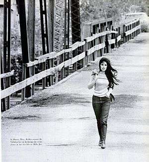
The eponymous wooden bridge over the river was popularized in Bobbie Gentry's 1967 hit song "Ode to Billie Joe," which has the refrain, "Billie Joe McAllister jumped off the Tallahatchie bridge." A film was titled Ode to Billy Joe. The wooden bridge collapsed in 1972 after being set alight by vandals.[9] It crossed the Tallahatchie River at Money, about ten miles north of Greenwood, Mississippi, and has since been replaced.
See also
References
- ↑ Hopkins, Daniel J., editor (1997). Merriam-Webster's Geographical Dictionary. (Third Edition). Springfield, MA: Merriam-Webster, Inc. Publishers. p.1155.ISBN 0-87779-546-0
- ↑ "The National Map". U.S. Geological Survey. Retrieved Feb 9, 2011.
- ↑ "Tallahatchie River". Geographic Names Information System. United States Geological Survey.
- ↑ Hopkins. Merriam-Webster's Geographical Dictionary.
- ↑ Stafford, James Douglas. (16 November 1975). "The Way of the River". The Commercial Appeal. Mid-South Magazine. (Memphis, Tennessee).
- ↑ Rowland, Dunbar. (1925). History of Mississippi: the Heart of the South. 1. Chicago, IL-Jackson, MS: S.J. Clarke Publishing Co. pp. 38-39.
- ↑ Mississippi State Highway Department. General Highway Map Panola County Mississippi. (Map) 1981.
- ↑ Mississippi State Highway Department. General Highway Map Tallahatchie County Mississippi. (Map) 1979.
- 1 2 Tobler, John (1992). NME Rock 'N' Roll Years (1st ed.). London: Reed International Books Ltd. p. 239. CN 5585.
External links
| Wikimedia Commons has media related to Tallahatchie River. |
Coordinates: 33°32′38″N 90°10′4″W / 33.54389°N 90.16778°W