Szentgotthárd
| Szentgotthárd | ||
|---|---|---|
|
City centre with the Rába River | ||
| ||
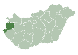
 Szentgotthárd Location of Szentgotthárd | ||
| Coordinates: 46°56′56″N 16°16′45″E / 46.94876°N 16.27907°ECoordinates: 46°56′56″N 16°16′45″E / 46.94876°N 16.27907°E | ||
| Country |
| |
| County | Vas | |
| Area | ||
| • Total | 67.73 km2 (26.15 sq mi) | |
| Population (2004) | ||
| • Total | 9,136 | |
| • Density | 134.88/km2 (349.3/sq mi) | |
| Time zone | CET (UTC+1) | |
| • Summer (DST) | CEST (UTC+2) | |
| Postal code | 9970 | |
| Area code(s) | 94 | |
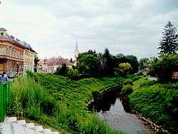

Szentgotthárd (German: St. Gotthard; Slovene: Monošter) is the westernmost town of Hungary. It is situated on the Rába River near the Austrian border, and is home to much of Hungary's small Slovene ethnic minority.
The town took its name from, and grew up round, the Cistercian Szentgotthárd Abbey, founded here in 1183.
In 1664, it was the site of the Battle of Saint Gotthard, where an Austrian army led by Raimondo Montecuccoli defeated the Ottoman Empire so that the Turks had to agree to the Peace of Vasvár, which held until 1683.
The town serves as the cultural centre of the Hungarian Slovenes.
People
External links
This article is issued from Wikipedia - version of the 5/6/2016. The text is available under the Creative Commons Attribution/Share Alike but additional terms may apply for the media files.