Sydenham, New South Wales
For other places called Sydenham, see Sydenham (disambiguation).
| Sydenham Sydney, New South Wales | |||||||||||||
|---|---|---|---|---|---|---|---|---|---|---|---|---|---|
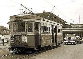 R class tram no 1923 at Sydenham railway station, 20 November 1954. Trams in Sydney services. | |||||||||||||
| Coordinates | 33°55′05″S 151°09′48″E / 33.91808°S 151.16336°ECoordinates: 33°55′05″S 151°09′48″E / 33.91808°S 151.16336°E | ||||||||||||
| Population | 1,021 (2011 census)[1] | ||||||||||||
| Postcode(s) | 2044 | ||||||||||||
| Location | 8 km (5 mi) south of Sydney CBD | ||||||||||||
| LGA(s) | Inner West Council | ||||||||||||
| State electorate(s) | Heffron | ||||||||||||
| Federal Division(s) | Grayndler | ||||||||||||
| |||||||||||||


Sydenham is a suburb in the Inner West[2] of Sydney, in the state of New South Wales, Australia. Sydenham is located 8 kilometres south of Sydney central business district and is part of the local government area of Inner West Council. Sydenham is surrounded by the suburbs of Marrickville, St Peters and Tempe.
History
Sydenham developed after the Illawarra line came through the area to Hurstville in the late 1800s. It was named after Sydenham, a suburb of London, similar for its close proximity to the city and a railway junction. The station was originally known as Marrickville when it opened on 15 October 1884. It was changed to Sydenham on 19 March 1895 when a new line was being built to Bankstown and the first station was to be called Marrickville. The post office opened in April 1899 as Tempe Park and was only renamed Sydenham in 1964.[3]
Transport
Sydenham railway station is a junction for three lines on the Sydney Trains network: the Illawarra, Airport, Inner West & South and Bankstown lines.
Former tram/light rail service
A cross country line connected the Cooks River Line and the Dulwich Hill line via Sydenham, operating along Railway Road and Sydenham Road in Sydenham.
Commercial area
Sydenham has a mixture of residential and industrial developments. A small group of shops is located around the intersection of Unwins Bridge Road and Railway Road, close to Sydenham railway station. Commercial developments are also located along Sydenham and Marrickville Roads heading towards Marrickville. Marrickville Metro Shopping Centre is also very close to Sydenham.
Sydenham Green
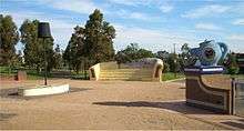
The suburb suffers from aircraft noise because it is directly under the flight path of Sydney Airport. To alleviate resident noise complaints, many of the residential properties between Unwins Bridge Road and the Princes Highway were bought by the government [4] and converted into a recreational park, which was named Sydenham Green after the park in London. Two heritage buildings remain standing along Railway Road: St Marys Church and a sandstone terrace. A series of oversized 'living room' sculptures - lamp, chairs and fireplace pays homage to the residential houses that formerly occupied the site.
References
- ↑ Australian Bureau of Statistics (31 October 2012). "Sydenham (State Suburb)". 2011 Census QuickStats. Retrieved 20 April 2015.
- ↑ Australian Suburb Guide: Sydney Inner West Retrieved 7 August 2013.
- ↑ The Book of Sydney Suburbs, Compiled by Frances Pollon, Angus & Robertson Publishers, 1990, Published in Australia ISBN 0-207-14495-8, page 251
- ↑ http://www.greenleft.org.au/1995/208/10958
External links
- Chrys Meader - Marrickville Council (2008). "Sydenham". Dictionary of Sydney. Retrieved 29 September 2015. [CC-By-SA]