Enmore, New South Wales
| Enmore Sydney, New South Wales | |||||||||||||
|---|---|---|---|---|---|---|---|---|---|---|---|---|---|
 Victorian commercial building, Enmore and Edgeware Roads | |||||||||||||
| Population | 3,572 (2011 census)[1] | ||||||||||||
| • Density | 8,405/km2 (21,770/sq mi) | ||||||||||||
| Postcode(s) | 2042 | ||||||||||||
| Area | 0.4 km2 (0.2 sq mi) | ||||||||||||
| Location | 5 km (3 mi) from CBD | ||||||||||||
| LGA(s) | Inner West Council | ||||||||||||
| State electorate(s) | Newtown | ||||||||||||
| Federal Division(s) | Grayndler | ||||||||||||
| |||||||||||||
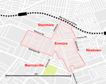

Enmore is a suburb in the Inner West[2] of Sydney, in the state of New South Wales, Australia. Enmore is located 5 kilometres south-west of the Sydney central business district and is part of the local government area of Inner West Council.[3]
History
Enmore was named after Enmore House, built in 1835 by Captain Sylvester Browne, a master mariner with the British East India Company. Browne named his house after the Guyana estate of a business associate, the head of James Cavan & Co, which in turn took its name from Enmore in Somerset, England. Browne's son wrote several Australian classics, including Robbery Under Arms, under the name of Rolf Boldrewood.
In 1836, there was a report of snowfall in the suburb. Weather observer T.A Browne stated, "the years 1836, 1837 and 1838 were years of drought, and in one of these years [1836] a remarkable thing happened. There was a fall of snow; we made snowballs at Enmore and enjoyed the usual schoolboy amusements therewith".[4]
Enmore House was the home of the Josephson family from 1842 to 1883, when it was demolished. After Josephson's death, his son Joshua Frey Josephson lived there until 1883. Joshua Frey Josephson had four sons and nine daughters from three marriages. One son, Joshua Percy Josephson, was Mayor of Marrickville in 1901. Five streets are named after five of the daughters: Clara, Laura, Marian, Pearl and Sarah.[5]
The house at 75 London Street is listed on the Register of the National Estate. It was built circa 1900 and stands out as a notable example of the Federation Queen Anne style, with elaborate Art Nouveau elements.[6]
Commercial area
Enmore is primarily residential, although there is a commercial strip along Enmore Road, which turns off the more famous King Street, Newtown. The now disused, former Enmore Post Office (built 1895) on the corner of Enmore and Stanmore Roads, is listed on the Register of the National Estate as an example of Federation Queen Anne architecture.[7] It was designed by the government architect, Walter Liberty Vernon.
Schools
The suburb is home to the Design Campus of the Sydney Institute, on the site of the former Enmore Boys High School.
Culture
- The Enmore Theatre is a renowned live music and comedy venue.
- The Sly Fox, a lesbian/mixed pub. Both Enmore and Newtown have a significant gay and lesbian population.
- Enmore is also a focus for goth subculture in Sydney, with related speciality stores. Enmore Road hosts the annual 'Under the Blue Moon' goth festival.
Population
At the 2011 census, there were 3,572 residents in Enmore. 59.6% of people were born in Australia. The most common other countries of birth were England 4.9%, New Zealand 2.9% and Greece 2.5%. The top responses for religious affiliation were No Religion 42.4%, Catholic 16.5% and Anglican 7.4%. Major industries of employment in Enmore included Tertiary Education 5.6%, Hospitals 4.6%, Cafes, and Restaurants and Takeaway Food Services 3.5%. The most common dwelling type in Enmore was semi-detached, row or terrace houses, townhouses etc. (51.1%). 47.2% of people were renting their home and this was considerably higher than the national rate of 29.6% for renting.[1]
Notable residents
- Rolf Boldrewood, also known as Thomas Alexander Browne, author of Robbery Under Arms.
 Heritage-listed former post office, Enmore Road
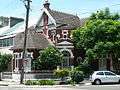 Heritage-listed home, London Street
 Duke Hotel, Enmore Road
References
- 1 2 Australian Bureau of Statistics (31 October 2012). "Enmore (State Suburb)". 2011 Census QuickStats. Retrieved 2 May 2013.
- ↑ Australian Suburb Guide: Sydney Inner West Retrieved 8 August 2013.
- ↑ Gregory's Sydney Street Directory, Gregory's Publishing Company, 2007
- ↑ MacDonnell, Freda. Thomas Nelson (Australia) Limited, 1967. Before King’s Cross
- ↑ Book of Sydney Suburbs, Frances Pollon (Angus and Robertson) 1990, p.99
- ↑ The Heritage of Australia, Macmillan Copmpany, 1981, p.2/44
- ↑ "Enmore Post Office (former) (Place ID 19168)". Australian Heritage Database. Department of the Environment. Retrieved 27 October 2008.
External links
| Wikimedia Commons has media related to Enmore, New South Wales. |
- Chrys Meader (2008). "Enmore". Dictionary of Sydney. Retrieved 27 September 2015. [CC-By-SA]
Coordinates: 33°54′02″S 151°10′04″E / 33.90067°S 151.16768°E