Surprise Canyon Formation
| Surprise Canyon Formation Stratigraphic range: Upper Mississippian, Lower Pennsylvanian, 325–316 Ma | |
|---|---|
|
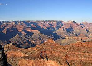
Pattie Butte-(Newton Butte), sitting on 'redbeds' of Supai Group The ridgeline, north sits on Redwall Limestone 'platform'–(2-places, photo-bottom-left, top of red Redwall cliff), and topped by 2nd-platform of Surprise Canyon Formation. Note: 3-prominences: center, "Unnamed"; Newton Butte-(off-photo, right); Pattie Butte, center, bottom-left, (on platform, north terminus). | |
| Type | Geological formation |
| Underlies | Watahomigi Formation, (1st member)-Supai Group 'redbeds' |
| Overlies | Redwall Limestone |
| Thickness | 400 feet (122 m) max (50-400 ft typical) |
| Lithology | |
| Primary | conglomerate, sandstone, limestone |
| Location | |
| Region | Colorado Plateau (southwest areas) |
| Extent | Grand Canyon |
The Late Mississippian-Early Pennsylvanian Surprise Canyon Formation is a conglomerate, sandstone, limestone[2][3] and dark purple siltstone type formation, occurring as 'channel fill'.[4] The Surprise Canyon Formation was deposited upon a mostly horizontal, much eroded Redwall Limestone surface, the Redwall originally deposited as marine-(oceanic) limestone, (400 to 700 ft thick); when the Surprise Canyon Formation was being deposited, the Redwall Limestone surface existed under karst topography conditions, in a "warm, and humid"[5] (paleo)-environment. The karst topography created "sinks, caves, and underground channels", and created "deep ravines and stream valleys developed as caverns collapsed".[6] Some valleys probably filled with " 'clayey red-orange soil' similar to that known in the Tropics today."[7] Below the Redwall surface, solution-cavern deposits of the Surprise Canyon, have a Redwall Limestone geologic layer, now expressed above them.
The Surprise Canyon Formation is found extensively in regions below Grand Canyon Village, Arizona, South Rim, regions northwest, north, and northeast. It is discontinuous, but is found in geologic sequences below the South Rim, and its various landforms, and also especially at the Inner Gorge in specific landforms that have cliffs, and upper surface platforms of the Redwall Limestone. Example landforms near Grand Canyon Village, are Pattie Butte-(Newton Butte), Tower of Set, (due west of Isis Temple), and Brahma Temple's southern Redwall Limestone points, Johnson and Sturdevant Points, due east of Isis Temple.
Fossils of plant material, marine shells, where some fossils may have been 'derived fossils' from the Redwall Limestone, are found in the formation; also fossil logs, showing the erosion, or valley and canyon topographies and the erosional forces of the time period.
Besides the easily recognized locations of the Surprise Canyon Formation on the Redwall Limestone platforms, it is found in more vertical sequences where the lowest Supai Group member, the Watahomigi Formation, major sub-unit 1 of 4, transitions, and sits upon the Surprise Canyon, upon the Redwall Limestone. As stated, the Surprise Canyon in the Grand Canyon Village region is discontinuous, but occurs in all sub-sections, further explaining a many-channeled paleo-surface of the eroding Redwall Limestone. The supplementing, and later hypothesis is that marine conditions, to the west of the proto-North American continent, had created an estuarine region, with accumulations of the continental erosion; with apparent uniform thicknesses of the Surprise Canyon, as opposed to highly variable thickness, near sea-level conditions, and probably lack of high terrains on the eroding Redwall surface, and all factors leading to the thin, discontinuous accumulations, but thin lenses, and regionally extensive in the estuary (sea level) region.
The Redwall Limestone member itself is massive, and is very continuous, and is found as a base geologic unit for much of Grand Canyon; it also forms the walls of Marble Canyon in the northeast canyon, where the Colorado River makes its entrance, about 30-mi,[8] north-northeast of the Grand Canyon Village region, South Rim.
Surprise Canyon and Temple Butte Formations
In the central Grand Canyon, the Surprise Canyon and Temple Butte formations have equivalent thicknesses, averaging 75-150 ft. The major difference between the two is that the Devonian Temple Butte was deposited in the western Grand Canyon, and regions in Nevada, on the passive margin of the North American proto continent; the continental shelf was subsiding, and the Temple Butte reached a thickness of about 400 feet (122 m) in west Grand Canyon at the Grand Wash Cliffs, and even greater thicknesses 2,000 feet (610 m)) in the Frenchman Mountain region of Nevada.
Both the Temple Butte and Surprise Canyon Formations were deposited on erosional unconformities, on karst terrains of the Muav and Redwall limestones.
The following is a chart of the Surprise Canyon Formation, Redwall Limestone, Temple Butte Formation, and other related geologic units across the Colorado Plateau:[9]
| Grand Canyon and central-northeast Arizona | East and southeast Utah | Uncompahgre Uplift | NE Utah NW Colorado (proto)-Uintah Basin region |
|---|---|---|---|
| Ancestral Rocky Mountains (eroded to sea level, 165 Ma)[10] |
|||
| Supai Group ~340-(330) to 285 Ma (million years ago) |
Hermosa Group | Ancestral Rocky Mtns | Hermosa Group |
| 1-(316 Ma) Watahomigi Formation Unit 1 of 4 of Supai Group, Upper Pennsylvanian-Lower Permian |
(Hermosa) | Ancestral Rocky Mtns | Hermosa members? |
| 320 Ma-Surprise Canyon Formation-(325-316 Ma?) (Grand Canyon only) |
xxxxx | "Ancestral Rocky Mtns" | xxxxx |
| 5 Million yr? erosion unconformity |
"Ancestral Rocky Mtns" | ||
| 365-330 Ma Mississippian Redwall Limestone |
Leadville Limestone | Ancestral Rocky Mtns | Leadville Limestone |
| 410-365 Ma-(?)-Devonian- Temple Butte Formation- 400 ft thick in west Grand Canyon, (greater thickness in Nevada) (Verde Valley, AZ, ~100-mi southeast of Grand Canyon, named Martin Formation) |
Elbert Formation? | Ancestral Rocky Mtns | |
| 50 Million yrs? -erosion unconformity (Ordovician-65 Million, Silurian, 25 Million, no deposition) |
Ancestral Rocky Mtns | ||
| 505 Ma 3 Muav Limestone 515 Ma 2 Bright Angel Shale 525 Ma (~520 Ma)-1-Tapeats Sandstone-(or ~544 Ma) |
3?-Lynch Dolomite 2-Bright Angel Shale 1?-Sawatch Sandstone[11] |
Ancestral Rocky Mtns | |
 Dramatic Redwall Limestone cliffs, on ridgeline (cliffline) south, and part of the Tower of Set, East Granite Gorge (Inner Gorge, Grand Canyon)
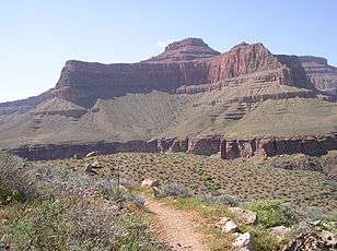 The Tower of Set on Inner Gorge-(east Granite Gorge).(View, from across Granite Gorge (south side, short Tapeats Sandstone cliffs visible at top of Gorge), from the Tonto Trail.)
See also
References
| Wikimedia Commons has media related to Surprise Canyon Formation. |
| Wikimedia Commons has media related to Redwall Limestone platform. |
| Wikimedia Commons has media related to Redwall Limestone cliffs. |
- ↑ Blakey, Ranney, 2008. Ancient Landscapes of the Colorado Plateau, 325 Ma map Redwall Limestone, p. 25, 316 Ma, Watahomigi Formation-(lowest Supai Group), map, p. 32.
- ↑ Geologic Map of the Grand Canyon in the Vicinity of the South Rim Visitor Center, based on: Geologic map of the eastern part of the Grand Canyon National Park, Arizona, P. W. Huntoon and others, (c. 1995, Grand Canyon Association), (from Geologic Highway Map of Arizona, from Reynolds, c. 1988).
- ↑ South Rim (geologic) Visitor Center Map, Stratigraphy Chart.
- ↑ South Rim (geologic) Visitor Center Map, Stratigraphy Chart.
- ↑ Chronic, 1983. Roadside Geology of Arizona, c. 1983, Grand Canyon National Park, pp. 279-287, p. 283.
- ↑ Chronic, 1983, p. 283.
- ↑ Chronic, 1983, p. 283.
- ↑ Arizona Road & Recreation Atlas, Benchmark Maps, 2nd Edition, c. 1998, pp. 62-63.
- ↑ Blakey, Ranney, 2008. Ancient Landscapes of the Colorado Plateau, Graphic: Columnar cross-sections of Paleozoic rocks showing the stratigraphic nomenclature and correlations used in this book, pg. XVIII.
- ↑ Blakey, Ranney, 2008. Ancient Landscapes of the Colorado Plateau, 165 Ma map: (upper)-Carmel Formation, with Sundance Sea, p. 76, and p. 78.
- ↑ Blakey, Ranney, 2008. Ancient Landscapes of the Colorado Plateau, Graphic: Columnar cross-sections of Paleozoic rocks showing the stratigraphic nomenclature and correlations used in this book, pg. XVIII.
- Arizona Road & Recreation Atlas, Benchmark Maps, 2nd Edition, c. 1998, 112 pages, pp. 28–29, 62-63.
- Blakey, and Ranney, 2008. Ancient Landscapes of the Colorado Plateau, Ron Blakey, Wayne Ranney, c 2008, Grand Canyon Association (publisher), 176 pages, with Appendix, Glossary, Index. Contains approximately 75 shaded topographic maps, for geology, etc., with 54 (23 pairs, (46)) for Colorado Plateau specifically; others are global, or North American. (softcover, ISBN 978-1-934656-03-7)
- Chronic, 1983. Roadside Geology of Arizona, c. 1983, 23rd printing, Mountain Press Publishing Co. 322 pages. Grand Canyon National Park, pp. 279–287, (p. 283). (softcover, ISBN 978-0-87842-147-3)