Newton Butte
| Newton Butte | |
|---|---|
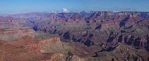 View west, downriver, South Rim at left – Newton Butte on horizon, left, opposite Granite Gorge, and two Points of Zoroaster Temple (prominence), in the 2 shadows, Bradley Point, Demaray Point (Newton Butte, ~8 mi from Moran Point) | |
| Highest point | |
| Elevation | 5,940 ft (1,811 m) [1] |
| Prominence | 520 ft (158 m) [1] |
| Coordinates | 36°03′37″N 112°03′11″W / 36.060261°N 112.0529447°WCoordinates: 36°03′37″N 112°03′11″W / 36.060261°N 112.0529447°W [2] |
| Geography | |
 Newton Butte
| |
| Location |
Grand Canyon National Park Coconino County, Arizona, U.S. |
| Topo map | USGS Phantom Ranch |
| Geology | |
| Mountain type |
Coconino Sandstone (prominence), Hermit Formation, Supai Group (redbeds), Muav Limestone |
Newton Butte, in the Grand Canyon, Arizona, United States is a prominence below the South Rim, northwest of Grandview Point, and north on a ridgeline from Shoshone Point which is one mile east of Yaki Point, East Rim Drive. Shoshone Point and Yaki are both on access roads from East Rim Drive, with Yaki being the more advantageous to different viewing directions.
Newton Butte is 5,940 feet (1,811 m),[1] and located on a point/ridge, just south of Granite Gorge on the Colorado River. The point location of Newton Butte extends due north from an intermediate point on the South Rim, Shoshone Point,[3] which at the end of the Newton Butte point ridgeline, also forms the west perimeter of the Lonetree Canyon drainage, into Granite Gorge.
Just north of Newton Butte, 3/4 mi on the end of the point, is Pattie Butte, a lower elevation prominence, 5,306 feet (1,617 m).[3]
Two hiking trails are closest to Newton Butte. Across Granite Gorge, views south can be made from the Clear Creek Trail, at lower elevations or as it climbs past Zoroaster Canyon to ridgelines at the west of Clear Creek. The Tonto Trail on the Tonto Platform, south side of Granite Gorge, has the closest hiking points near the bottom elevations of Newton Butte.
Access
Newton Butte can be viewed from the South Rim viewpoints from Yavapai Point, Yaki Point, Shoshone Point, or Grandview Point. Access to East Rim Drive. South Rim, is from the east, on Arizona State Route 64, from US 89. A west access to East Rim Drive is from Williams, Arizona, or Flagstaff, by way of U.S. Route 180 in Arizona.
References
| Wikimedia Commons has media related to |
- 1 2 3 "Newton Butte". ListsOfJohn.com. Retrieved 2014-02-08.
- ↑ "Newton Butte". Geographic Names Information System. United States Geological Survey. Retrieved 2014-02-07.
- 1 2 Arizona Road & Recreation Atlas (2nd ed.). DeLorme. 1998. p. 13.
External links
- "Shoshone Point". Geographic Names Information System. United States Geological Survey. part of Newton Butte
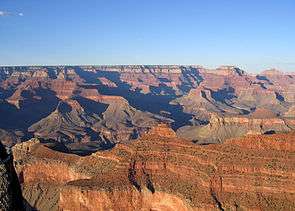 Pattie Butte, (above Supai Group 'redbeds'), on ridgeline from Yaki Point; (Newton Butte prominence off photo, right) View northeast, with Cape Royal (point) on Walhalla Plateau (Kaibab Plateau), and flat-top of Wotans Throne and Vishnu Temple prominence. (from Yavapai Point, west of Yaki Point, South Rim) |
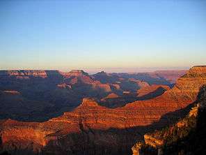 (view east-northeast, from Mather Point-(Yavapai Point)) Pattie Butte, on ridgeline north, from Newton Butte. Pattie Butte sits on an upper platform of Redwall Limestone, overlain by a 2nd-platform of Surprise Canyon Formation. (partly eroded) |