Suntrana, Alaska
| Suntrana, Alaska | |
|---|---|
| Unincorporated community | |
|
Mine plant and Alaska Railroad tracks, mid 1950s. | |
 Suntrana Location within the state of Alaska | |
| Coordinates: 63°51′15″N 148°50′54″W / 63.85417°N 148.84833°WCoordinates: 63°51′15″N 148°50′54″W / 63.85417°N 148.84833°W | |
| Country | United States |
| State | Alaska |
| Borough | Denali |
| Government | |
| • Borough mayor | Clay Walker[1] |
| • State senator | Click Bishop (R) |
| • State rep. | Dave Talerico (R) |
| Elevation | 1,463 ft (446 m) |
| Time zone | Alaska (AKST) (UTC-9) |
| • Summer (DST) | AKDT (UTC-8) |
| GNIS feature ID | 1410410[2] |

Suntrana is an unincorporated community in eastern Denali Borough, Alaska, United States.
It lies along the George Parks Highway south of the city of Anderson, and on the northeastern edge of Denali National Park and Preserve.[3] Its elevation is 1,463 feet (446 m). Located along the right bank of the Healy River, Suntrana lies 3½ miles (5½ km) east of Healy, the county seat of the Denali Borough. The population was 61 at the 1930 census.[2]
The town and mine at Suntrana no longer exist, the site of company housing is now reforested, no remains of the mine, power house or old tipple complex remains.
References
- ↑ 2015 Alaska Municipal Officials Directory. Juneau: Alaska Municipal League. 2015. p. 5.
- 1 2 "Suntrana, Alaska". Geographic Names Information System. United States Geological Survey.
- ↑ Rand McNally. The Road Atlas '08. Chicago: Rand McNally, 2008, p. 6.
Municipalities and communities of Denali Borough, Alaska, United States | ||
|---|---|---|
| City | 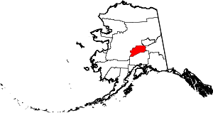 | |
| CDPs | ||
| Unincorporated communities | ||
This article is issued from Wikipedia - version of the 9/11/2016. The text is available under the Creative Commons Attribution/Share Alike but additional terms may apply for the media files.