Cantwell, Alaska
| Cantwell, Alaska Yidateni Na’ | |
|---|---|
| Census-designated place | |
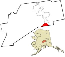 Location in Denali Borough and the state of Alaska. | |
| Coordinates: 63°23′17″N 148°54′1″W / 63.38806°N 148.90028°W | |
| Country | United States |
| State | Alaska |
| Borough | Denali |
| Government | |
| • Borough mayor | Clay Walker[1] |
| • State senator | Click Bishop (R) |
| • State rep. | Dave Talerico (R) |
| Area | |
| • Total | 117.6 sq mi (304.7 km2) |
| • Land | 117.3 sq mi (303.8 km2) |
| • Water | 0.3 sq mi (0.9 km2) |
| Elevation | 2,190 ft (670 m) |
| Population (2010) | |
| • Total | 219 |
| • Density | 2/sq mi (0.7/km2) |
| Time zone | Alaska (AKST) (UTC-9) |
| • Summer (DST) | AKDT (UTC-8) |
| ZIP code | 99729 |
| Area code(s) | 907 |
| FIPS code | 02-10150 |

Cantwell (Yidateni Na’[2] in Ahtna Athabascan) was a railway flag stop at the junction with the Denali Highway. The original town is off the Parks Highway. It is a census-designated place (CDP) in Denali Borough, Alaska, United States. As of the 2010 census, the population of the CDP was 219.[3]
Cantwell is the western terminus of the Denali Highway.
History
Cantwell is named after Lieutenant J. C. Cantwell, military explorer and commander of the revenue steamer Corwin on the Yukon River, 1898-1900. Prior to the settlement, the only inhabitants of the Cantwell area were nomadic Tanana Indians and Athabascan Native Alaskans who hunted and fished. In their language they named Cantwell Yede'teni'na. The town began as a flag stop on the Alaska Railroad. This flagstop supplied the Valdez Creek mining area, which had the name "Denali" for the Valdez Creek community. Many Indians from the village of Tyone came to work at Valdez Creek and later lived out their lives in the Cantwell area. Many Tyones are buried in the old Cantwell graveyard, next to the railroad tracks. Oley Nicklie, a Native Alaskan, sought work with the railroad after fur prices dropped. He and his two brothers then founded part of the settlement.[4] Cantwell is 20 miles away from a giant abandoned igloo shaped hotel, which is not made out of ice.[5]
Cantwell served as a partial filming location for the Lure of the Yukon during the 1920s, and for the 2007 movie Into the Wild.
Geography
Cantwell is located in the southern part of Denali Borough at 63°23′17″N 148°54′1″W / 63.38806°N 148.90028°W (63.388000, -148.900204).[6] It is situated at the north end of Broad Pass, along Cantwell Creek and the Jack River, tributaries of the north-flowing Nenana River. Alaska Route 3, the George Parks Highway, passes through Cantwell: Anchorage is 212 miles (341 km) to the south, and Fairbanks is 150 miles (240 km) to the north.
According to the United States Census Bureau, the Cantwell CDP has a total area of 117.6 square miles (304.7 km2), of which 117.3 square miles (303.8 km2) is land and 0.35 square miles (0.9 km2), or 0.29%, is water.[3]
Climate
Cantwell has a continental subarctic climate (Köppen Dfc)
| Climate data for Cantwell | |||||||||||||
|---|---|---|---|---|---|---|---|---|---|---|---|---|---|
| Month | Jan | Feb | Mar | Apr | May | Jun | Jul | Aug | Sep | Oct | Nov | Dec | Year |
| Record high °F (°C) | 44 (7) |
52 (11) |
58 (14) |
64 (18) |
78 (26) |
87 (31) |
85 (29) |
87 (31) |
71 (22) |
66 (19) |
51 (11) |
45 (7) |
87 (31) |
| Average high °F (°C) | 10.8 (−11.8) |
17.4 (−8.1) |
25.6 (−3.6) |
38.5 (3.6) |
52.9 (11.6) |
64.8 (18.2) |
66 (19) |
60.5 (15.8) |
49.7 (9.8) |
32.2 (0.1) |
17.1 (−8.3) |
14 (−10) |
37.5 (3.1) |
| Average low °F (°C) | −8.8 (−22.7) |
−5.6 (−20.9) |
−1.5 (−18.6) |
14.6 (−9.7) |
28.8 (−1.8) |
38.3 (3.5) |
44.2 (6.8) |
40.3 (4.6) |
30.9 (−0.6) |
14.3 (−9.8) |
−0.6 (−18.1) |
−5.4 (−20.8) |
15.8 (−9) |
| Record low °F (°C) | −49 (−45) |
−47 (−44) |
−45 (−43) |
−32 (−36) |
6 (−14) |
0 (−18) |
28 (−2) |
13 (−11) |
−11 (−24) |
−29 (−34) |
−36 (−38) |
−47 (−44) |
−49 (−45) |
| Average precipitation inches (mm) | 0.96 (24.4) |
0.76 (19.3) |
0.46 (11.7) |
0.43 (10.9) |
0.76 (19.3) |
1.68 (42.7) |
2.66 (67.6) |
3.2 (81) |
2.6 (66) |
1.21 (30.7) |
1.09 (27.7) |
0.93 (23.6) |
16.75 (425.5) |
| Average snowfall inches (cm) | 22.3 (56.6) |
15.8 (40.1) |
12.3 (31.2) |
10.8 (27.4) |
5 (13) |
0.2 (0.5) |
0.2 (0.5) |
0 (0) |
4 (10) |
16.2 (41.1) |
17.5 (44.5) |
19.8 (50.3) |
123.9 (314.7) |
| Average precipitation days | 9 | 7 | 6 | 6 | 8 | 11 | 15 | 16 | 15 | 10 | 8 | 8 | 119 |
| Source: [7] | |||||||||||||
Demographics
As of the census[8] of 2000, there are 222 people, 102 households, and 59 families residing in the CDP. The population density is 1.9 people per square mile (0.7/km²). There are 178 housing units at an average density of 1.5/sq mi (0.6/km²). The racial makeup of the CDP is 65.32% White, 0.45% Black or African American, 22.52% Native American, 1.80% Asian, 0.90% from other races, and 9.01% from two or more races. 1.35% of the population are Hispanic or Latino of any race.
There are 102 households out of which 25.5% have children under the age of 18 living with them, 44.1% are married couples living together, 8.8% have a female householder with no husband present, and 41.2% are non-families. 33.3% of all households are made up of individuals and 2.9% have someone living alone who is 65 years of age or older. The average household size is 2.18 and the average family size is 2.80.
In the CDP the population is spread out with 20.7% under the age of 18, 4.1% from 18 to 24, 37.4% from 25 to 44, 30.2% from 45 to 64, and 7.7% who are 65 years of age or older. The median age is 40 years. For every 100 females there are 111.4 males. For every 100 females age 18 and over, there are 114.6 males.
The median income for a household in the CDP is $43,750, and the median income for a family is $39,792. Males have a median income of $55,625 versus $17,500 for females. The per capita income for the CDP is $22,615. None of the families and 2.0% of the population were below the poverty line. Out of the total population, none of those under the age of 18 and none of those 65 and older are living below the poverty line.
References
- ↑ 2015 Alaska Municipal Officials Directory. Juneau: Alaska Municipal League. 2015. p. 5.
- ↑ UAF: Alaska Native Place Names
- 1 2 "Geographic Identifiers: 2010 Demographic Profile Data (G001): Cantwell CDP, Alaska". U.S. Census Bureau, American Factfinder. Retrieved October 8, 2015.
- ↑ Alaska Tour & Travel (2003). "Cantwell, Alaska". Retrieved 2008-09-02.
- ↑ "Cantwell, Alaska - Igloo City - Igloo-shaped Building". RoadsideAmerica. Retrieved 21 November 2009.
- ↑ "US Gazetteer files: 2010, 2000, and 1990". United States Census Bureau. 2011-02-12. Retrieved 2011-04-23.
- ↑ "CANTWELL 2 E, AK (501243)". Western Regional Climate Center. Retrieved November 18, 2015.
- ↑ "American FactFinder". United States Census Bureau. Archived from the original on 2013-09-11. Retrieved 2008-01-31.
Coordinates: 63°23′17″N 148°54′01″W / 63.388°N 148.900204°W
Municipalities and communities of Denali Borough, Alaska, United States | ||
|---|---|---|
| City | 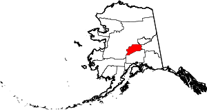 | |
| CDPs | ||
| Unincorporated communities | ||