Sunset Beach, Oregon
| Sunset Beach, Oregon | |
|---|---|
| Unincorporated community | |
 Sunset Beach  Sunset Beach Location within the state of Oregon | |
| Coordinates: 46°6′4″N 123°55′50″W / 46.10111°N 123.93056°WCoordinates: 46°6′4″N 123°55′50″W / 46.10111°N 123.93056°W | |
| Country | United States |
| State | Oregon |
| County | Clatsop |
| Time zone | Pacific (PST) (UTC-8) |
| • Summer (DST) | PDT (UTC-7) |
| GNIS feature ID | 1127744[1] |
Sunset Beach is a small unincorporated community located between the cities of Seaside and Warrenton in Clatsop County, Oregon, United States. Sunset Beach is located between U.S. Route 101, Neacoxie Lake and the Pacific Ocean. It serves as the northernmost access to the resort community of Surf Pines, and provides motor vehicle beach access. The "Fort to Sea Trail", which follows the route used by the Lewis and Clark Expedition when hiking from Fort Clatsop to the Pacific Ocean, ends at the beach access. A beach of the same name is west of the community.
See also
References
External links
- U.S. Geological Survey Geographic Names Information System: Sunset Beach (the beach west of the community)
Municipalities and communities of Clatsop County, Oregon, United States | ||
|---|---|---|
| Cities | 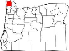 | |
| CDPs | ||
| Other unincorporated communities | ||
This article is issued from Wikipedia - version of the 7/30/2016. The text is available under the Creative Commons Attribution/Share Alike but additional terms may apply for the media files.