Stùc a' Chroin
| Stùc a' Chroin | |
|---|---|
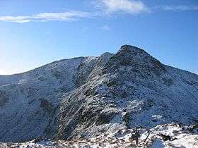 Northern ridge of Stùc a' Chroin, November 2004 | |
| Highest point | |
| Elevation | 975 m (3,199 ft) [1] |
| Prominence | 252 m (827 ft) |
| Parent peak | Ben Vorlich |
| Listing | Munro, Marilyn |
| Naming | |
| Translation | Peak of harm or danger (Gaelic) |
| Pronunciation | Gaelic [ˈs̪t̪uxk ə ˈxɾɔɲ] |
| Geography | |
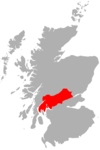
| Location |
Perth and Kinross/Stirling, Scotland |
| OS grid | NN617174 |
| Topo map | OS Landranger 57 |
Stùc a' Chroin is a mountain located in the southern part of the Highlands of Scotland. It lies to the south of Ben Vorlich, which is itself bounded to the north by Loch Earn, and to the west by Loch Lubnaig. The boundary between the council areas of Perth and Kinross and Stirling passes through the summit of the peak, and the town of Callander lies to the south.
Stùc a' Chroin is most often climbed in conjunction with Ben Vorlich from Ardvorlich on Loch Earnside to the north. The normal routes of ascent is over the summit of Ben Vorlich and down its south west ridge to the Bealach an Dubh Choirein. From this bealach a rough path cuts very steeply up on the right (NW) side of the prominent buttress to the summit of Stùc a' Chroin. Returning from the bealach, Ben Vorlich can be skirted by a pathless traverse of grassy slopes to the pass on its east.
An alternative is from Ardchullarie on Loch Lubnaig up the forest path to the head of Glen Ample and over Beinn Each, a Corbett. The linking ridge is very rough and rocky. On return, the open west slopes of Beinn Each can be descended, encountering the remarkable eggbox terrain of a large rock slope failure (see Lochearnhead, Glen Ample)[2]
A longer, unfrequented route of ascent to Stùc a' Chroin from Arivurichardich ascends the mountain's south east ridge.
References
- ↑ "walkhighlands Stuc a'Chroin". walkhighlands.co.uk. 2013. Retrieved 15 October 2013.
- ↑ Jarman D (2007): Glen Ample. In Mass Movements in Great Britain (ed. RG Cooper), Geological Conservation Review Series 33, Joint Nature Conservation Committee, Peterborough, pp. 82-91.
| Wikimedia Commons has media related to Stùc a' Chroin. |
- The Munros, SMC Hillwalkers Guide: Donald Bennett et al.: ISBN 0-907521-31-2
 |  | ||
Coordinates: 56°19′43″N 4°14′18″W / 56.32872°N 4.23826°W