Stockton Township, Jo Daviess County, Illinois
| Stockton Township | |
|---|---|
| Township | |
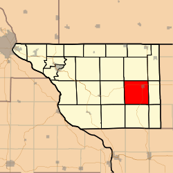 Location in Jo Daviess County | |
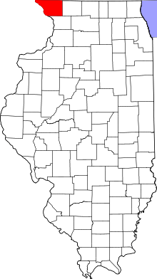 Jo Daviess County's location in Illinois | |
| Coordinates: 42°19′45″N 90°02′23″W / 42.32917°N 90.03972°WCoordinates: 42°19′45″N 90°02′23″W / 42.32917°N 90.03972°W | |
| Country | United States |
| State | Illinois |
| County | Jo Daviess |
| Established | November 2, 1852 |
| Government | |
| • Supervisor | Jon "Jack" Townsend |
| Area | |
| • Total | 37.01 sq mi (95.9 km2) |
| • Land | 37.01 sq mi (95.9 km2) |
| • Water | 0 sq mi (0 km2) 0% |
| Elevation | 876 ft (267 m) |
| Population (2010) | |
| • Total | 2,453 |
| • Density | 66.3/sq mi (25.6/km2) |
| Time zone | CST (UTC-6) |
| • Summer (DST) | CDT (UTC-5) |
| ZIP code | 61085 |
| GNIS feature ID | 0429801 |
Stockton Township is one of twenty-three townships in Jo Daviess County, Illinois, USA. As of the 2010 census, its population was 2,453 and it contained 1,141 housing units.[1]
Geography
According to the 2010 census, the township has a total area of 37.01 square miles (95.9 km2), all land.[1]
Cities, towns, villages
Adjacent townships
- Rush Township (north)
- Nora Township (northeast)
- Wards Grove Township (east)
- Berreman Township (southeast)
- Pleasant Valley Township (south)
- Derinda Township (southwest)
- Woodbine Township (west)
- Thompson Township (northwest)
Cemeteries
The township contains
Holy Cross Catholic Cemetery.
Ladies Union Cemetery
Major highways
Airports and landing strips
- John L Coppernoll Airport
- Stockton Airport
School districts
- Stockton Community Unit School District 206
Political districts
- Illinois' 16th congressional district
- State House District 89
- State Senate District 45
References
- "Stockton Township, Jo Daviess County, Illinois". Geographic Names Information System. United States Geological Survey. Retrieved 2010-01-17.
- United States Census Bureau 2007 TIGER/Line Shapefiles
- United States National Atlas
- 1 2 "Population, Housing Units, Area, and Density: 2010 - County -- County Subdivision and Place -- 2010 Census Summary File 1". United States Census. Retrieved 2013-05-28.
External links
- Jo Daviess County official site
- City-Data.com
- Illinois State Archives
- Township Officials of Illinois
Municipalities and communities of Jo Daviess County, Illinois, United States | ||
|---|---|---|
| Cities | ||
| Villages | ||
| Townships | ||
| CDPs | ||
| Other unincorporated communities | ||
| Ghost town | ||
This article is issued from Wikipedia - version of the 11/6/2016. The text is available under the Creative Commons Attribution/Share Alike but additional terms may apply for the media files.