Staveley, New Zealand
| Staveley | |
|---|---|
|
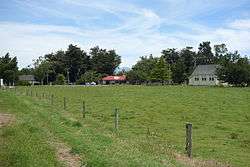
Staveley church (left), store, and the former Springburn School (relocated in 1996) | |
 Staveley | |
| Coordinates: NZ 43°39′S 171°26′E / 43.650°S 171.433°ECoordinates: NZ 43°39′S 171°26′E / 43.650°S 171.433°E | |
| Country | New Zealand |
| Region | Canterbury |
| Territorial authority | Ashburton District |
| Postcode | 7771 |
| Area code | 03 |
Staveley is a small township in the Ashburton District, Canterbury, New Zealand.
Geography
Staveley is named for Robert Staveley, who was a runholder in the area and who had his own farm in this location.[1][2] Staveley is located on the Inland Scenic Route, which is the former State Highway 72.[3] Staveley is located on the Canterbury Plains, in the foothills to the Southern Alps. Adjacent localities are Bushside to the north-east, Springburn to the south-east, and Buccleuch to the south, all between 2 and 4 kilometres (1.2 and 2.5 mi) away.[4] Springburn was the terminus of the Mount Somers Branch from 1889 to 1957.[5]
Town facilities
In the centre of the township, there are a shop and cafe, an old school that now functions as a museum, a small church, a hall, and a small number of houses. The museum holds photos and artefacts of settlements in the vicinity of Mt Somers / Te Kiekie,[6] a peak of 1,687 metres (5,535 ft) that is the backdrop to this parts of the Canterbury Plains.[7]
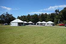
Staveley Camp is located on Sawmill Road and is available to groups only. The facility is owned by the Mid Canterbury District Bible group, who purchased the site in 1959 and constructed buildings (bunk houses, a kitchen, and meeting rooms) in 1971.[8]
Attractions

In 1949, locals built a natural ice rink. On busy days, the facility has hundreds of visitors.[9]
Staveley has two historic lime kilns. The older one, believed to have been constructed prior to 1890, was damaged in the 2010 Canterbury earthquake and has since been closed. The other one was built in 1898 and can be visited by the public, with sign posts in Staveley giving directions to the site.[10]
Ross Cottage at 63 Flynns Road is a historic cottage. In 1990, it was registered by the New Zealand Historic Places Trust (since renamed to Heritage New Zealand) as a Category II structure with registration number 5121.[11]
References
| Wikimedia Commons has media related to Staveley, New Zealand. |
- ↑ Reed, A. W. (2010). Peter Dowling, ed. Place Names of New Zealand. Rosedale, North Shore: Raupo. p. 374. ISBN 9780143204107.
- ↑ Acland, Leopold George Dyke (1946). The Early Canterbury Runs: Containing the First, Second and Third (new) Series. Christchurch: Whitcombe and Tombs Limited. pp. 325–326. Retrieved 15 January 2016.
- ↑ "Touring Routes". Experience Mid Canterbury. Retrieved 15 January 2016.
- ↑ Harriss, Gavin. "NZ Topo Map". NZ Topo Map. Retrieved 15 January 2016.
- ↑ "The Plains Vintage Railway & Historical Museum History". Ashburton Railway & Preservation Society. Retrieved 15 January 2016.
- ↑ "Staveley Historical and Geological Centre". NZMuseums. Retrieved 15 January 2016.
- ↑ "Mt Somers Track" (PDF). Department of Conservation. Retrieved 15 January 2016.
- ↑ "Staveley Camp Site". Staveley Campsite. Retrieved 15 January 2016.
see 'Rates' and 'History' tabs
- ↑ Sandys, Susan (28 June 2015). "Bumper crowd at Staveley Rink". Ashburton Guardian. Retrieved 15 January 2016.
- ↑ "Historic Staveley lime kilns". Department of Conservation. Retrieved 15 January 2016.
- ↑ "Ross Cottage". Register of Historic Places. Heritage New Zealand. Retrieved 15 January 2016.