Statesville, Tennessee
| Statesville, Tennessee | |
|---|---|
| Unincorporated community | |
 | |
 | |
| Coordinates: 36°01′10″N 86°07′30″W / 36.01944°N 86.12500°WCoordinates: 36°01′10″N 86°07′30″W / 36.01944°N 86.12500°W | |
| Country | United States |
| State | Tennessee |
| County | Wilson |
| Elevation | 722 ft (220 m) |
| Time zone | Central (CST) (UTC-6) |
| • Summer (DST) | CDT (UTC-5) |
| Area code(s) | 615 |
| GNIS feature ID | 1303808[1] |
Statesville is an unincorporated community in Wilson County, Tennessee. It is located along Tennessee State Route 267.
History
The community was first called Smith's Fork and was officially established in 1812, making it the second oldest town in Wilson County. Local resident William Bumpass donated land to be divided into 19 town lots. The community was originally named "Marysville" in honor of Mary Bumpass, William's wife. In 1818 the community applied for a post office. To avoid confusion with Maryville in east Tennessee, the town's name was changed to Statesville, chosen in honor of Statesville, North Carolina, as many residents had come from that location.[2]
The post office was established on March 29, 1819, and was twice discontinued before closing in 1935. The town became prominent in 1834 when one-fourth of the state's cotton mills were located there. During that time there were seven stores, five saloons, a wood shop, three blacksmith shops, and three harness, boot, and shoe shops.[2]
 Statesville United Methodist Church
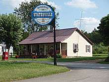 Street in Statesville
Notes
- ↑ "US Board on Geographic Names". United States Geological Survey. 2007-10-25. Retrieved 2008-01-31.
- 1 2 History of Wilson County, Tennessee - Its Land and its Life. Ed. G. Frank Burns. 238
Municipalities and communities of Wilson County, Tennessee, United States | ||
|---|---|---|
| Cities | ||
| Town | ||
| CDPs | ||
| Unincorporated communities | ||
| Ghost towns | ||