Stanchfield, Minnesota
| Stanchfield, Minnesota | |
|---|---|
| Census-designated place (CDP) and Unincorporated community | |
 Stanchfield, Minnesota Location of the community of Stanchfield | |
| Coordinates: 45°40′24″N 93°11′00″W / 45.67333°N 93.18333°WCoordinates: 45°40′24″N 93°11′00″W / 45.67333°N 93.18333°W | |
| Country | United States |
| State | Minnesota |
| County | Isanti |
| Township | Stanchfield Township |
| Area[1] | |
| • Total | 0.532 sq mi (1.38 km2) |
| • Land | 0.531 sq mi (1.38 km2) |
| • Water | 0.001 sq mi (0.003 km2) |
| Elevation | 942 ft (287 m) |
| Population (2010)[2] | |
| • Total | 118 |
| • Density | 220/sq mi (86/km2) |
| Time zone | Central (CST) (UTC-6) |
| • Summer (DST) | CDT (UTC-5) |
| Area code(s) | 763 |
| GNIS feature ID | 652540[3] |
Stanchfield is an unincorporated community and census-designated place (CDP) in Stanchfield Township, Isanti County, Minnesota, United States. As of the 2010 census, its population was 118.[2]
Isanti County Roads 3 and 36; and State Highway 65 (MN 65) are three of the main routes in the community.
The community is located between Cambridge and Braham. Grandy is nearby.
References
- ↑ "US Gazetteer files: 2010, 2000, and 1990". United States Census Bureau. 2011-02-12. Retrieved 2011-04-23.
- 1 2 "American FactFinder". United States Census Bureau. Retrieved 2011-05-14.
- ↑ "Stanchfield, Minnesota". Geographic Names Information System. United States Geological Survey.
- Rand McNally Road Atlas – 2007 edition – Minnesota entry
- Official State of Minnesota Highway Map – 2013/2014 edition
Municipalities and communities of Isanti County, Minnesota, United States | ||
|---|---|---|
| Cities | 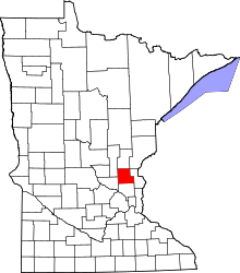 | |
| Townships | ||
| CDP | ||
| Unincorporated communities | ||
| Ghost town | ||
| Footnotes | ‡This populated place also has portions in an adjacent county or counties | |
This article is issued from Wikipedia - version of the 8/30/2014. The text is available under the Creative Commons Attribution/Share Alike but additional terms may apply for the media files.