St Day

Coordinates: 50°14′20″N 5°11′02″W / 50.239°N 5.184°W
St Day (Cornish: Sen Day) is a civil parish and village in Cornwall, England, United Kingdom. It is situated between the village of Chacewater and the town of Redruth.[1] The electoral ward St Day and Lanner had a population at the 2011 census of 4,473.[2]
St Day is located in a former mining area (which included Poldice, Tolcarne, Todpool, Creegbrawse and Crofthandy) and accrued considerable wealth from mining. The parish is at the heart of the Cornwall and West Devon Mining Landscape, a World Heritage Site that includes St Agnes, Chapel Porth and Porthtowan.
Industrial history
St Day was a centre for the richest and perhaps most famous copper mining district in the world from the 16th century to the 1830s. The population, wealth and activity in St Day declined steadily from about 1870 onwards, today the population is smaller than in 1841.[3] It is now essentially a residential village.
The Wheal Gorland mine is the type locality for the minerals Chenevixite, Clinoclase, Cornwallite and Liroconite.[4]
A St Day mine site has been used for short-oval stock car racing for many years. Stock car drivers from Cornwall have won 11 World Championships.
The population of St Day currently stands at 3069, reducing to a parish population of 1,821 at the census 2011[5]
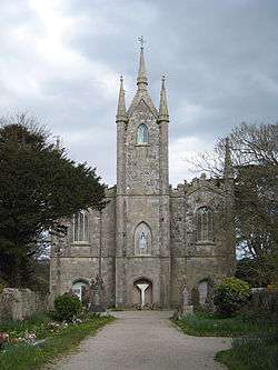
Parish church
The parish was originally a chapelry of Gwennap but became independent in 1835. In the 13th century there was a chapel dedicated to the Holy Trinity and even earlier there had been a chapel dedicated to St Day which was a great centre of pilgrimage.[6] The saint commemorated here is probably the Breton Saint Dei.[7]
References
- ↑ Ordnance Survey: Landranger map sheet 203 Land's End ISBN 978-0-319-23148-7
- ↑ "Ward population 2011". Ukcensusdata.com. Retrieved 12 February 2015.
- ↑ "Cornwall Industrial Settlements Initiative : ST DAY : (Gwennap Area)" (PDF). Historic-cornwall.org.uk. Retrieved 2015-12-31.
- ↑ "Wheal Gorland, St Day United Mines (Poldice Mines), Gwennap, Camborne - Redruth - St Day District, Cornwall, England, UK". Mindat.org. Retrieved 2015-12-31.
- ↑ "Parish population 2011". Genuki.org.uk. Retrieved 12 February 2015.
- ↑ Cornish Church Guide (1925) Truro: Blackford; p. 54
- ↑ Doble, G. H. (1964) The Saints of Cornwall: part 3. Truro: Dean and Chapter; ISBN 978-0902867017, pp. 133-139
External links
| Wikimedia Commons has media related to St Day. |
- St Day Civil Parish Council website
- Cornwall Record Office Online Catalogue for St Day
- GENUKI website; St Day
Cornwall Portal | |
| Unitary authorities | |
| Major settlements |
|
| Rivers | |
| Topics | |
Civil parishes of Camborne and Redruth constituency | ||
|---|---|---|
Cornwall Portal | ||