Southside, Alabama
| Southside, Alabama | |
|---|---|
| City | |
| Motto: "Rich in Hospitality and Genuine Southern Character" | |
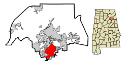 Location in Etowah County and the state of Alabama | |
| Coordinates: 33°54′13″N 86°1′34″W / 33.90361°N 86.02611°W | |
| Country | United States |
| State | Alabama |
| Counties | Calhoun, Etowah |
| Government | |
| • Type | Mayor-Council (5 members) |
| • Mayor | Wally Burns |
| Area | |
| • Total | 19.2 sq mi (49.6 km2) |
| • Land | 19.0 sq mi (49.2 km2) |
| • Water | 0.2 sq mi (0.4 km2) |
| Elevation | 620 ft (189 m) |
| Population (2010) | |
| • Total | 8,412 |
| • Density | 440.4/sq mi (169.9/km2) |
| Time zone | Central (CST) (UTC-6) |
| • Summer (DST) | CDT (UTC-5) |
| ZIP code | 35907 |
| Area code(s) | 256 |
| FIPS code | 01-71832 |
| GNIS feature ID | 0127146 |
| Website |
www |
Southside is a city in Etowah and Calhoun counties in the U.S. state of Alabama. It is included in the Gadsden Metropolitan Statistical Area. It incorporated in 1957.[1] The population was 8,412 at the time of the 2010 United States Census.[2] Located 8 to 12 miles (13 to 19 km) south of downtown Gadsden, Southside is one of the fastest growing cities in northeast Alabama.
In 2011, Southside narrowly escaped the massive devastation from the April 25–28, 2011 tornado outbreak which destroyed the community of Willow Point, just a few miles south of the city.
History
Southside was first settled in 1850 as a small rural community with townships such as Green Valley, Cedar Bend, and Pilgrims Rest, and the town of Southside was formed when they banded together. Early Southside's primary source of income was farming.
Geography
Southside is located in southern Etowah County on the south side of the Coosa River at 33°54′13″N 86°1′34″W / 33.90361°N 86.02611°W (33.903597, -86.026105).[3] A small part of the city extends south into Calhoun County. The city is in the foothills of the southern Appalachian Mountains.
According to the U.S. Census Bureau, the city has a total area of 19.2 square miles (49.6 km2), of which 19.0 square miles (49.2 km2) is land and 0.15 square miles (0.4 km2), or 0.87%, is water.[2]
Education
The city is served by the Etowah County Board of Education. The city has one elementary school, one high school, and shares a middle school with neighboring Rainbow City. Students also have the option of attending schools in the Gadsden City school system.
Demographics
| Historical population | |||
|---|---|---|---|
| Census | Pop. | %± | |
| 1960 | 436 | — | |
| 1970 | 983 | 125.5% | |
| 1980 | 5,141 | 423.0% | |
| 1990 | 5,580 | 8.5% | |
| 2000 | 7,036 | 26.1% | |
| 2010 | 8,412 | 19.6% | |
| Est. 2015 | 8,572 | [4] | 1.9% |
| U.S. Decennial Census[5] 2013 Estimate[6] | |||
As of the 2010 United States Census,[7] there were 8,412 people, 3,228 households, and 2,524 families residing in the city. The population density was 440.4 people per square mile (169.9/km²). There were 3,500 housing units at an average density of 183.2 per square mile (70.7/km²). The racial makeup of the city was 96.54% White, 1.46% Black or African American, 0.18% Native American, 0.67% Asian, 0.4% from other races, and 0.71% from two or more races. 1.27% of the population were Hispanic or Latino of any race.
There were 3,228 households out of which 35.9% had children under the age of 18 living with them, 65.86% were married couples living together, 9.08% had a female householder with no husband present, and 21.81% were non-families. 19.39% of all households were made up of individuals and 7.93% had someone living alone who was 65 years of age or older. The average household size was 2.58 and the average family size was 2.94.
Age distribution was 26.9% 19 years or younger, 4.5% from 20 to 24, 23% from 25 to 39, 36.7% from 45 to 64, and 13.4% who were 65 years of age or older. The median age was 40.1 years. For every 100 females there were 96.03 males. For every 100 females age 18 and over, there were 93.34 males.
As of the 2000 United States Census, the median income for a household in the city was $52,464, and the median income for a family was $58,427. Males had a median income of $41,664 versus $29,375 for females. The per capita income for the city was $21,936. About 2.2% of families and 3.6% of the population were below the poverty line, including 3.1% of those under age 18 and 5.4% of those age 65 or over.
Notable person
- Terry L. Dunn, former Associate Commissioner of the Alabama Public Service Commission
References
- ↑ http://www.encyclopediaofalabama.org/article/h-3183
- 1 2 "Geographic Identifiers: 2010 Demographic Profile Data (G001): Southside city, Alabama". U.S. Census Bureau, American Factfinder. Retrieved June 2, 2014.
- ↑ "US Gazetteer files: 2010, 2000, and 1990". United States Census Bureau. 2011-02-12. Retrieved 2011-04-23.
- ↑ "Annual Estimates of the Resident Population for Incorporated Places: April 1, 2010 to July 1, 2015". Retrieved July 2, 2016.
- ↑ "U.S. Decennial Census". Census.gov. Retrieved June 6, 2013.
- ↑ "Annual Estimates of the Resident Population: April 1, 2010 to July 1, 2013". Retrieved June 3, 2014.
- ↑ "American FactFinder". United States Census Bureau. Retrieved 14 December 2011.
External links
Coordinates: 33°54′13″N 86°01′34″W / 33.903597°N 86.026105°W
Municipalities and communities of Calhoun County, Alabama, United States | ||
|---|---|---|
| Cities | 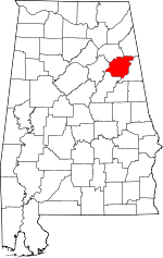 | |
| Towns | ||
| CDPs | ||
| Unincorporated communities | ||
| Ghost town | ||
| Footnotes | ‡This populated place also has portions in an adjacent county or counties | |
Municipalities and communities of Etowah County, Alabama, United States | ||
|---|---|---|
| Cities |  | |
| Towns | ||
| CDPs | ||
| Unincorporated communities | ||
| Footnotes | ‡This populated place also has portions in an adjacent county or counties | |