Site plan
- For Archaeological site plan, see Archaeological plan

A site plan is an architectural plan, landscape architecture document, and a detailed engineering drawing of proposed improvements to a given lot. A site plan usually shows a building footprint, travelways, parking, drainage facilities, sanitary sewer lines, water lines, trails, lighting, and landscaping and garden elements.[1]
Such a plan of a site is a "graphic representation of the arrangement of buildings, parking, drives, landscaping and any other structure that is part of a development project".[2]
A site plan is a "set of construction drawings that a builder or contractor uses to make improvements to a property. Counties can use the site plan to verify that development codes are being met and as a historical resource. Site plans are often prepared by a design consultant who must be either a licensed engineer, architect, landscape architect or land surveyor".[3]
Site plan topics
Site analysis
Site analysis is an inventory completed as a preparatory step to site planning, a form of urban planning which involves research, analysis, and synthesis. It primarily deals with basic data as it relates to a specific site. The topic itself branches into the boundaries of architecture, landscape architecture, engineering, economics, and urban planning. Site Analysis is an element in site planning and design. Kevin A. Lynch, an urban planner developed an eight cycle step process of site design, in which the second step is site analysis, the focus of this section.
Site plan building blocks
A site plan is a top view, bird’s eye view of a property that is drawn to scale. A site plan can show:Site Plans, Elevations and Floor Plans Plan Instructions (Site Plans, Elevations and Floor Plans)
- Property lines
- Outline of existing and proposed buildings and structures
- Distance between buildings
- Distance between buildings and property lines (setbacks)
- Parking lots, indicating parking spaces
- Driveways
- Surrounding streets
- Landscaped areas
- Easements
- Ground sign location
- Utilities
Site planning
Site planning in landscape architecture and architecture refers to the organizational stage of the landscape design process. It involves the organization of land use zoning, access, circulation, privacy, security, shelter, land drainage, and other factors. This is done by arranging the compositional elements of landform, planting, water, buildings and paving and building. Site planning generally begins by assessing a potential site for development through site analysis. Information about slope, soils, hydrology, vegetation, parcel ownership, orientation, etc. are assessed and mapped. By determining areas that are poor for development (such as floodplain or steep slopes) and better for development, the planner or architect can assess optimal location and design a structure that works within this space.
Transportation planning
Transportation planning is the field involved with the siting of transportation facilities (generally streets, highways, sidewalks, bike lanes and public transport lines). Transportation planning historically has followed the rational planning model of defining goals and objectives, identifying problems, generating alternatives, evaluating alternatives, and developing the plan. Other models for planning include rational actor, satisficing, incremental planning, organizational process, and political bargaining. However, planners are increasingly expected to adopt a multi-disciplinary approach, especially due to the rising importance of environmentalism. For example, the use of behavioral psychology to persuade drivers to abandon their automobiles and use public transport instead. The role of the transport planner is shifting from technical analysis to promoting sustainability through integrated transport policies.Southern, A. (2006), Modern-day transport planners need to be both technically proficient and politically astute, Local Transport Today, no. 448, 27 July 2005.
Urban planning
Urban, city, and town planning is the integration of the disciplines of land use planning and transport planning, to explore a very wide range of aspects of the built and social environments of urbanized municipalities and communities. Regional planning deals with a still larger environment, at a less detailed level. Based upon the origins of urban planning from the Roman (pre-Dark Ages) era, the current discipline revisits the synergy of the disciplines of urban planning, architecture and landscape architecture, varying upon from the interlectural strategic positioning from university to university.
Examples
- Site Plan sample created by 24hplans.com
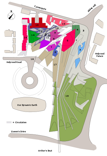 Scottish Parliament site plan.
 Lockefield Gardens - site plan.
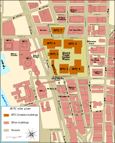 WTC Building Arrangement and Site Plan.
 Site plan of Tres Zapotes
See also
- Plot Plan
- Floor plan
- Landscape design
- Site Waste Management Plans Regulations 2008
- Surveying
- Archaeological plan
References
| Wikimedia Commons has media related to Site plans. |
- ↑ Department of Building and Development Land Development. Loudoun County Government. Accessed 11 Feb 2009. Archived May 27, 2010, at the Wayback Machine.
- ↑ Frequently Asked Questions Miami Township. Accessed 11 Feb 2009.
- ↑ Site Planning Process Chesterfield County, Virginia Planning Department. Accessed 11 Feb 2009. Archived March 29, 2009, at the Wayback Machine.
Further reading
- SCHWARZPLAN.eu - Download archive for site plans based on data by OpenStreetMap.org