Sinj
| Sinj | |
|---|---|
| City | |
|
View of Sinj | |
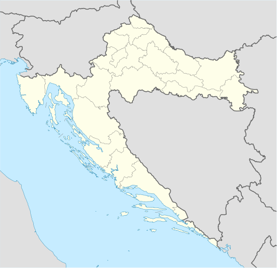 Sinj Location of Sinj in Croatia | |
| Coordinates: HR 43°42′9″N 16°38′17″E / 43.70250°N 16.63806°E | |
| Country |
|
| County |
|
| Government | |
| • Type | Mayor-Council |
| • Mayor | Kristina Križanac (Acting) (Independent) |
| • City Council |
Six parties/lists
|
| Area | |
| • City | 181 km2 (70 sq mi) |
| Elevation | 326 m (1,070 ft) |
| Population (2011)[1] | |
| • City | 24,826 |
| • Density | 140/km2 (360/sq mi) |
| • Urban | 11,478 |
| Time zone | CET (UTC+1) |
| • Summer (DST) | CEST (UTC+2) |
| Postal code | 21230 |
| Area code | +385 021 |
| Vehicle registration | ST |
| Website | http://www.sinj.hr/ |

Sinj (pronounced [sîːɲ]) (Italian: Signo, German: Zein) is a town in the continental part of Split-Dalmatia County, Croatia. The town itself has a population of 11,478 and the population of the administrative municipality, which includes surrounding villages, is 24,826 (2011).[1]
Geography
Sinj is the center of an area known as Cetinska krajina, a group of settlements situated on a fertile karstic field (Sinjsko polje) through which the river Cetina passes. Sinj lies between four mountains: Svilaja, Dinara, Kamešnica and Visoka. Those mountains give Sinj its specific submediterranean climate (hotter summers and colder winters).
History
Sinj was seized by the Turks in 1524 who maintained control until 1686, when it was taken into possession by the Venetians.[2] The town grew around an ancient fortress held by the Ottomans from 16th until the end of 17th century, and the Franciscan monastery with the church of Our Lady of Sinj (Gospa Sinjska), a place of pilgrimage. The last Turkish siege in 1715 was repulsed.
After the Congress of Vienna in 1815 until 1918, the town (bilingual name SINJ - SIGN) was part of the Austrian monarchy (Austria side after the compromise of 1867), head of the district of the same name, one of the 13 Bezirkshauptmannschaften in the Kingdom of Dalmatia.[3] The Italian name alone was used before 1867.
Tourism


Sinj and Cetinska Krajina represent an interesting tourist area, and the major attraction is certainly the traditional Tilters Tournament of Sinj (Sinjska alka). It takes place every year on the first Sunday in August to commemorate the victory over the Turkish army in 1715. The tilters, dressed in the traditional costumes, ride on horseback in full gallop, trying to thrust a small ring (alka), hanging from a wire, with a lance. The tilter who scores the highest number of points (punat) is declared the victor.
The Museum of the Cetinska Krajina Region is in Sinj.
International relations
Twin towns — Sister cities
Sinj is twinned with:
|
|
Notable natives and residents
See also
References
- 1 2 "Population by Age and Sex, by Settlements, 2011 Census: Sinj". Census of Population, Households and Dwellings 2011. Zagreb: Croatian Bureau of Statistics. December 2012.
- ↑ Treasures of Yugoslavia, Yugoslaviapublic, Beograd, 1982
- ↑ Die postalischen Abstempelungen auf den österreichischen Postwertzeichen-Ausgaben 1867, 1883 und 1890, Wilhelm KLEIN, 1967
External links
| Wikimedia Commons has media related to Sinj. |
Subdivisions of Split-Dalmatia County | ||
|---|---|---|
| Cities and towns |  | |
| Municipalities |
| |
Coordinates: 43°42′N 16°38′E / 43.700°N 16.633°E