Bjelovar
| Bjelovar | |||||||
|---|---|---|---|---|---|---|---|
| City | |||||||
| Grad Bjelovar City of Bjelovar | |||||||
Top: Preradović Street; Center left: Bjelovar Town Hall; Center right: Cathedral and city park; Bottom left: Stjepan Radić Square; Bottom right: Borik memorial park | |||||||
| |||||||
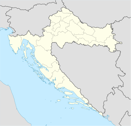 Bjelovar Location of Bjelovar in Croatia | |||||||
| Coordinates: 45°54′N 16°50′E / 45.900°N 16.833°ECoordinates: 45°54′N 16°50′E / 45.900°N 16.833°E | |||||||
| Country |
| ||||||
| County |
| ||||||
| Government | |||||||
| • Mayor | Antun Korušec (Ind.) | ||||||
| Area | |||||||
| • Total | 191.9 km2 (74.1 sq mi) | ||||||
| Elevation | 135 m (443 ft) | ||||||
| Population (2011) | |||||||
| • Total | 40,276 | ||||||
| • Density | 210/km2 (540/sq mi) | ||||||
| Time zone | CET (UTC+1) | ||||||
| • Summer (DST) | CEST (UTC+2) | ||||||
| Postal code | 43000 | ||||||
| Area code(s) | 043 | ||||||
| Vehicle registration | BJ | ||||||
| Website | bjelovar.hr | ||||||


.png)
Bjelovar (Hungarian: Belovár, German: Bellowar, Kajkavian: Belovar) is a city in central Croatia. It is the administrative centre of Bjelovar-Bilogora County. At the 2011 census, there were 40,276 inhabitants, of whom 91.25% were Croats.[1]
Bjelovar was first mentioned in 1413 and only gained importance when a new fort was built there in 1756, at the command of the Habsburg Empress Maria Theresa. The initial role of the city was to defend central Croatia against the Ottoman invasions. The town had to wait until the end of these wars to be pronounced a free royal town by ban Ivan Mažuranić in 1874.
History
The oldest Neolithic location in this area is in Ždralovi, a suburb of Bjelovar, where, while building a basement for the house of Josip Horvatić, a dugout was found and identified as belonging to the Starčevo culture (5000 – 4300 BC).[2][3][4] Finds from Ždralovi belong to a regional subtype of a late variant of the Neolithic culture. It is designated the Ždralovi facies of the Starčevo culture, or the final-stage Starčevo. There are also relics of the Korenovo culture, Sopot culture, Lasinja culture, and the Vučedol culture.[5]
After the drop of the Ottoman Empire domination, Bjelovar (named BELLOWAR before 1850[6] ) was part of the Austrian monarchy (Kingdom of Croatia-Slavonia after the compromise of 1867), in the Croatian Military Frontier, WARASDIN-KREUTZER Regiment N°V until 1881.
In the late 19th and early 20th century, Bjelovar was the seat of the Bjelovar-Križevci County of the Kingdom of Croatia-Slavonia.
From 1929 to 1939, Bjelovar was part of the Sava Banovina and from 1939 to 1941 of the Banovina of Croatia within the Kingdom of Yugoslavia.
Demographics
Population by settlement:[7]
- Bjelovar, population 27,024
- Breza, population 102
- Brezovac, population 1,080
- Ciglena, population 340
- Galovac, population 457
- Gornje Plavnice, population 687
- Gornji Tomaš, population 94
- Gudovac, population 1,095
- Klokočevac, population 828
- Kokinac, population 197
- Kupinovac, population 144
- Letičani, population 349
- Mala Ciglena, population 17
- Malo Korenovo, population 196
- Novi Pavljani, population 150
- Novoseljani, population 708
- Obrovnica, population 185
- Patkovac, population 257
- Prespa, population 511
- Prgomelje, population 696
- Prokljuvani, population 251
- Puričani, population 136
- Rajić, population 214
- Stančići, population 91
- Stare Plavnice, population 673
- Stari Pavljani, population 241
- Tomaš, population 241
- Trojstveni Markovac, population 1,301
- Veliko Korenovo, population 534
- Zvijerci, population 54
- Ždralovi, population 1,423
| year | total | Croats | Serbs | Yugoslavs | others |
|---|---|---|---|---|---|
| 1991 | 66,039 | 53,113 (80.42%) | 5,898 (8.93%) | 2,631 (3.98%) | 4,397 (6.65%) |
| 1981 | 66,553 | 48,819 (73.35%) | 5,897 (8.86%) | 9,249 (13.89%) | 2,588 (3.88%) |
| 1971 | 65,824 | 52,580 (79.87%) | 8,689 (13.20%) | 1,726 (2.62%) | 2,829 (4.29%) |
Geography


The city of Bjelovar stands on a plateau in the southern part of Bilogora (north-west Croatia), 135 metres above sea level. It is the capital of the Bjelovar-Bilogora county, and the natural, cultural and political centre of the area.
Bjelovar is at an intersection of roads in this area: the D28 intersects with the D43, and it lies on the road between Zagreb and west Slavonia, Podravina and Osijek. Bjelovar is currently being connected by dual carriageway with Zagreb.
The city of Bjelovar has an area of 191.9 km2 (74.1 sq mi), and administratively it includes 31 other areas. North-east of Bjelovar there is a long, low elevation called Bilogora, with an average height of 150–200 m (highest point: Rajčevica, 309 m). The geology of the area consists of Pliocene sandy marl and sandstones with lesser layers of lignite. Older rocks do not appear on the surface in this area. In deep boreholes there are crystalline rocks.
Bjelovar has a temperate continental climate. Winters are moderately cold and summers are warm. Precipitation of about 900 mm (35 in) per year is normal. The prevailing wind during winter is northerly, with easterlies becoming stronger in spring, when it may be quite cold, often blowing for a several days consecutively. In summer the wind is southerly; it is warm and more humid. The mean yearly temperature in Bjelovar is about 12 °C (54 °F).
Culture
Bjelovar contains three war memorials. The Barutana memorial area is dedicated to those who died defending the city on September 29, 1991, during the Croatian War of Independence. The Lug memorial area is dedicated to Ustashi soldiers killed by Partisans in 1945, and the Borik memorial area is dedicated to Partisans killed during the Second World War.
Bjelovar hosts the yearly "BOK" (Bjelovarski odjeci kazališta or Bjelovar Echoes of Theatre) theatre festival. It was founded and is run by Bjelovar actor Goran Navojec, and it hosts a selection of the best plays performed in Croatia during previous year.
Sport
In the 1970s, Bjelovar was known as the handball capital of Europe, when its local squad RK Bjelovar (under the name Partizan) dominated Croatian, Yugoslav, and European handball. The team came solely from Bjelovar and its environs.
International relations
Twin towns and sister cities
Bjelovar is twinned with:
 – Imotski, Croatia
- – Novalja, Croatia
- – Pakrac, Croatia
 – Rubiera, Italy
 – Visoko, Bosnia and Herzegovina
Notable natives and residents
- Đurđa Adlešič, Croatian politician
- Momčilo Bajagić, Serbian rock musician
- Bogdan Diklić, Serbian actor
- Petar Gorša, Croatian sports shooter
- Mario Petreković, Croatian comedian and actor
- Lavoslav Singer, Croatian industrialist
- Ognjen Vukojević, Croatian footballer
- Dragutin Wolf, Croatian industrialist
- Sonja Kovač, Croatian actress, model and singer
See also
References
Notes
- ↑ "Population by Ethnicity, by Towns/Municipalities, 2011 Census: County of Bjelovar-Bilogora". Census of Population, Households and Dwellings 2011. Zagreb: Croatian Bureau of Statistics. December 2012.
- ↑ Jakovljević, G. Arheološka topografija Bilogore, Bjelovarski zbornik ‘89, Bjelovar, 1989, pp 108–119
- ↑ Dimitrijević, S. Das Neolithikum in Syrmien, Slawonien und Nordwestkroatien — Einführung in den Stander Forschung, Archeologica Iugoslavica X, Belgrade, 1969, p 39-76 (45, 47)
- ↑ Dimitrijević, S. Sjeverna zona — Neolitik u centralnom i zapadnom dijelu sjeverne Jugoslavije, Praistorija jugoslavenskih zemalja II, Sarajevo, 1979, pp 229–360 (252–253)
- ↑ Jakovljević, G. Povijest naseljenosti bjelovarskog kraja do osnutka grada ; in: Slukan Altić, M. Povijesni atlasi gradova : I. vol. Bjelovar, Croatian State Archives and the State Archives in Bjelovar, 2003, pp 11–19
- ↑ Handbook of Austria and Lombardy-Venetia Cancellations on the Postage Stamp Issues 1850-1864, by Edwin MUELLER, 1961.
- ↑ "Population by Age and Sex, by Settlements, 2011 Census: Bjelovar". Census of Population, Households and Dwellings 2011. Zagreb: Croatian Bureau of Statistics. December 2012.
Bibliography
- Cresswell, Peterjon; Atkins, Ismay; Dunn, Lily (10 July 2006). Time Out Croatia (First ed.). London, Berkeley & Toronto: Time Out Group Ltd & Ebury Publishing, Random House Ltd. 20 Vauxhall Bridge Road, London SV1V 2SA. ISBN 978-1-904978-70-1. Retrieved 10 March 2010.
External links
| Wikimedia Commons has media related to Bjelovar. |
Subdivisions of Bjelovar-Bilogora County | ||
|---|---|---|
| Cities and towns |
|  |
| Municipalities | ||