Xindian District
| Xindian 新店區 | |
|---|---|
| District | |
| Xindian District | |
|
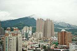
Xindian skyline | |
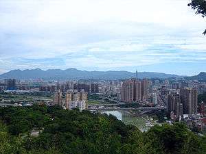
 Location of Xindian within New Taipei City | |
| Coordinates: 24°57′N 121°32′E / 24.950°N 121.533°E | |
| Country | Taiwan |
| Region | Northern Taiwan |
| Special municipality | New Taipei City |
| Area | |
| • Total | 120.2255 km2 (46.4193 sq mi) |
| Population (January 2016) | |
| • Total | 300,283 |
| • Density | 2,500/km2 (6,500/sq mi) |
| Time zone | CST (UTC+8) |
| Postal code | 231 |
| Website | http://www.xindian.ntpc.gov.tw/ |
| Xindian District | |||||||||||||||||||
| Chinese | 新店區 | ||||||||||||||||||
|---|---|---|---|---|---|---|---|---|---|---|---|---|---|---|---|---|---|---|---|
| |||||||||||||||||||
Xindian District (Chinese: 新店區; pinyin: Xīndiàn Qū) is an inner city district in the southern part of New Taipei City, Taiwan.
Name
Xindian's name originated during the Qing Dynasty close to 300 years ago. According to legend, a person named Lin and others came from Quanzhou, Fujian Province. On a mountain road leading to Wulai, they built a small cabin and opened a store selling groceries and for the exchange of goods with mountain aborigines. Since the store had no formal name, travelers called it Sintiam (Chinese: 新店; pinyin: Xīndiàn; Pe̍h-ōe-jī: Sin-tiàm; literally: "new store").
An area usually not considered as part of Xindian is Ankeng (安坑), although it is within the jurisdiction of the city, located in a valley on the west side of the Xindian Creek. It was originally called Amkhe'ar (暗坑仔; Ànkēngzǎi; Àm-kheⁿ-á; "dark/secret gorge"), due to luxurious vegetation in the area. However, it was later decided to be indecent and the name was changed to Ankeng (安坑; Ānkēng; An-kheⁿ; "peaceful gorge").
History
Empire of Japan
In 1920, during the period of Japanese rule, the area was established as Shinten/Shinden Town (Japanese: 新店街), Bunsan District, Taihoku Prefecture.
Republic of China
The Kuomintang government moved the seat of government (in exile) of Fujian Province to Xindian from 1956 to 1996. Although in 1980, it was still underdeveloped, the four-lane Zhongxing Road helped to develop the city. Areas south of Xiaobitan are still farmland. After the second National Highway opened, parks along Xiaobitan and Xindian Creek gave way to development. With the opening of the Taipei Metro, more commercial development and businesses have come into the area. In 2004 when the Tzu Chi Hospital branch opened, a new road was constructed to deal with traffic.
Originally established as urban township of Taipei County, Xindian was upgraded to a county-controlled city on 15 January 1980. After Taipei County was upgraded to New Taipei City on 25 December 2010, Xindian City became a district.
Geography
Xindian is located on the south side of the Taipei Basin, mainly on the plains between the Xindian Creek, its tributaries, and the mountains (the Xueshan Range). The Nanshi River merges with the Beishi River in Xindian, forming the Xindian Creek, one of the major tributaries of the Tamsui River. The Xindian Creek generally flows from south to north, dividing the city into east and west sides of the creek. Although the western side (Ankeng) covers a larger area, residential, administrative, commercial, and transportation centers are all on the eastern side of the creek at Dapinglin (大坪林). Population distribution in the Ankeng region is mainly concentrated in the southeastern hillside residential communities.
The district is located in southern New Taipei City. To the north is the Wenshan District of Taipei City and the Jingmei River, to the east it borders the district of Shiding, to the south it borders the district of Wulai, and to the west it borders the district of Sanxia.[1] Compared to other districts in New Taipei City, Xindian is more influenced by Taipei City; many public projects including the Taipei Metro, The Xiaobitan Branch Line and Xindian Line in this district. five stations of which are located in the city: Xiaobitan, Dapinglin, Qizhang, Xindian District Office and Xindian and the Feitsui Dam are in the district.
Xindian has many traditional markets that have decades of history. The Taipei County Police Department has ten divisions in Xindian.
Administrative divisions
Xindian is divided into 69 villages (里), then further divided in 1,447 neighborhoods (鄰).
Government agencies
- Architecture and Building Research Institute
- Aviation Safety Council
- National Airborne Service Corps
- National Fire Agency
- National Science and Technology Center for Disaster Reduction
Education
Universities
Vocational Schools
- Cardinal Tien College of Healthcare and Management
- Kaiming Senior Vocational School
- Nanqiang Senior Vocational School
- Zhuangjing Senior Vocational School
- Nengren Home Economics Vocational School
High Schools
- National Hsintien Senior High school
Junior High Schools
- Shiding Junior High School
- Ankang Junior High School
- Jiren Junior High School
- Chongguang Girls Junior High School
- Kangqiao Bilingual Experimental Junior High School (Private)
- Wenshan Junior High School
- Wufeng Junior High School
Elementary School
- Xindian Elementary School
- Zhitan Elementary School
- Guishan Elementary School
- Zhongzheng Elementary School
- Qingtan Elementary School
- Dafeng Elementary School
- Quchi Elementary School
- Ankeng Elementary School
- Shuangcheng Elementary School
- Beixin Elementary School
- Shuangfeng Elementary School
- Xinhe Elementary School
- Kangqiao Bilingual Experimental Elementary School (Private)
Tourist attractions
- Bitan
- Bitan Bridge (碧潭橋)
- Jing-Mei Human Rights Memorial and Cultural Park
- Zhongyang villages (中央新村)
- Feicui Reservoir (翡翠水庫)
- Xindian Creek
- Xiaobitan (小碧潭)
- Erbazi Botanical Garden (二叭子植物園)
- Xindian History Museum (新店文史館)
- Lion's Head Mountain (獅頭山)
- Little Lion's Head Mountain (小獅頭山)[2]
- Chen Feng-hsien Miniature Sculpture Museum (陳逢顯毫芒雕刻博物館)
Transportation
- Taipei Metro Xindian Line (4 stations)
- National Highway No. 3
Sister cities
 Tavares, Florida, USA (2010)[3]
- Flagstaff, Arizona, USA
Notable natives
- Shu Qi, artist
- Wang Yung-tsai, industrialist
Galleries
 Xindian Skyline
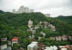
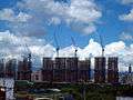 Construction in Xindian
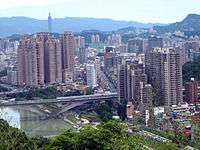
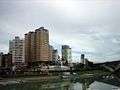 The Bitan
See also
| Wikimedia Commons has media related to Xindian District, New Taipei. |
References
- ↑ "轄區簡介". 臺北縣新店市戶政事務所. June 2010. Retrieved 2010-07-18.
- ↑ "Climbing into history at Lion's Head Mountain". The China Post. 2008-04-10. Retrieved 2010-07-18.
- ↑ http://www.tavares.org/index.aspx?nid=958
External links
- Xindian District Government website (Taiwanese Mandarin)
- Xindian City Government Website (Taiwanese Mandarin) (Archive)

Wikivoyage has a travel guide for Xindian.
Districts of New Taipei | ||
|---|---|---|
City seat: Banqiao | ||
| Northern |  | |
| Eastern | ||
| Western | ||
| Southern | ||
| Mountain indigenous district | ||
Note: Although Hanyu Pinyin is the national standard, the municipal government endorses and uses "New Taipei" instead of "Xinbei" and "Tamsui" instead of "Danshui." | ||
Coordinates: 24°57′N 121°32′E / 24.950°N 121.533°E