Shady Grove, Kentucky
| Shady Grove | |
|---|---|
| Unincorporated community | |
 Shady Grove  Shady Grove Location within the state of Kentucky | |
| Coordinates: 37°20′12″N 87°52′45″W / 37.33667°N 87.87917°WCoordinates: 37°20′12″N 87°52′45″W / 37.33667°N 87.87917°W | |
| Country | United States |
| State | Kentucky |
| County | Crittenden |
| Elevation | 423 ft (129 m) |
| Time zone | Central (CST) (UTC-6) |
| • Summer (DST) | CDT (UTC-5) |
| GNIS feature ID | 503209[1] |
Shady Grove is an unincorporated community within Crittenden County, Kentucky, United States.
History
A post office was established at Shady Grove in 1852, and remained in operation until it was discontinued in 1950.[2] In 1877, Shady Grove reportedly contained 2 churches, 3 stores, and 2 hotels.[3]
References
- ↑ U.S. Geological Survey Geographic Names Information System: Shady Grove, Kentucky
- ↑ "Crittenden County". Jim Forte Postal History. Retrieved 4 January 2015.
- ↑ Collins, Lewis (1877). History of Kentucky. p. 146.
Municipalities and communities of Crittenden County, Kentucky, United States | ||
|---|---|---|
| Cities | 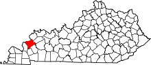 | |
| CDPs | ||
| Other unincorporated communities | ||
This article is issued from Wikipedia - version of the 10/19/2016. The text is available under the Creative Commons Attribution/Share Alike but additional terms may apply for the media files.