Searles, Minnesota
| Searles, Minnesota | |
|---|---|
| Census-designated place | |
 Searles, Minnesota | |
| Coordinates: 44°13′43″N 94°26′05″W / 44.22861°N 94.43472°WCoordinates: 44°13′43″N 94°26′05″W / 44.22861°N 94.43472°W | |
| Country | United States |
| State | Minnesota |
| County | Brown |
| Area[1] | |
| • Total | 0.438 sq mi (1.13 km2) |
| • Land | 0.438 sq mi (1.13 km2) |
| • Water | 0 sq mi (0 km2) |
| Elevation | 997 ft (304 m) |
| Population (2010)[2] | |
| • Total | 171 |
| • Density | 390/sq mi (150/km2) |
| Time zone | Central (CST) (UTC-6) |
| • Summer (DST) | CDT (UTC-5) |
| ZIP code | 56084 |
| Area code(s) | 507 |
| GNIS feature ID | 651814[3] |
Searles is an unincorporated community and census-designated place in Brown County, Minnesota, United States. Searles is located on Minnesota State Highway 15 6 miles (9.7 km) south of New Ulm. Searles has a post office with ZIP code 56084.[4] As of the 2010 census, its population was 171.[2]
History
Searles was platted in 1899.[5] A post office was established at Searles in 1902.[6]
References
- ↑ "US Gazetteer files: 2010, 2000, and 1990". United States Census Bureau. 2011-02-12. Retrieved 2011-04-23.
- 1 2 "American FactFinder". United States Census Bureau. Retrieved 2011-05-14.
- ↑ "Searles". Geographic Names Information System. United States Geological Survey.
- ↑ United States Postal Service (2012). "USPS - Look Up a ZIP Code". Retrieved 2012-02-15.
- ↑ Upham, Warren (1920). Minnesota Geographic Names: Their Origin and Historic Significance. Minnesota Historical Society. p. 70.
- ↑ "Brown County". Jim Forte Postal History. Retrieved 11 April 2015.
Municipalities and communities of Brown County, Minnesota, United States | ||
|---|---|---|
| Cities | 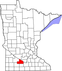 | |
| Townships | ||
| CDP | ||
| Unincorporated communities | ||
| Footnotes | ‡This populated place also has portions in an adjacent county or counties | |
This article is issued from Wikipedia - version of the 10/26/2016. The text is available under the Creative Commons Attribution/Share Alike but additional terms may apply for the media files.