Godahl, Minnesota
| Godahl, Minnesota | |
|---|---|
| Unincorporated community | |
 Godahl, Minnesota  Godahl, Minnesota | |
| Coordinates: 44°06′32″N 94°38′24″W / 44.10889°N 94.64000°WCoordinates: 44°06′32″N 94°38′24″W / 44.10889°N 94.64000°W | |
| Country | United States |
| State | Minnesota |
| County |
Brown Watonwan |
| Elevation | 1,043 ft (318 m) |
| Time zone | Central (CST) (UTC-6) |
| • Summer (DST) | CDT (UTC-5) |
| ZIP code | 56081 |
| Area code(s) | 507 |
| GNIS feature ID | 654726[1] |
Godahl is an unincorporated community in Brown and Watonwan counties in the U.S. state of Minnesota.
Location
Godahl sits on the boundary line for Brown and Watonwan counties, occupying two counties. The community is located between Sleepy Eye and St. James on Minnesota State Highway 4. The community is located at the junction of Minnesota State Highway 4 with County Roads 6 and 10.
History
Godahl was settled by Norwegian immigrants and named in honor of their home, called Gode Dahl ("Good Valley").[2] The town had a post office from 1894 until 1907, and a station of the Chicago, St. Paul, Minneapolis and Omaha Railway.[2] The community failed to develop, and today the only remnant of its commercial aspirations is the cooperative store built in 1894.[2]
References
- ↑ "US Board on Geographic Names". United States Geological Survey. 2007-10-25. Retrieved 2008-01-31.
- 1 2 3 Upham, Warren (2001). Minnesota Place Names, A Geographical Encyclopedia, 3rd Edition. Saint Paul, Minnesota: Minnesota Historical Society. p. 624. ISBN 0-87351-396-7.
Municipalities and communities of Brown County, Minnesota, United States | ||
|---|---|---|
| Cities | 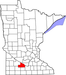 | |
| Townships | ||
| CDP | ||
| Unincorporated communities | ||
| Footnotes | ‡This populated place also has portions in an adjacent county or counties | |
Municipalities and communities of Watonwan County, Minnesota, United States | ||
|---|---|---|
| Cities | 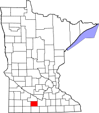 | |
| Townships | ||
| Unincorporated communities | ||
| Footnotes | ‡This populated place also has portions in an adjacent county or counties | |
This article is issued from Wikipedia - version of the 7/28/2016. The text is available under the Creative Commons Attribution/Share Alike but additional terms may apply for the media files.