Scoggins Creek
| Scoggins Creek | |
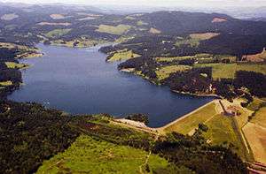 Aerial view of Henry Hagg Lake and Scoggins Dam | |
| Name origin: For pioneer settler Gustavus Scoggin [1] | |
| Country | United States |
|---|---|
| State | Oregon |
| Counties | Tillamook, Washington |
| Source | Northern Oregon Coast Range |
| - location | South Saddle Mountain, Tillamook County |
| - elevation | 2,948 ft (899 m) [2] |
| - coordinates | 45°33′16″N 123°22′23″W / 45.55444°N 123.37306°W [3] |
| Mouth | Tualatin River |
| - location | between Dilley and Gaston, Washington County |
| - elevation | 171 ft (52 m) [3] |
| - coordinates | 45°27′36″N 123°07′33″W / 45.46000°N 123.12583°WCoordinates: 45°27′36″N 123°07′33″W / 45.46000°N 123.12583°W [3] |
| Length | 19.2 mi (31 km) [4] |
| Basin | 45.1 sq mi (117 km2) [4] |
 Location of the mouth of Scoggins Creek in Oregon | |
Scoggins Creek, formerly known as "Scoggin Creek", is a 19-mile (31 km) tributary of the Tualatin River in Tillamook and Washington counties in the U.S. state of Oregon.[4] It is named for pioneer settler Gustavus Scoggin.[1]
Surrounded by lava and basalt flows and layers of sandstone,[5] it flows generally southeast from near South Saddle Mountain in the Northern Oregon Coast Range and through a 1,700-foot (520 m)-wide valley to Henry Hagg Lake, an impoundment of Scoggins Dam. Just downstream from the lake, the creek empties into the Tualatin River about 20 miles (32 km) west of Portland, at an elevation of 171 feet (52 m).[5][6][7] The creek enters the Tualatin River 60 miles (97 km) upstream of the Tualatin's confluence with the Willamette River.[4]
The five named tributaries of Scoggins Creek from source to mouth are Fisher, Parsons, Wall, Tanner, and Sain creeks. Wall, Tanner, and Sain enter at Hagg Lake.[8]
See also
References
- 1 2 McArthur, Lewis A.; McArthur, Lewis L. (2003) [1928]. Oregon Geographic Names (7th ed.). Portland, Oregon: Oregon Historical Society Press. p. 855. ISBN 0-87595-277-1.
- ↑ Source elevation derived from Google Earth search using GNIS source coordinates.
- 1 2 3 "Scoggins Creek". Geographic Names Information System. United States Geological Survey. November 28, 1980. Retrieved January 25, 2016.
- 1 2 3 4 Hawksworth, J. T.; Washington County Soil and Water Conservation District (February 2000). "Upper Tualatin-Scoggins Watershed Analysis" (PDF). Bureau of Land Management. pp. 1, 4–5. Retrieved July 16, 2015.
- 1 2 "Scoggins Dam". U.S. Bureau of Reclamation. May 5, 2009. Retrieved December 31, 2010.
- ↑ White, Greg (June 14, 2003). "Scoggins Creek steelhead trout redd surveys" (PDF). Retrieved December 31, 2010.
- ↑ "Scoggins Reservoir, Northwest Oregon". Find Lakes. Retrieved December 31, 2010.
- ↑ "United States Topographic Map". United States Geological Survey. Retrieved January 25, 2016 – via Acme Mapper.
External links
 Media related to Scoggins Dam at Wikimedia Commons
- The Tualatin Riverkeepers
- The Tualatin River Watershed Council